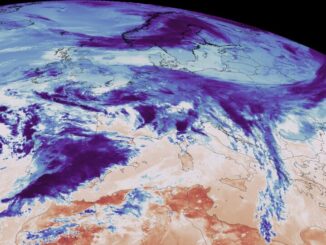
Earth Observation
Ontario Based SkyWatch raises $17.2M for its Earth Observation data platform
SkyWatch Space Applications Inc. (“SkyWatch“), a Waterloo-based space technology startup, announced today the completion of a $17.2M USD Series B round of financing…
ESA Advanced Training: Earth Observation & AI for Forestry
The European Space Agency (ESA) is organising an Advanced Training Course on Land Remote Sensing with the focus on Earth Observation and Artificial…
How Deploy Solutions can help bridge the communications gap in times of climate change crisis
Our Changing Climate The world we live in is changing, with global warming reshaping climate and causing more frequent, more…
Sustainable Land Cover And Land Use Monitoring with Satellite Imagery
Canada has a population of more than 37.9 million and is growing at a steady pace. Faced with a growing…
Share your Maps & Data: Soar.Earth jazzes up free access to satellite content every day
Geared towards the general public, Soar.Earth presents an online platform that resembles a digital, free-of-charge atlas. Pooling in from crowd-sourced…
GeoIgnite 2021 Announcement: Canadian Perspectives – The Power of Geospatial Literacy for Space, Earth Observation and Education – April 28th
GeoIgnite is delighted to announce the launch of a new summit at Canada’s National Geospatial Conference. Local Leadership – Global…
Canadian Geospatial Briefing March 1st – AI helping response to extreme weather; Inukshuk Geomatics celebrating 20 years; Telesat basing Lightspeed broadband operations in Gatineau; CATALYST Microservices – cloud-based earth observation processing; Canadian Coast Guard testing new UAV; GeoIgnite Career Fair April 14th
Artificial Intelligence helping respond to extreme weather events Researchers at the University of McGill are finding new ways to harvest…
MDA Announces Radarsat-2 Continuity Mission
February 2, 2021 MDA is excited to announce that the company has embarked on a major new initiative to build…
Canadian Space Agency announced a new funding opportunity
The Announcement of Opportunity is intended to address these issues by supporting the development of advanced space-based products and solutions aligned with…
Barbara J. Ryan steps up as the Executive Director of the World Geospatial Industry Council
The World Geospatial Industry Council (WGIC) is pleased to announce that Ms. Barbara J Ryan as its Executive Director, effective…
Your International Geospatial Briefing for January 11th : EA images major 2020 events; Maps are the future of smart cities & AV; Airbus-built CSO-2 French military Earth Observation satellite launched successfully; 2021 predictions for the drone industry; Indian Armed Forces ‘Reject’ Defense Ministry’s plan to ease norms On Geospatial Mapping.
Satellite images capture major events of 2020. The pandemic brought the world to a grinding halt in 2020, however that…
International Geospatial briefing for 30th November: Mapping the Ocean floor; Geospatial COVID-19 Vaccine distribution; Sydney beaches drone monitoring; UK Map sales soar; Software without Geospatial power has lost the plot.
Which Countries are Mapping the Ocean Floor? Significant progress has been made in Earth Observation around the world. Thousands of…