• facebook
  • Twitter
  • Linkedin
  • Youtube
  • Linkedin Group
  • Post a Job
  • Post an Ad
  • Post an Event
  • Post a Directory Listing
  • Post a Press Release
  • Media Kit
  • My Account
  • Login
GoGeomatics
  • MAGAZINE
    • BIM & GIS
    • Community
    • Conference news
    • Earth Observation
    • Education & Careers
    • GEOAI
    • Announcements
    • Reality Capture & Lidar
    • Science
    • Technology
  • Directories
    • ASSOCIATION
    • INDUSTRY
    • EDUCATION
    • Open Data
  • EVENTS
    • GeoIgnite Events
    • Events Calendar
    • GoGeomatics Meetups
  • Services
    • Advertising
    • Marketing
    • Post a Job
    • Post an Ad
    • Post an Event
    • Post a Press Release
    • Post a Directory Listing
    • Media Kit
    • Web Design
  • Find a Job
  • Volunteer
    • Start a GoGeomatics Group
    • Editors & Writers Group
  • About Us
    • About Us
    • Contact Us
    • Frequently Asked Questions
  • Videos
HomeFHIMP

FHIMP

Conference news

From Data to Action: FHIMP and the Future of Flood Risk Governance in Canada

29 May 2025 Kruti Mehta | Canada flood maps

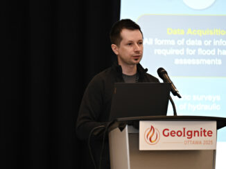
At GeoIgnite 2025, Maxim Fortin, Senior Engineer Advisor at Natural Resources Canada (NRCan), delivered a standout session on Canada’s evolving approach to flood hazard mapping. Representing the team behind the Flood Hazard Identification and Mapping […]

Community

Hydrospatial Advances Program For National Expo Announced

23 July 2024 GoGeomatics Expo | AI

A new program within the expo is the Hydrospatial program.  Here are the first talks announced. More to come! KEYNOTE: Alberta’s Flood Hazard and Fluvial Hazard Identification Initiatives The Government of Alberta’s Flood Hazard Identification […]

Technology

CANADA’S NATIONAL ELEVATION DATA STRATEGY UPDATE NOVEMBER 2023

18 December 2023 David Belanger | airborne topo-bathymetric

Fall 2023 LIDAR ACQUISITIONS 2023 IN SUPPORT OF THE FLOOD HAZARD IDENTIFICATION AND MAPPING PROGRAM (FHIMP) Since 2021, Natural Resources Canada (NRCan) has been leading the Flood Hazard Identification and Mapping Program (FHIMP) in partnership […]

||||
Technology

NRCAN Leading Initiative to Increase Canada’s Resilience to Flooding

13 May 2022 GoGeomatics Canada | Brian Perry

Geomatic Services Playing Key Role in Initiative On March 1, 2022, Brian Perry, Engineering Advisor for flood modeling with Natural Resources Canada (NRCAN) and Canada’s Centre for Mapping and Earth Observations, spoke during a livestream […]

Events

Notice
There are no upcoming events.

View All Events

Services

  • Post a Job
  • Post an Ad
  • Post an Event
  • Post a Directory Listing
  • Post a Press Release
  • Media Kit
  • My Account
  • Login

Jobs

Post a Job
  • Canada Maps and Poster Gallery Volunteer Leads — GeoIgnite 2026
    remote
  • GIS & Data Analytics Lead
    Beaumont, AB
  • Lead Surveyor, Projects/Arpenteur-géomètre principal, projets; arpenteuse-géomètre principale, projets
    North Bay, Thunder Bay
  • Senior GIS Developer
    Calgary, AB
View All Jobs
  • Directories
    • Associations Directory
    • Industry Directory
    • Education Programs
    • Open Data
  • Volunteer
    • Start a GoGeomatics Group
    • Editors & Writers Group
  • About Us
    • GoGeomatics Media Kit
    • Who We Are
    • Contact Us
    • FAQ’s
    • Advertising
    • Marketing
  • Subscribe
GoGeomatics
GoGeomatics is the largest and most popular communications hub promoting the Canadian geospatial community. The business was incorporated in 2011. GoGeomatics hosts over 100 fun, free, location technology networking events each year in cities across Canada.

© 2025 GoGeomatics

  • facebook
  • Twitter
  • Linkedin
  • Youtube
  • Linkedin Group