• facebook
  • Twitter
  • Linkedin
  • Youtube
  • Linkedin Group
  • Post a Job
  • Post an Ad
  • Post an Event
  • Post a Directory Listing
  • Post a Press Release
  • Media Kit
  • My Account
  • Login
GoGeomatics
  • MAGAZINE
    • BIM & GIS
    • Community
    • Conference news
    • Earth Observation
    • Education & Careers
    • GEOAI
    • Announcements
    • Reality Capture & Lidar
    • Science
    • Technology
    • Between the Poles
  • Directories
    • ASSOCIATION
    • INDUSTRY
    • EDUCATION
    • Open Data
  • EVENTS
    • GeoIgnite Events
    • Events Calendar
    • GoGeomatics Meetups
  • Services
    • Advertising
    • Marketing
    • Post a Job
    • Post an Ad
    • Post an Event
    • Post a Press Release
    • Post a Directory Listing
    • Media Kit
    • Web Design
  • Find a Job
  • Volunteer
    • Start a GoGeomatics Group
    • Editors & Writers Group
  • About Us
    • About Us
    • Contact Us
    • Frequently Asked Questions
  • Videos
Homeflood mapping

flood mapping

Community

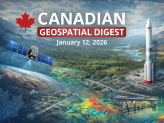
Canadian Geospatial Digest – February 23, 2026

23 February 2026 Volunteer Editors and Group Writers | Canada Defence Industrial Strategy

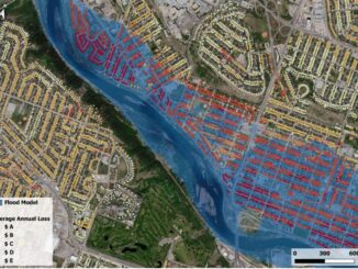
Canada launches first defence industrial strategy Quebec’s plan for digital sovereignty Dynamic Map Platform’s coast-to-coast coverage of Canadian roads Natural Resources Canada adds to existing flood event datasets NRCan-TAP: A partnership for building sustainable communities […]

Community

Flood Mapping and Community Concerns: A Canadian Perspective

26 January 2026 Benedicta Antwi Boasiako | Atlantic Canada

Summerside’s city council has voted against a proposed bylaw change that would have designated parts of the community as flood plain and coastal overlay zones. The decision followed a well-attended council meeting that drew about […]

Earth Observation

Canadian Geospatial Digest – January 12, 2026

12 January 2026 Volunteer Editors and Group Writers | 3D Digital twin

PhotoSat Launches Regional Hyperspectral Targeting Tool for Mineral Exploration NordSpace’s Atlantic Spaceport Clears Environmental Review, Moves Toward Canada’s First Orbital Launch Site 3D Mapping Pilot Shows How Indoor GIS Could Improve Safety in Edmonton’s LRT […]

Earth Observation

National Elevation Data Strategy: A Decade of Innovation and Progress

27 November 2025 David Belanger | Building Footprints Automatically Extracted Buildings ArcticDEM

In 2015, Natural Resources Canada (NRCan) launched the National Elevation Data Strategy (NEDS), a bold initiative to modernize Canada’s landmass data foundation. Ten years later, the NEDS has become a cornerstone of Canada’s geospatial ecosystem, delivering […]

digest Sept 1
Community

Canadian Geospatial Digest – September 1, 2025

1 September 2025 Volunteer Editors and Group Writers | aerospace industry

Vancouver-Based URSA Project Models Urban Resilience to Shape Climate Policy Quebec City First in Canada to Join Google’s Project Green Light Canadian Rocket Launches Signal Growth in Space Sector Port of Churchill Envisioned as Canada’s […]

Community

Canada’s National Geomatics Awards 2025: Cast Your Vote

18 August 2025 GoGeomatics Canada | business

Earlier this year, we invited Canada’s geomatics and geospatial community to nominate the individuals and organizations making a real difference in our sector. Now it’s time to make the final call for the Canada’s National […]

July 28 Digest
Community

International Geospatial Digest – July 28, 2025

28 July 2025 Volunteer Editors and Group Writers | business

Russia Signals Threat to Satellites Backing Ukraine NISAR Satellite to Deliver Global Radar Data at Unmatched Scale Planet Releases Tanager Hyperspectral Data for Public Exploration NASA Demonstrates Modular Satellite Design to Speed Up Sensor Launches […]

BIM & GIS

From Smart Maps to Safer Communities: Canada’s New Era of Flood Resilience

27 July 2025 Farzaneh Farshad | AI in Flood Modeling

In June 2025, the Government of Canada announced a $6.8 million investment in 20 new flood-mapping and adaptation projects under the Flood Hazard Identification and Mapping Program (FHIMP). These initiatives promise to revolutionize how we […]

Posts pagination

1 2 … 5 »

Events

Notice
There are no upcoming events.

View All Events

Services

  • Post a Job
  • Post an Ad
  • Post an Event
  • Post a Directory Listing
  • Post a Press Release
  • Media Kit
  • My Account
  • Login

Jobs

Post a Job
  • Operations Spatial Data Assistant (Contract)
    Vaughan
  • GIS Analyst
    Saint John, New Brunswick
  • GIS Student Intern
    Elmsdale, Nova Scotia
  • Canada Impact+ Research Chair – Professor (Or Associate Professor)
    Lethbridge, Alberta
View All Jobs
  • Directories
    • Associations Directory
    • Industry Directory
    • Education Programs
    • Open Data
  • Volunteer
    • Start a GoGeomatics Group
    • Editors & Writers Group
  • About Us
    • GoGeomatics Media Kit
    • Who We Are
    • Contact Us
    • FAQ’s
    • Advertising
    • Marketing
  • Subscribe
GoGeomatics
GoGeomatics is the largest and most popular communications hub promoting the Canadian geospatial community. The business was incorporated in 2011. GoGeomatics hosts over 100 fun, free, location technology networking events each year in cities across Canada.

© 2026 GoGeomatics

  • facebook
  • Twitter
  • Linkedin
  • Youtube
  • Linkedin Group