• facebook
  • Twitter
  • Linkedin
  • Youtube
  • Linkedin Group
  • Post a Job
  • Post an Ad
  • Post an Event
  • Post a Directory Listing
  • Post a Press Release
  • Media Kit
  • My Account
  • Login
GoGeomatics
  • MAGAZINE
    • BIM & GIS
    • Community
    • Conference news
    • Earth Observation
    • Education & Careers
    • GEOAI
    • Announcements
    • Reality Capture & Lidar
    • Science
    • Technology
  • Directories
    • ASSOCIATION
    • INDUSTRY
    • EDUCATION
    • Open Data
  • EVENTS
    • GeoIgnite Events
    • Events Calendar
    • GoGeomatics Meetups
  • Services
    • Advertising
    • Marketing
    • Post a Job
    • Post an Ad
    • Post an Event
    • Post a Press Release
    • Post a Directory Listing
    • Media Kit
    • Web Design
  • Find a Job
  • Volunteer
    • Start a GoGeomatics Group
    • Editors & Writers Group
  • About Us
    • About Us
    • Contact Us
    • Frequently Asked Questions
  • Videos
HomeFlood risk management

Flood risk management

BIM & GIS

From Smart Maps to Safer Communities: Canada’s New Era of Flood Resilience

27 July 2025 Farzaneh Farshad | AI in Flood Modeling

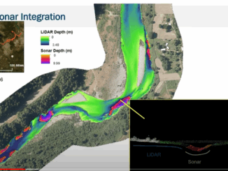
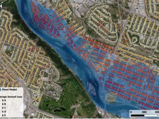
In June 2025, the Government of Canada announced a $6.8 million investment in 20 new flood-mapping and adaptation projects under the Flood Hazard Identification and Mapping Program (FHIMP). These initiatives promise to revolutionize how we […]

Technology

International Geospatial Digest May 22nd, 2023

22 May 2023 Volunteer Editors and Group Writers | ArcGIS

Google Geospatial Creator: Turning the world into AR stage. IBM’s new Geospatial foundation model could help monitor the earth’s climatic change. Tackling deforestation via geospatial AI. Can water conflicts be settled using satellites? Unpiloted aerial […]

|||||
Technology

NV5 Geospatial Discusses Remote Sensing and Analytics to Support Hydrospatial Solutions

3 June 2022 GoGeomatics Canada | analytics

A “Holistic Understanding of Water in Our World” At the March 1, 2022, GeoIgnite, Winter Geo conference, Sven Cowan, Canada Program Manager at NV5 Geospatial, and Mischa Hey, Practice Lead at Analytics at NV5 Geospatial, jointly […]

Technology

Canadian Geospatial Briefing for October 7th: EA Event Hosted By Government of Canada; Geosapiens Startup Business; Drone Delivery Canada; Alberta Greenhouse Report

7 October 2020 GoGeomatics Newsmakers | Alberta Agriculture

The Government of Canada to host webinar for its Space-Based Earth Observation strategy Canada Space Agency(CSA) has released which defines Space-Based Earth Observation (SBEO). The paper was discussed at the 41st Canadian Symposium on Remote […]

Events

Notice
There are no upcoming events.

View All Events

Services

  • Post a Job
  • Post an Ad
  • Post an Event
  • Post a Directory Listing
  • Post a Press Release
  • Media Kit
  • My Account
  • Login

Jobs

Post a Job
  • Canada Maps and Poster Gallery Volunteer Leads — GeoIgnite 2026
    remote
  • GIS & Data Analytics Lead
    Beaumont, AB
  • Lead Surveyor, Projects/Arpenteur-géomètre principal, projets; arpenteuse-géomètre principale, projets
    North Bay, Thunder Bay
  • Senior GIS Developer
    Calgary, AB
View All Jobs
  • Directories
    • Associations Directory
    • Industry Directory
    • Education Programs
    • Open Data
  • Volunteer
    • Start a GoGeomatics Group
    • Editors & Writers Group
  • About Us
    • GoGeomatics Media Kit
    • Who We Are
    • Contact Us
    • FAQ’s
    • Advertising
    • Marketing
  • Subscribe
GoGeomatics
GoGeomatics is the largest and most popular communications hub promoting the Canadian geospatial community. The business was incorporated in 2011. GoGeomatics hosts over 100 fun, free, location technology networking events each year in cities across Canada.

© 2025 GoGeomatics

  • facebook
  • Twitter
  • Linkedin
  • Youtube
  • Linkedin Group