Technology
Canadian Geospatial Briefing Nov 29: 1. Mapping Canada’s carbon landscape; 2. Satellite images of Flood in BC; 3. Royal Canadian Geographical Society awards; 4. High-speed internet for rural communities by asset-mapping; 5. Plant health beyond the naked eye
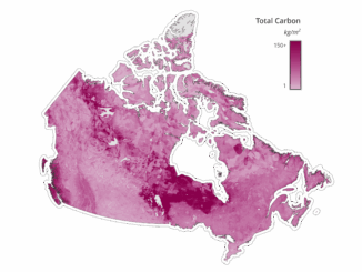
Mapping Canada’s carbon landascape WWF-Canada has conducted new research with the lead of McMaster University’s Remote Sensing Lab scientists to measure the stored amount of carbon in Canada’s landscape. The findings show that stored carbon […]