||||||
Technology

International Geospatial Briefing Feb 14th: 1. GIS in Transportation; 2. Black Culture Mapped Across the U.S.; 3. Geospatial Trends to Watch in 2022; 4. GIS & Disaster Damage Assessments; 5. Improving Opportunities for Women in Geospatial Careers; 6. Using AI to Measure Antarctic Surface Ice; 7. Tracking Wildfires in the Arctic

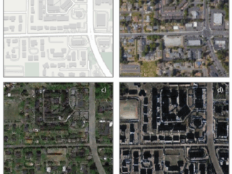
India using GIS to Improve and Expand Transportation Infrastructure India has the second-largest road and rail network in the world, and the logistical costs are higher than other countries of similar scale. These high costs […]

||||
Technology

International Geospatial Briefing May 3: Growing problem of deepfake satellite images; Bird migration map shows huge influx into Michigan; Google Earth timelapse visualizes human footprint; Remote Sensing to study chimoanzees; Mapping of childhood undernutrition in India

False satellite images created by machine learning raise concerns about the reliability of data AI technologies has been used to created false satellite images and the phenomenon of “deepfake geography” will eventually affect the quality […]

|||||
Technology

Canadian Geospatial Briefing March 1st – AI helping response to extreme weather; Inukshuk Geomatics celebrating 20 years; Telesat basing Lightspeed broadband operations in Gatineau; CATALYST Microservices – cloud-based earth observation processing; Canadian Coast Guard testing new UAV; GeoIgnite Career Fair April 14th

Artificial Intelligence helping respond to extreme weather events Researchers at the University of McGill are finding new ways to harvest data from Twitter to respond to natural disasters and other extreme weather events. They have […]

||
Technology

GeoIgnite 2020 Video, closing Keynote: Making earth observation (EO) intelligence available to the decision-makers that drive our future – June McAlarey, CEO PCI Geomatics

GeoIgnite is Canada’s national geospatial conference hosted by GoGeomatics Canada GeoIgnite was held online via Zoom from July 22nd to 24th, 2020.  This event showcased the Canadian geospatial community and the leaders of Canada’s location technology […]

|||
Technology

International Geospatial Briefing for November 2nd: Scottish Geospatial Network Integrator; Tracking Banana diseases using aerial imagery; Lidar data for faster building engineering and architecture; China’s 31st launch of 2020

New support to grow Scottish geospatial sector Although Scotland location-based sector is thriving, Scottish Enterprise’s research has revealed that further help is required to cultivate more collaboration in the geospatial sector. UK Government Geospatial Commission […]