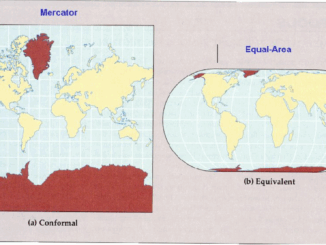
map
International Geospatial Briefing Sep 13th: Interactive Map Shows the Best Time to Photograph Fall Foliage; New interactive 3D map lets you see downtown Tampa in a new way; Geospatial Commission launches pilots to improve how data about land is used in the UK; Drop a Raindrop on This Magical Map and Watch Its Journey to the Ocean; FireWatch maps aim to help keep homes, community safe from wildfire; Geospatial Data Essential to Protect Snow Leopard in Mongolia
Interactive Map Shows the Best Time to Photograph Fall Foliage Photographers will not have difficulty planning fall photoshoots anymore and…
Canadian Geospatial Briefing Sep 7th: Grizzly genetics matching Indigenous boundaries; Drones in disaster planning and monitoring; Amber Alert app but for missing people with Dementia; 50 years of PEI’s landscape transformation; High-definition 3D map for Toronto
‘Mind blowing’: Grizzly bear DNA maps onto Indigenous language families The bears and Indigenous humans of coastal British Columbia have…
Canadian Geospatial Briefing July 19th, Drone spraying research promising; B.C. wildfire map; Manitoba Infrastructure Projects Map; N.B. COVID dashboard; New database of P.E.I. trails maps
Drone spraying research promising Drone spraying would be ideal for touch-ups and misses in a field after a large sprayer…
Mineral Exploration in Brazil with AI… the story behind the Map
Since the days of the first Gold Rush, when a prospector would head off into the bush with a shovel,…
International Geospatial Briefing March 8th: Geography, a cause for inequality; Drone Survey of a Wind Farm Access Road; Loss of soil study using satellite imagery; Japanese noisy children map; Minority-owned businesses map
Geography can become a root cause for inequality when cities are built in a way that fragments social networks A…
Geographic Illiteracy: Can you find Canada on the map?
Study shows 53% of the respondents unable to locate Canada Do you get lost all the time or even have…
What are Statistics Canada’s geographic terms: CT, CSD, CMA and more
Geographic data are applied in any location-based projects. We all might hear a lot about geographic terms but when we…
Things to know about Geographic Information Systems (GIS) as a Career
Introduction What is it that makes Geographical Information Systems (GIS) tool different from other tools? Why do most people want…
Your International Geospatial Briefing for May 11th: Geospatial paradigm shift; Coronavirus; GIS mapping; Geo predictions
The next paradigm shift in geospatial Geospatial solutions have changed the construction and surveying industry. This is evident by the…
Live Map with Updates Coronavirus (COVID-19) situation
You can find the latest facts and figures using this ArcGIS live update map below for the coronavirus. Here are…
2019-2020 Back to School Socials in Pictures – Thank you Sponsors & Participants!
The 6th annual GoGeomatics 2019 Back to School Socials have been a tremendous success. After coming off the success of…
Your International Geospatial Briefing for October 8th: Geospatial tech makes human life easier; Core Instrument to Transforming a Country? Geospatial Data.; Historians Map Migrations with Geospatial Tech; MAXAR Develops for the U.S. Air Force
Geospatial tech makes human life easier During the national conference at the Punjab Remote Sensing Centre on Big Geospatial Data…