
Education & Careers
The Myth of COGS
When Jonathan Murphy mentioned to me ‘the myth of COGS’ as a topic of conversation in Ottawa I agreed to research the subject. First of all one must consider the term “myth” and one definition […]
When Jonathan Murphy mentioned to me ‘the myth of COGS’ as a topic of conversation in Ottawa I agreed to research the subject. First of all one must consider the term “myth” and one definition […]
GoGeomatics Canada got in touch with Natural Resources Canada (NRCan) in order to ask them about all the most recent goings on over there on Booth Street in Ottawa. Michelle Viau, the Communications Advisor in […]
Jon Murphy knows how to ask some interesting questions – which is perhaps why I like reading what comes out from GoGeomatics. He asked me to write about missed opportunities in Canada that I have […]
Data acquisition is without a doubt one of the most important processes in the implementation of any GIS. As GIS professionals, it is imperative that we have access to and work only with spatial information […]
In 2000, I was just finishing a two year stint living in Belgium working on modeling downstream facilities. Yes, we used close-range photogrammetry. Really dull technical work, but we succeeded in projects across Europe (Italy, […]
In previous postings on GoGeomatics Canada (GIS in the School System & GIS Partnerships Between the Community and the Education System) I recounted my past experiences with recognizing the essential inclusion of using GPS and […]

At first glance, navigating the world has never been easier. Getting from Point A to Point B is a snap; just pop an address into your Global Positioning System (GPS) or pull up a map […]
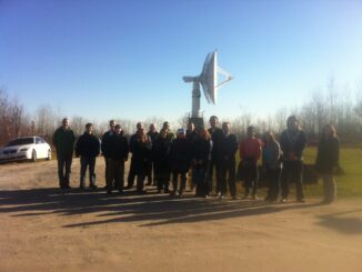
First off, HAPPY GIS DAY! Twitter was having a hayday with #GISDay tweets, and LinkedIn became a geospatial frenzy. What did you do for GIS Day? GoGeomatics Canada was happy to host our second annual […]