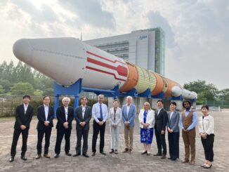
• facebook
  • Twitter
  • Linkedin
  • Youtube
  • Linkedin Group
  • Post a Job
  • Post an Ad
  • Post an Event
  • Post a Directory Listing
  • Post a Press Release
  • Media Kit
  • My Account
  • Login
GoGeomatics
  • MAGAZINE
    • BIM & GIS
    • Community
    • Conference news
    • Earth Observation
    • Education & Careers
    • GEOAI
    • Announcements
    • Reality Capture & Lidar
    • Science
    • Technology
  • Directories
    • ASSOCIATION
    • INDUSTRY
    • EDUCATION
    • Open Data
  • EVENTS
    • GeoIgnite Events
    • Events Calendar
    • GoGeomatics Meetups
  • Services
    • Advertising
    • Marketing
    • Post a Job
    • Post an Ad
    • Post an Event
    • Post a Press Release
    • Post a Directory Listing
    • Media Kit
    • Web Design
  • Find a Job
  • Volunteer
    • Start a GoGeomatics Group
    • Editors & Writers Group
  • About Us
    • About Us
    • Contact Us
    • Frequently Asked Questions
  • Videos
Homeremote sensing

remote sensing

Cassidy Rankine
Earth Observation

Mapping Crisis in Real Time: Cassidy Rankine on How Planet is Powering Canada’s Climate Response

9 June 2025 Anusuya Datta | Agriculture and Agri-Food Canada

As Canada enters yet another year of severe and increasingly frequent climate events — from early-season wildfires to flash floods and coastal erosion — governments are under growing pressure to adapt faster and act smarter. […]

Kevin Jones
Conference news

Building What’s Next: Kevin Jones on Innovation and Strategy at Catalyst

9 June 2025 Benedicta Antwi Boasiako | CATALYST

Catalyst, formerly known as PCI Geomatics, is one of Canada’s most recognized geospatial software companies, with a legacy that spans more than four decades in the Earth Observation (EO) space. Known for developing powerful remote […]

VS
Conference news

A Lifetime in Radar: Dr. Vernon Singhroy on Innovation, Influence, and Mentorship

6 June 2025 Benedicta Antwi Boasiako | AI

Dr. Vernon Singhroy is Canada’s one of the most distinguished Earth Observation scientists, known globally for his expertise in Synthetic Aperture Radar (SAR) and remote sensing applications. Over his decades-long career, he has published more […]

Canada wildfire 2025
Earth Observation

Canada is on Fire: Maps, Satellite Data, Smoke Forecasts Powering Emergency Response

2 June 2025 Anusuya Datta | air quality monitoring

Wildfires are raging across Canada — from British Columbia to Nova Scotia — in what is fast becoming another catastrophic fire season. Hot, dry weather and shifting wind patterns are converging to create another intense […]

Community

Unlocking the Power of EO and AI: Why Collaboration is No Longer Optional

2 June 2025 Benedicta Antwi Boasiako | Artificial Intelligence

A heavyweight panel of experts explored how Earth Observation (EO) and Artificial Intelligence (AI) can be scaled effectively — not through standalone tools, but through strategic collaboration and shared infrastructure. Held on May 14, 2025, […]

Digest
Community

International Geospatial Digest – June 2, 2025

2 June 2025 GoGeomatics Canada | AI

NASA Satellites Show Antarctica Gained Ice. How is that Possible? Map Shows 80% of Peatlands Dry and Degraded Tulsi Gabbard Signals Shift in U.S. Intelligence Collection Priorities NASA Scientists Reveal how Rrees can Predict Volcanic […]

Earth Observation

Charting the Future of GeoAI: A Conversation with Nadine Alameh

29 May 2025 Anusuya Datta | AI

What happens when geospatial stops following and starts leading? That’s the question Dr Nadine Alameh posed to the audience during her keynote at GeoIgnite 2025 in Ottawa. She urged the geospatial community to rethink its […]

EO and AI
Conference news

Emerging Trends in Geospatial and AI Innovation

29 May 2025 Bilyana Anicic | 3D Mapping

Recent advancements in geospatial and AI technologies are driving transformative changes across industries. These emerging trends, with a strong emphasis on collaboration and innovation, are unlocking new possibilities for addressing global challenges. Some of these […]

Posts pagination

« 1 … 8 9 10 … 71 »

Events

Notice
There are no upcoming events.

View All Events

Services

  • Post a Job
  • Post an Ad
  • Post an Event
  • Post a Directory Listing
  • Post a Press Release
  • Media Kit
  • My Account
  • Login

Jobs

Post a Job
  • Canada Maps and Poster Gallery Volunteer Leads — GeoIgnite 2026
    remote
  • GIS & Data Analytics Lead
    Beaumont, AB
  • Lead Surveyor, Projects/Arpenteur-géomètre principal, projets; arpenteuse-géomètre principale, projets
    North Bay, Thunder Bay
  • Senior GIS Developer
    Calgary, AB
View All Jobs
  • Directories
    • Associations Directory
    • Industry Directory
    • Education Programs
    • Open Data
  • Volunteer
    • Start a GoGeomatics Group
    • Editors & Writers Group
  • About Us
    • GoGeomatics Media Kit
    • Who We Are
    • Contact Us
    • FAQ’s
    • Advertising
    • Marketing
  • Subscribe
GoGeomatics
GoGeomatics is the largest and most popular communications hub promoting the Canadian geospatial community. The business was incorporated in 2011. GoGeomatics hosts over 100 fun, free, location technology networking events each year in cities across Canada.

© 2025 GoGeomatics

  • facebook
  • Twitter
  • Linkedin
  • Youtube
  • Linkedin Group