• facebook
  • Twitter
  • Linkedin
  • Youtube
  • Linkedin Group
  • Post a Job
  • Post an Ad
  • Post an Event
  • Post a Directory Listing
  • Post a Press Release
  • Media Kit
  • My Account
  • Login
GoGeomatics
  • MAGAZINE
    • BIM & GIS
    • Community
    • Conference news
    • Earth Observation
    • Education & Careers
    • GEOAI
    • Announcements
    • Reality Capture & Lidar
    • Science
    • Technology
  • Directories
    • ASSOCIATION
    • INDUSTRY
    • EDUCATION
    • Open Data
  • EVENTS
    • GeoIgnite Events
    • Events Calendar
    • GoGeomatics Meetups
  • Services
    • Advertising
    • Marketing
    • Post a Job
    • Post an Ad
    • Post an Event
    • Post a Press Release
    • Post a Directory Listing
    • Media Kit
    • Web Design
  • Find a Job
  • Volunteer
    • Start a GoGeomatics Group
    • Editors & Writers Group
  • About Us
    • About Us
    • Contact Us
    • Frequently Asked Questions
  • Videos
HomeTopobathymetric LiDAR Survey

Topobathymetric LiDAR Survey

Technology

NV5 Geospatial Collaborates with Communauté métropolitaine de Québec on Ambitious Topobathymetric Lidar Survey

3 August 2023 Sven Cowan | Canada

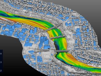
The earliest French settlers in North America were drawn in the 16th century to the area now known as Québec City, which sits on the north bank of the Saint Lawrence River and is home […]

||||||
Technology

NV5 Geospatial Supports Natural Resources Canada in Topobathymetric Lidar Survey of South and North Saskatchewan Rivers

6 June 2022 Sven Cowan | Canada

Over the last decade, a growing number of municipal and regional governments across North America have invested in topobathymetric lidar surveys of lakes, rivers and watersheds. Regional governments often commission new lidar survey projects, along […]

||||
Technology

NV5 Geospatial Helps Okanagan Basin Water Board Protect Important Local Communities Through Near-Shore Topobathymetric Lidar Survey

25 March 2022 Sven Cowan | British Columbia

The Okanagan Valley in British Columbia is one of Western Canada’s most attractive tourist destinations, with local communities offering a range of active and relaxing activities organized around the region’s many lakes and rivers. The […]

|||
Technology

NV5 Geospatial Supports Flood Risk Mapping in Montreal Through Canada’s Largest Riverine Topobathymetric Lidar Survey

20 October 2021 Sven Cowan | Canada

The Greater Montréal Area completed Canada’s largest-ever riverine topobathymetric lidar survey inresponse to two major flooding events within the last five years, which together displaced tens ofthousands from their homes and cost millions to local […]

|||
Technology

INSITE Lifecycle Project Tracker Enables & Delivers Real-Time Data Updates

19 April 2021 Sven Cowan | CMM

When conducting Lidar surveys, efficiency and success are determined to a degree by conditions outside of the surveyors’ control. The best-laid plans can sometimes be delayed by inclement weather conditions, as wind, rain and fog […]

||||||||||||||
Technology

GeoIgnite 2020 Video: Innovations and Lidar Applications for Trees & Water by Quantum Spatial Canada

28 September 2020 Celso Isidro | benthic habitats

The 2020 Geolgnite conference was put online and brought the Canadian geospatial sector together. One of the topics included updates from the Quantum Spatial Canada as presented by its Program Manager, Mr. Sven Cowan. Quantum […]

Events

Notice
There are no upcoming events.

View All Events

Services

  • Post a Job
  • Post an Ad
  • Post an Event
  • Post a Directory Listing
  • Post a Press Release
  • Media Kit
  • My Account
  • Login

Jobs

Post a Job
  • Canada Maps and Poster Gallery Volunteer Leads — GeoIgnite 2026
    remote
  • GIS & Data Analytics Lead
    Beaumont, AB
  • Lead Surveyor, Projects/Arpenteur-géomètre principal, projets; arpenteuse-géomètre principale, projets
    North Bay, Thunder Bay
  • Senior GIS Developer
    Calgary, AB
View All Jobs
  • Directories
    • Associations Directory
    • Industry Directory
    • Education Programs
    • Open Data
  • Volunteer
    • Start a GoGeomatics Group
    • Editors & Writers Group
  • About Us
    • GoGeomatics Media Kit
    • Who We Are
    • Contact Us
    • FAQ’s
    • Advertising
    • Marketing
  • Subscribe
GoGeomatics
GoGeomatics is the largest and most popular communications hub promoting the Canadian geospatial community. The business was incorporated in 2011. GoGeomatics hosts over 100 fun, free, location technology networking events each year in cities across Canada.

© 2025 GoGeomatics

  • facebook
  • Twitter
  • Linkedin
  • Youtube
  • Linkedin Group