
This article is the second piece in a series on reference system modernization. If you have not read the first article, you can find it here.
How Reference Systems Age
Reference systems are built to appear permanent. Once adopted, they anchor maps, land records, infrastructure designs, and scientific datasets. Because of this stability, they are often treated as fixed truths rather than evolving models.
But reference systems are models, and like all models, they reflect the measurement capabilities available when they were defined.
As measurement precision improves, differences begin to emerge between how the Earth is described and how it can actually be observed. At first, those differences are minor. They can be managed through updated realizations, refined station coordinates, or improved transformation parameters.
Over time, however, the underlying assumptions of the system may begin to show their age. The origin may no longer align with the physical Earth at the level of precision we can measure. The treatment of tectonic motion may reflect an era when millimetres were negligible. The representation of gravity may predate satellite-based observations.
When that happens, the overall system definition must be updated.
Modernization can be prompted by physical changes in the Earth, such as major earthquakes. More commonly, it occurs when measurement precision surpasses the assumptions built into the system’s original definition.
When Refinement Is Not Enough
In most cases, reference systems evolve through refinement rather than replacement. New realizations incorporate updated observations and improved modelling while preserving the original system’s definition.
A realization updates coordinates, heights and gravity within an established system. A modernization revisits the definition of the system itself.
As long as the system’s accuracy is sufficient to support the measurement accuracy required by its users, updated realizations can accommodate new observations without altering the underlying definition. In that case, the framework remains viable.
However, when the assumptions embedded in the structure, such as the definition of the origin, the treatment of crustal motion, or the representation of gravity, limit the system’s ability to support modern measurement precision, incremental updates begin to function as temporary adjustments rather than durable solutions.
At that stage, the question shifts from “How do we improve the coordinates?” to “Does the framework still reflect observable physics?”
This tension becomes especially visible in the treatment of time. Once crustal motion can be measured reliably, treating coordinates and heights as fixed begins to introduce systematic inconsistencies that accumulate year after year.
When Precision Exposes Structure
Prior to the era of continuous satellite geodesy, millimetre-scale crustal motion was not routinely observable. Terrestrial surveying techniques and early space-based methods improved global positioning significantly, but they did not provide the continuous, high-precision time series needed to resolve steady plate motion at the millimetre level.
In that environment, it was reasonable to treat coordinates as effectively constant. Small tectonic movements, gradual crustal adjustments, and slight misalignments in origin definitions did not meaningfully affect most practical applications.
That measurement environment has changed.
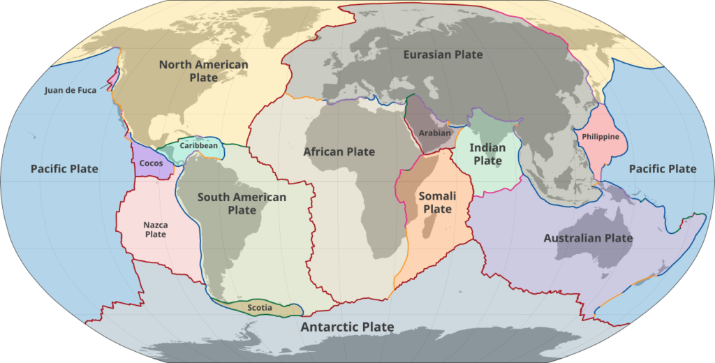
Modern GNSS operates in a different regime. Continuous observations from permanent stations now achieve repeatability at the millimetre level. At that precision, continental plate motion, on the order of a few centimetres per year for the North American plate, is clearly resolvable.
While early satellite positioning was already capable of detecting plate motion, improved positioning accuracy later revealed small biases in the plate motion models used in reference system definitions. In the case of NAD83, the NNR-NUVEL-1A plate motion model introduced an approximate 2 mm per year bias, which now manifests as an apparent plate rotation within the reference system.
This is where the distinction between a static frame and a dynamic frame becomes more than terminology.
A static frame assumes that once coordinates are assigned, they remain fixed unless disrupted by a major event. Time is not an explicit parameter in the definition.
A dynamic frame, by contrast, recognizes that positions evolve continuously. Coordinates are tied to a specific moment in time, known as an epoch. An epoch-dependent coordinate simply means that the value is valid for a particular date. As the ground moves, the coordinate changes in a predictable way.
For a non-specialist, the difference can be understood simply: a static frame treats coordinates as fixed at a reference epoch, even though the Earth’s crust remains dynamic due to tectonic motion and residual deformation. A dynamic frame, by contrast, accounts for that motion explicitly by defining coordinates as time-dependent within an Earth-fixed reference system.
Neither approach is inherently wrong. Each represents a different way of defining how motion is treated within a reference system. The challenge arises when a static framework is used in applications where time-dependent motion becomes operationally significant.
From Static Assumptions to Dynamic Reality
The tension between precision and definition is not theoretical. It has unfolded gradually across North America over the past several decades.
When NAD83 was established in the 1980s, it represented a major advancement in continental positioning. It was intended to be geocentric, tied to the Earth’s centre of mass, and capable of supporting the emerging era of satellite-based measurement. At the time, this level of alignment was more than sufficient for most practical applications.
But measurement did not stand still.
As GNSS networks expanded and continuous observation stations began recording millimetre-level changes, two structural characteristics of NAD83 became increasingly visible.
First, its origin is not perfectly aligned with the Earth’s true centre of mass. The resulting offset, now on the order of approximately 2.2m relative to modern global frames, is not the result of ground movement. It reflects the level of geocentric precision achievable when the system was defined.
Second, NAD83 operates within a largely static framework. While crustal motion models were introduced and refined over time, the system itself was not originally built around an epoch-dependent, fully dynamic treatment of continental motion. As positioning accuracy improved, small residual biases in the plate rotation model, on the order of a few millimetres per year, became detectable, revealing a mismatch between the static definition and observed motion.
These were not flaws in design. They were reflections of the era in which the system was created.
The important point is not that NAD83 was inadequate. It served Canada effectively for decades. The issue is that refinement alone could no longer fully reconcile the growing gap between observable motion and the framework used to describe it.
When that gap becomes structural rather than incidental, modernization becomes less a choice and more a technical necessity. The same structural logic applies vertically.
The Gravity Parallel
The vertical component of a reference system ages differently.
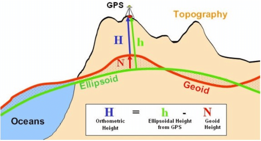
Horizontal positioning is primarily geometric: it depends on how positions relate to the Earth’s centre and how motion is modelled over time. Vertical positioning, by contrast, depends on gravity. Heights are not measured purely in geometric space; they are referenced to an equipotential surface that approximates mean sea level.
For much of the twentieth century, Canada’s vertical datum was built from spirit leveling networks extended across the country over decades. These surveys were remarkable engineering achievements. But leveling accumulates error. Small misclosures compound across long distances, and adjustments depend on assumptions that predate satellite-based gravity observation. For many years, these limitations had limited practical impact. Over time, however, satellite gravimetry and airborne gravity surveys began to provide a far more consistent picture of the Earth’s gravity field.
This introduced a similar tension to the one observed in horizontal positioning. When gravity can be modeled with increasing precision, vertical reference systems tied to historical leveling networks begin to show their age.
The shift toward gravity-based vertical datums, such as CGVD2013, reflects the same structural logic seen in geometric modernization. Rather than incrementally correcting distortions in an aging leveling framework, the underlying definition of height is re-anchored to a modern geoid model derived from contemporary observations.
Again, this is not a failure of the earlier system. It is a consequence of improved measurement. When the physics can be observed more accurately, the framework used to describe it must eventually follow.
When Redefinition Becomes Necessary
Redefining a reference system is never undertaken lightly. These systems support infrastructure, legal boundaries, engineering design, and scientific monitoring. Continuity matters.
But continuity does not imply permanence.
When observable motion and inherited definitions diverge beyond what refinement can reconcile, redefinition becomes a structural decision rather than a technical update.
This is not a rejection of earlier systems. It reflects the environment in which they were created. The Earth has always been dynamic. Gravity has always varied. What changes is our capacity to detect those realities with increasing precision.
Seen in this context, modernization is not a disruptive event. It is a predictable phase in the lifecycle of geodetic systems.
The next article in this series will explore how this lifecycle plays out in practice, including what changes users may notice and what remains reassuringly stable.
For official documentation and technical resources related to CSRS modernization, visit the CSRS modernization webpage.


Be the first to comment