
“It’s no longer enough to say ‘buy Canadian’—it has to be done in practice,” says Jacques Charron, President and CEO of K2 Geospatial. “Canadian tech firms often find it easier to sell abroad than here at home.”
It’s a pointed reflection from someone who has spent nearly three decades navigating the realities of Canada’s technology ecosystem. For K2 Geospatial, success has come from patience, persistence, and a clear focus on solving real problems through openness and interoperability.
Founded in Montreal in the mid-1990s, K2 has quietly grown into one of Canada’s most enduring geomatics firms — its solutions supporting municipalities, utilities, and infrastructure operators across North America and beyond. Yet Charron is quick to note that longevity in this sector requires more than technical innovation; it demands resilience in a system that often makes it harder for local firms to compete at home than abroad.
As Canada embarks on an ambitious wave of infrastructure and digital modernization, Charron sees a rare opportunity to close that gap. He argues that the country’s next phase of growth will depend not just on new technologies, but on a mindset shift — one that values trust, collaboration, and long-term investment in its own ecosystem.
In this conversation, Charron reflects on K2’s evolution, the realities of building a Canadian technology enterprise, and what it will take for Canada to strengthen its digital foundations from within.
K2 Geospatial has been quietly powering public infrastructure visualization for more than two decades. What problem were you trying to solve when you founded the company, and what guiding principle has sustained your growth from a Quebec-based innovator to a technology partner trusted across North America?
When we founded K2 in 1995, our goal was simple but ambitious: to enable organizations to truly see their data. At that time, the rise of the Internet was transforming the world, but infrastructure and territory-related data remained siloed in technical systems that were difficult to access.
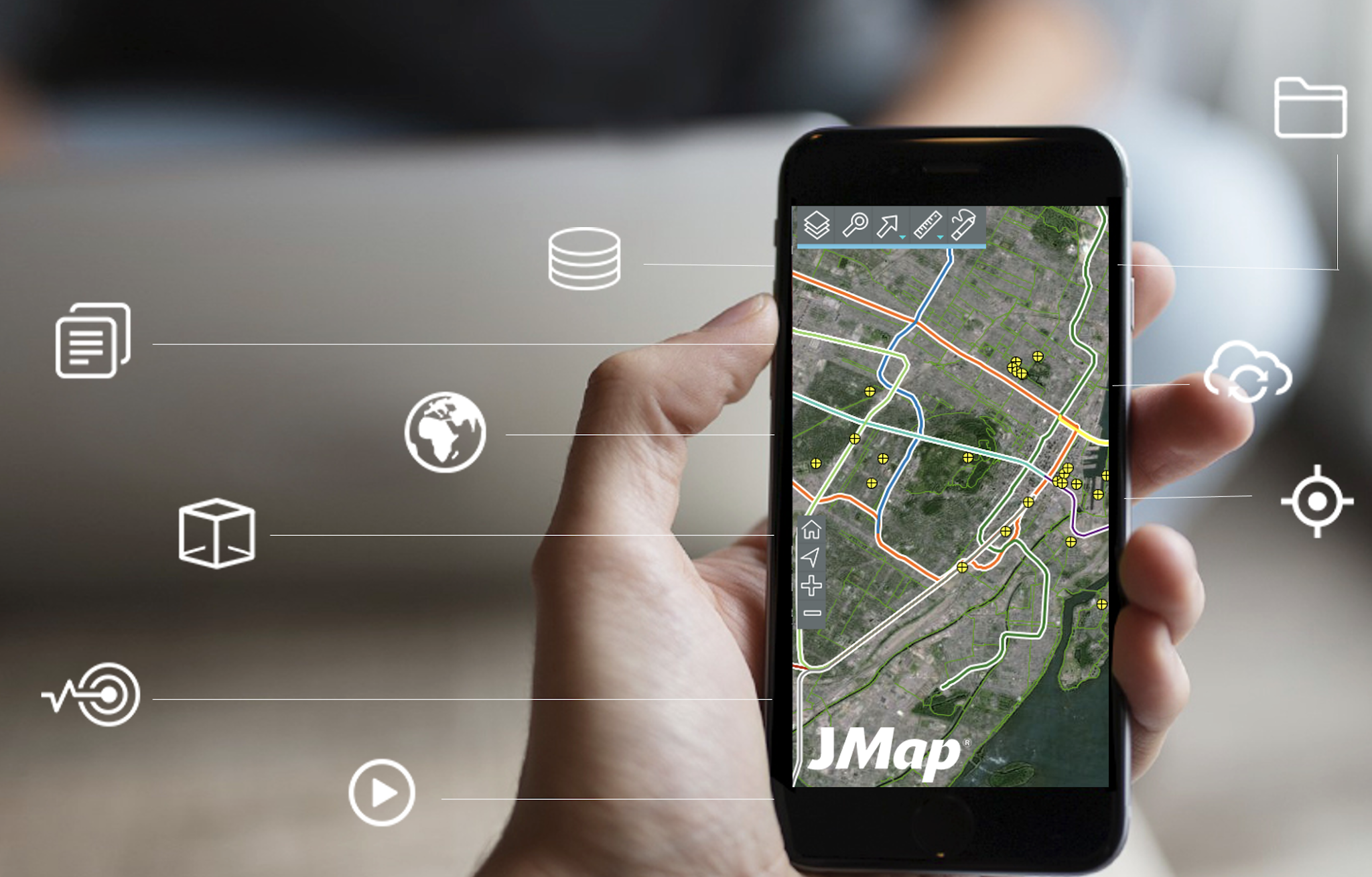
We developed JMap, a WebGIS platform designed to connect data, make it interoperable, and extend access beyond the circle of GIS experts.
Our first client was the City of Montreal in 1999. Today, JMap connects over 45 systems for the city and continues to support its strategic operations. Soon, other major organizations joined us: Rogers, the Port of Montreal, Rio Tinto, Air Liquide, the Stade de France, and Nestlé’s headquarters in Switzerland. Currently, JMap is deployed in over 500 organizations across North America, Latin America, and Europe.
K2 Geospatial specializes in developing and implementing innovative geospatial software solutions. Its flagship product, JMap, is used by more than 500 organizations, including over 400 Canadian municipalities. This wide adoption demonstrates the platform’s robustness, relevance, and longevity in the Canadian geospatial ecosystem.
This journey has been guided by a single founding principle: technology should make the world more understandable, not more complex. This vision informs every decision we make and has enabled K2 to become a trusted international partner while remaining deeply rooted in Canada.
What have been the greatest advantages and challenges of growing a homegrown company in Canada?
Canada is a particularly fertile ground for innovation: it offers talent, diversity, and scientific rigor that are admired worldwide. However, building a tech company here comes with structural challenges, particularly in accessing funding and navigating government procurement processes.
We had to learn to grow through quality, resilience, and trust, without relying on foreign capital. The greatest advantage of this approach is now our most significant strength: we own 100% of our intellectual property and control the full development of JMap, a 100% Canadian technology. This technological sovereignty is a major strategic advantage in a global market dominated by international giants.
Canada plans to allocate 1.5% of its GDP to infrastructure and civil preparedness. Are our procurement systems ready to manage such scale and urgency?
Not yet. Current processes often prioritize compliance over performance and value. To achieve its ambitions, Canada must make its procurement systems more agile, open to local innovation, and capable of assessing the strategic impact of technological choices.
It is no longer sufficient to simply say “buy Canadian”: it must be done in practice. Canadian tech companies export their solutions successfully abroad — often more easily than they can sell them domestically.
There’s a growing perception that Canadian-developed technologies and expertise are undervalued in procurement decisions. Have you encountered this, and what do you think drives it?
Yes, and this is a widely shared observation among Canadian SMEs. Despite their quality and maturity, local solutions are too often perceived as secondary to foreign offerings. This bias directly undermines technological sovereignty and weakens Canada’s capacity to innovate domestically.
Public investments, particularly in defense and infrastructure, present a historic opportunity: they must integrate and favor Canadian technology. Canada has been a global geospatial leader and has both the talent and technology to reclaim that strategic position.
How do you see Canada’s dependence on foreign systems and software affecting our ability to manage our own infrastructure future?
Dependence on foreign technology poses a real risk to strategic autonomy. When a country does not control the platforms that underpin its infrastructure, it is exposed to economic and security vulnerabilities.
For example, many Canadian infrastructures are hosted on cloud services subject to the U.S. Cloud Act, allowing the U.S. government to access data stored on Canadian soil. Strengthening digital sovereignty through Canadian-hosted solutions protected under local law is now urgent.
What current obstacles hinder local innovation — and what are the risks if procurement culture does not change?
Public procurement often favors administrative criteria inherited from the past rather than real innovation. This discourages tech SMEs, which are often the most agile and innovative actors in the market. If this culture persists, Canada risks:
- slowing down its own tech sector,
- losing talent and expertise to foreign competitors, and
- becoming dependent on platforms it does not control.
We are not asking for subsidies; we are asking for clients. Canadian companies need the confidence of their own governments to thrive.
K2’s mission has always been to break down data silos. How do you make it easier for organizations to connect and consolidate information scattered across different systems — one of the biggest issues in public infrastructure today?
Our approach is based on interoperability. JMap acts as a bridge between existing systems — databases, GIS, CMMS, IoT, vehicle tracking, technical documents, and more — without replacing them. With support for over 120 data formats and native integration of OGC and ISO standards, JMap unifies data without conversion or duplication.
The result: organizations gain a complete, real-time view of their territory, enhancing collaboration, operational efficiency, and decision-making.
Your flagship platform, JMap, is used by cities, utilities, and enterprises to visualize, analyze, and manage infrastructure data. For those new to it, what makes JMap unique among GIS and visualization tools?
JMap is more than a GIS: it is a data connection platform, collaboration tool, and a foundation for digital sovereignty. It transforms complex technical data into intelligible, actionable insights for all stakeholders — managers, engineers, elected officials, and citizens. The key features include:
- Technology-agnostic, interoperable, and non-intrusive
- Deployable on-premises (JMap Server) or as a sovereign cloud solution (JMap Cloud, hosted in Canada and not subject to the U.S. Cloud Act)
- Multilingual (French, English, Spanish)
- Integration with QGIS
- Development platform (PaaS) with APIs and full documentation
- Comprehensive ecosystem: analytics extensions, dashboards, 3D tools, mobility, IoT
JMap makes geospatial intelligence accessible, sovereign, and strategically essential for 21st-century infrastructure challenges.
Can you share a real-world example where your technology delivered measurable efficiency or collaboration gains?
A striking example of JMap’s impact is our solution for Info-Excavation, the organization behind Quebec’s “One Call” system for protecting underground infrastructure. Powered by JMap, Info-RTU allows major stakeholders — including Enbridge, TC Energy, Quebec’s Ministry of Transport, Bell, Énergir, Hydro-Québec, Vidéotron, the Montreal Electrical Services Commission, and numerous municipalities — to visualize all planned projects within public rights-of-way on an interactive map.
Info-RTU enables each organization to view upcoming works, identify potential overlaps, access project contacts, and share critical information in real time. The result is measurable: fewer project conflicts, improved inter-organizational coordination, and significant efficiency gains in infrastructure project execution.
This example perfectly illustrates JMap’s mission: transforming data into operational intelligence that fosters collaboration and serves the public good.
Looking ahead to the next decade, what is K2’s vision for shaping Canada’s digital infrastructure ecosystem?
Digital twins are more than 3D models. A true digital twin is an intelligent replica of the physical world: it represents geographic space, captures real-time operational status, tracks historical data, and enables predictive simulations.
JMap is designed for this purpose. As an interoperability platform, it connects multiple systems — databases, IoT sensors, management and maintenance systems — providing a unified, real-time, and historical view of assets. Advanced 2D and 3D visualization applications make this information dynamic and understandable.
The next step is predictive capabilities, powered by AI models that simulate behaviors, detect risks, and optimize infrastructure investment. Our focus is on evolving JMap into a full 2D/3D digital twin platform, integrating real-time, historical, and predictive data.
At K2 Geospatial, our mission is clear: to continue acting as a catalyst for innovation in the public interest. We believe the future of infrastructure will rely on flexible, sovereign, and intelligent platforms, and our role is to guide organizations through this transition in a human, sustainable, and strategically independent way.
K2 Geospatial is a valued sponsor of this year’s GoGeomatics Expo in Calgary. What will you be showcasing, and what message do you want attendees to take away about Canadian innovation?
Our participation at the GoGeomatics Expo in Calgary reflects a clear objective: to meet, listen to, and collaborate with the Canadian geospatial community. The event brings together top experts and a rich program that showcases the sector’s dynamism. For us, it is an opportunity to strengthen ties, share ideas, and co-create the next advances in the field.
We will showcase the latest JMap innovations, including real-time data integration, collaborative visualization tools, and our cloud platform, JMap Cloud, fully hosted in Canada. We will also demonstrate seamless integration with QGIS, showing how users can publish and share projects with a single click.
At the core of our message is Canadian digital sovereignty. Canada has the talent, technology, and ambition to lead globally. It is time to recognize, value, and elevate local innovation while building the digital infrastructure that will sustainably serve our collective future.


Be the first to comment