
COVID-19 (a new corona virus) topped news headlines in early 2020 when it broke out in Wuhan, China. The outbreak quickly became an international concern, and on January 30th, 2020 it was declared a Public Health Emergency of International Concern by the World Health Organization (WHO).
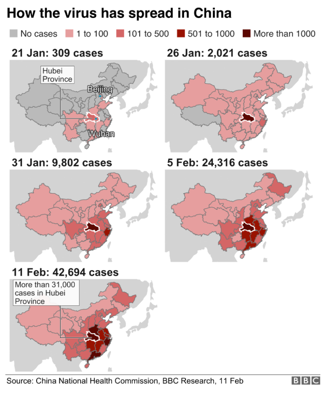
As public health institutions across the world mobilized to better understand this novel disease, GIS technology emerged as a key player in tracking and visualizing disease movement and activity. To stay up-to-date on this health crisis, WHO launched their own GIS dashboard (available here). In addition, news authorities like the BBC used maps to communicate the spread of the disease in both space and time. The image below was captured from this page on February 11, 2020.
Epidemiology is the study of diseases and their determinants. Space and time are two major components of the field. Space and time are also key components of Geography, making the two scientific fields an ideal match. Geographic Information Systems (GIS), is the technology regularly employed by scientists to make maps and perform geographic (spatial) analysis. Both mapmaking and spatial analysis have seen many technological advances in the past two decades. With the obvious overlap between geography and epidemiology, GIS has become an integral tool to assist with disease surveillance, perform research, and explore new associations between exposures and health outcomes.
The ability to use GIS and epidemiology to address emerging population health issues in our society are key components of the Population Health Data Analysis (PHDA) program. The program, delivered in partnership with the University of Victoria and Population Data BC, offers a four-course certificate which includes two geospatial courses focussed on health geography.
The first, Population Health and Geographic Information Systems (PHDA 03), focusses on the fundamentals of mapping health data and rudimentary spatial analysis. The second, Spatial Epidemiology and Outbreak Detection (PHDA 04), advances these topics and explores powerful analysis techniques involving spatial autocorrelation, space-time clustering, and spatial exposure assessments. To learn more about the upcoming May 2020 PHDA 04 course and the fully online program visit the PHDA homepage.


Be the first to comment