
Government agency pushes property portfolio into future with digitization
Real Property Services (RPS), a branch of Public Services and Procurements Canada, moves forwards to digitize their portfolio. Digitization will help RPS better understand and visualize their data and lead to better decision-making.
The department is looking to transit from paper to a Building Information Modeling system with pair data with geographic information systems and enterprise systems. With the digitization of projects, RPS are able to pick up issues in the building in early stage.
https://canada.constructconnect.com/joc/news/technology/2020/04/government-agency-pushes-property-portfolio-into-future-with-digitization
Connectus Global’s app aims to ensure safer return to work
A Calgary-based company develops app “QC-Clock” which is designed for businesses to screen employees to ensure a safer workplace when they return. The app, launched with a package including testing kits, sanitizer and personal protective equipment, calculates a risk score based on users’ activities, patterns of behaviour and interactions with locations.
All of the users’ data are encrypted on their own phones and a secure digital token is only available to user-specified people or organziations. The data never leaves the user’s phone.
https://calgaryherald.com/business/commercial-real-estate/connectus-globals-app-aims-to-ensure-safer-return-to-work/

COVID-19: Ministerial Coordination Group formed to maintain essential global links
Thirteen countries, convened by Canada, came together to form a Ministerial Coordination Group to fight the COVID-19 pandemic. The group has issued a declaration urging countries to maintain essential global links, especially with regards to trade and travel.
https://www.geospatialworld.net/news/covid-19-ministerial-coordination-group-formed-to-maintain-essential-global-links/
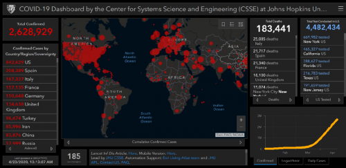
Mapping the curve: how GIS is helping the Covid-19 response
Dashboards are extensively used to share the information about COVID-19. Numerous organizations including World Health Organization, different academic institutions developed dashboards integrating datasets from authorities. Geographic Information Systems is a powerful tool to model scenarios and present information for this fight against the pandemic.
https://geographical.co.uk/people/development/item/3676-how-gis-is-helping-the-covid-19-response


Be the first to comment