
UK Government Calls for Launch of Geospatial Strategy: The data revolution
The UK has launched the Geospatial Commission to encourage the sector to take part in an evidence gathering initiative that will maximize the value of location data; the government predicts that this data has the potential to generate £11 billion a year. Of particular interest is innovation, enhancing geospatial assets, and driving investment. The Minister for the Cabinet Office David Lidington says that the call for evidence will help prepare the UK’s future Geospatial Strategy, which will launch in 2019.
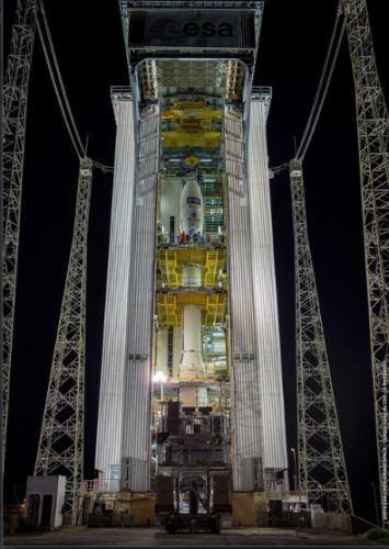
“Keeper of the winds”: Satellite Aeolus launches
New wind-mapping satellite Aeolus launched August 22nd, riding a Vega rocket care of European launch service Arianespace. Aeolus will follow a dawn/dusk orbit, broadly following the border between day and night on earth; its solar panels, therefore, will always receive the same amount of light from the sun. Using a Doppler wind lidar (a laser instrument called Aladin) the satellite will spend three years mapping Earth’s winds and probing the lower layers of the atmosphere to obtain information on clouds and aerosols. The data collected should improve our understanding of atmospheric dynamics and contribute to climate change research.
Developing a popular Story Map for Diario de Cuba using ArcGIS Online
Non-government, Madrid-based digital newspaper Diario de Cuba (DDC) is using Story Maps to highlight aspects of the publication’s content and boost readership. Using ArcGIS Online the consulting company Geoidea collaborated with DDC journalists to put Story Maps to work making news summaries and maps to cover specific news events. Improvements in GIS options plus the increase of journalism and public relations graduates taking geospatial courses means that Story Maps is the first of many GIS tools to make a mark on digital news reportage.
Apple incorporates location data to improve Machine Learning for SIRI
Despite major improvements in automatic speech recognition (ASR) technology in recent years, the ability to recognize place names and businesses still elude many devices. Apple is meeting that challenge by improving Siri’s speech recognition system with location technology. Geolocation-based language models will enable Siri to better estimate a user’s word sequence using both acoustic and language models and information about points of interest in the area.
Mapping in history’s footsteps
Surveyor Alan Volbrecht spent a month following the historic expedition of Sir George Everest through the Indian sub-continent, and ended up appreciating the dedication of early land mappers. In part 1 of this travel diary, he recounts his journey through Kathmandu and Delhi, his visits to key historical sights, and his successful navigation of the Survey of India, India’s sole Defence Mapping Agency. Entertaining as well as informative, Volbrecht’s article shows what a geospatialist can do with curiosity and a little persistence in the face of setbacks.


Be the first to comment