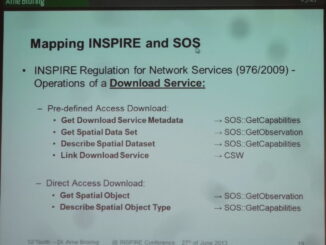
• facebook
  • Twitter
  • Linkedin
  • Youtube
  • Linkedin Group
  • Post a Job
  • Post an Ad
  • Post an Event
  • Post a Directory Listing
  • Post a Press Release
  • Media Kit
  • My Account
  • Login
GoGeomatics
  • MAGAZINE
    • BIM & GIS
    • Community
    • Conference news
    • Earth Observation
    • Education & Careers
    • GEOAI
    • Announcements
    • Reality Capture & Lidar
    • Science
    • Technology
    • Between the Poles
  • Directories
    • ASSOCIATION
    • INDUSTRY
    • EDUCATION
    • Open Data
  • EVENTS
    • GeoIgnite Events
    • Events Calendar
    • GoGeomatics Meetups
  • Services
    • Advertising
    • Marketing
    • Post a Job
    • Post an Ad
    • Post an Event
    • Post a Press Release
    • Post a Directory Listing
    • Media Kit
    • Web Design
  • Find a Job
  • Volunteer
    • Start a GoGeomatics Group
    • Editors & Writers Group
  • About Us
    • About Us
    • Contact Us
    • Frequently Asked Questions
  • Videos
Home2013

Year: 2013

3D data

Adoption of 3D GIS by European agencies

2 July 2013 Geoff Zeiss

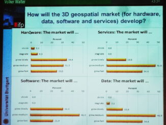
At the INSPIRE conference in Florence, Volker Walter presented the results of a EuroSDR Survey focussed on 3D data management in European national mapping (NMCAs) and cadastral agencies. 32 organizations were surveyed. 10 NMCAs 8 […]

3D data

Incorporating utilities into highway designs

1 July 2013 Geoff Zeiss

I have blogged numerous times about the challenge of accurately geolocating underground utilties. Most recently I blogged about the estimated ROI for investment in improving the geolocation and other information about underground utilities and the […]

No Picture
Between the Poles – The Geoff Zeiss Archives

Automated One-Call system in the Netherlands for excavation damage prevention

28 June 2013 Geoff Zeiss

I have blogged numerous times about the challenge of accurately geolocating underground utilties. Most recently I blogged about the estimated ROI for investment in improving the geolocation and other information about underground utilities and the […]

Between the Poles – The Geoff Zeiss Archives

Harmonizing OGC Sensor Observation Service and INSPIRE for real-time environmental monitoring

27 June 2013 Geoff Zeiss

The world is moving toward ubiquitous real-time automated monitoring of environmental parameters such as air quality and water level. The Open Geospatial Consortium (OGC) Sensor Observation Service (SOS)  applicable to use cases in which sensor […]

3D data

Open source project for 3D urban models supporting crowdsourced data and smart services

27 June 2013 Geoff Zeiss

Yesterday at the INSPIRE conference, Federico Prandi gave a presentation about a fascinating open source project called i-SCOPE that involves developing 3D urban models that can be used to provide interactive smart services. The concept […]

No Picture
Community

The TECTERRA GoGeomatics Halifax Social: Another Succesful Event

27 June 2013 GoGeomatics Canada | CanadianGIS

Last night GoGeomatics launched the first monthly networking event in Halifax. All told we counted 25-26 people at the event. We will be doing this once a month and we hope if you missed this […]

3D data

Compatibility between CityGML and INSPIRE Buildings data

26 June 2013 Geoff Zeiss

The INSPIRE Data Specifications Annex III contains use cases encodings and a data model for Buildings.  The devlopment of this schema was strongly influenced by CityGML, an Open Geospatial Consortium (OGC) standard developed initially in […]

Between the Poles – The Geoff Zeiss Archives

President Obama issues Executive Order making machine readable the default for Federal data

26 June 2013 Geoff Zeiss

G8 leaders (Canada, France, Germany, Italy, Japan, Russia, United Kingdom, United States, and the European Union) recently signed a charter on open data.   The Open Data Charter sets out 5 strategic principles that all G8 […]

Posts pagination

« 1 … 29 30 31 … 54 »

Events

Notice
There are no upcoming events.

View All Events

Services

  • Post a Job
  • Post an Ad
  • Post an Event
  • Post a Directory Listing
  • Post a Press Release
  • Media Kit
  • My Account
  • Login

Jobs

Post a Job
  • Junior Geomatics Field Technician – Technical Surveys
    Montréal, QC
  • GIS Specialist
    Amherst, Nova Scotia
  • Precast Structural BIM Specialist
    Calgary, Alberta
  • Precast Structural Project Coordinator (BIM)
    Calgary, Alberta
View All Jobs
  • Directories
    • Associations Directory
    • Industry Directory
    • Education Programs
    • Open Data
  • Volunteer
    • Start a GoGeomatics Group
    • Editors & Writers Group
  • About Us
    • GoGeomatics Media Kit
    • Who We Are
    • Contact Us
    • FAQ’s
    • Advertising
    • Marketing
  • Subscribe
GoGeomatics
GoGeomatics is the largest and most popular communications hub promoting the Canadian geospatial community. The business was incorporated in 2011. GoGeomatics hosts over 100 fun, free, location technology networking events each year in cities across Canada.

© 2026 GoGeomatics

  • facebook
  • Twitter
  • Linkedin
  • Youtube
  • Linkedin Group