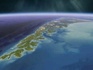
On the Importance of Mentoring in Geomatics
I guess I was lucky. It seems to me that I always wanted to be a civil engineer, but if asked I think we all have someone that we can identify as a mentor. The […]
Cambridge, ON – November 23, 2015 – exactEarth Ltd., the leading provider of Satellite AIS data services, announced today that it is investing AUD $2M to secure a minority ownership position in technology company, Myriota […]
This article was reprinted with permission from the Ontario Professional Surveyor, Volume 56, No. 3, Summer 2015 By Theresa Nicholsi, Scott Youngblutii, Jonathan Mooreiii and Ryan Harrisiii. The 2014 discovery of HMS Erebus, one of […]
This months speaker will be discussing his project mapping historic Ottawa. Kevin Ballantyne, Geomatics Specialist at MDA, will be giving a talk on his work mapping some of the lost parts of our community […]
The city of Ottawa has seen its urban landscape change throughout its history. As in many major cities, small buildings have been replaced with larger ones as the city grew. After Ottawa was chosen as […]
A friend of mine who volunteers with a girls’ softball team came to me with a request recently. “I have the addresses of all of the girls in our softball league”, she said. “I want […]
REGINA, Esri Canada User Conference – November 3, 2015 – Esri Canada today presented John Potter, a professional engineer who has retired from the government of Saskatchewan, with the Roger F. Tomlinson Lifetime Achievement Award […]
Elevation Web Services: Limitations and Prospects Elevation data is necessary for a wide range of geospatial applications such as creating relief maps and rendering 3D visualizations, deriving the slope and aspect of a geographic area, […]