• facebook
  • Twitter
  • Linkedin
  • Youtube
  • Linkedin Group
  • Post a Job
  • Post an Ad
  • Post an Event
  • Post a Directory Listing
  • Post a Press Release
  • Media Kit
  • My Account
  • Login
GoGeomatics
  • MAGAZINE
    • BIM & GIS
    • Community
    • Conference news
    • Earth Observation
    • Education & Careers
    • GEOAI
    • Announcements
    • Reality Capture & Lidar
    • Science
    • Technology
    • Between the Poles
  • Directories
    • ASSOCIATION
    • INDUSTRY
    • EDUCATION
    • Open Data
  • EVENTS
    • GeoIgnite Events
    • Events Calendar
    • GoGeomatics Meetups
  • Services
    • Advertising
    • Marketing
    • Post a Job
    • Post an Ad
    • Post an Event
    • Post a Press Release
    • Post a Directory Listing
    • Media Kit
    • Web Design
  • Find a Job
  • Volunteer
    • Start a GoGeomatics Group
    • Editors & Writers Group
  • About Us
    • About Us
    • Contact Us
    • Frequently Asked Questions
  • Videos
Home2018October

Month: October 2018

3D data

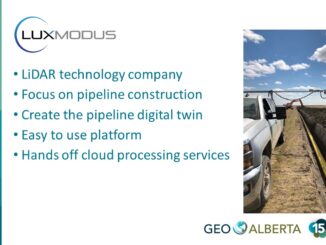
Towards a digital twin of infrastructure: efficient reality capture of new pipelines

30 October 2018 Geoff Zeiss

Traditionally when a new pipeline is put in the ground, either its location and depth is only approximately known or it has to be surveyed by a registered surveyor.  Now there is another alternative. At […]

No Picture
3D printing

Open source geospatial coordinate sytem libraries are being revised

30 October 2018 Geoff Zeiss

A “GDAL Coordinate System Barn Raising” has raised $144,000 to enable improvements to coordinate system libraries needed for the GDAL, PROJ, libgeotiff, PostGIS, and Spatialite open source toolchain. Support came from 25 players in the […]

Community

GoGeomatics Digests: We are your geospatial news source for Canada and abroad

29 October 2018 GoGeomatics Canada | digest

If you are new to GoGeomatics, you make have noticed our “GoGeomatics Canada News Briefing” and “Global Location Technology Digest” posts. These are what would on some websites be called a ‘News Roundup’: posts where […]

|||||
Technology

Your Canadian Geospatial Briefing for October 29th: Petawawa Research Forest; exactEarth; Jeff McKenna; Evergreen; Toronto’s geographic history

29 October 2018 GoGeomatics Canada | COGS

Tracking climate change with LiDAR Donna Kirkwood, the chief scientist at Natural Resources Canada (NRCan), marked the 100-year anniversary of the Petawawa Research Forest with a demonstration of Contour, a 3-D laser scanner. Contour uses […]

||
Technology

How does modern tech fit in geomatics?

24 October 2018 Grant Johnson | 3D printing

New technologies emerge all the time with lightning speed, but not all industries are equal in their rate of adopting the innovation. While fields such as business, medicine and manufacturing are at the forefront of […]

3D data

Bentley’s digital twin capabilities for cities includes underground infrastructure

23 October 2018 Geoff Zeiss

Proposed West Link tunnel under central Gothenburg More and more cities are recognizing the tremendous benefits that a digital twin provides to its planners, private architects and engineers striving for compliance with city ordinances and […]

|
Technology

Canada’s RADARSAT Constellation launch delayed

23 October 2018 GoGeomatics Canada | Canadian Space Agency

The launch of the Canadian Earth observation satellites (known collectively as the RADARSAT Constellation) has been delayed until February 2019. SpaceX originally planned to send the satellites up for ship location and Arctic observation in […]

Newsmakers & Press Releases

MDA starts the LaunchPad program for small and medium-sized Canadian Companies

22 October 2018 GoGeomatics Canada | Canada

MDA, a Maxar Technologies company announced announced the company’s LaunchPad program, which will serve as an entry point for innovative small and medium-sized Canadian companies and academic research groups seeking to collaborate with MDA on […]

Posts pagination

1 2 … 4 »

Events

Feb 16
February 16 @ 8:00 am - February 18 @ 5:00 pm

GeoWeek 2026

Feb 17
5:00 pm - 8:00 pm

Victoria GoGeomatics February Mappy Hour

Feb 17
6:00 pm - 8:00 pm

Calgary GoGeomatics February Social

Feb 18
6:30 pm - 8:30 pm

Vancouver GoGeomatics Meetup – February 2026

Feb 19
February 19 - February 22

Spatial Knowledge and Information Canada 2026

View Calendar

View All Events

Services

  • Post a Job
  • Post an Ad
  • Post an Event
  • Post a Directory Listing
  • Post a Press Release
  • Media Kit
  • My Account
  • Login

Jobs

Post a Job
  • Volunteer Editorial Contributor – Be Part of Canada’s Geomatics Story
    Remote
  • Junior Geomatics Field Technician – Technical Surveys
    Montréal, QC
  • GIS Specialist
    Amherst, Nova Scotia
  • Precast Structural BIM Specialist
    Calgary, Alberta
View All Jobs
  • Directories
    • Associations Directory
    • Industry Directory
    • Education Programs
    • Open Data
  • Volunteer
    • Start a GoGeomatics Group
    • Editors & Writers Group
  • About Us
    • GoGeomatics Media Kit
    • Who We Are
    • Contact Us
    • FAQ’s
    • Advertising
    • Marketing
  • Subscribe
GoGeomatics
GoGeomatics is the largest and most popular communications hub promoting the Canadian geospatial community. The business was incorporated in 2011. GoGeomatics hosts over 100 fun, free, location technology networking events each year in cities across Canada.

© 2026 GoGeomatics

  • facebook
  • Twitter
  • Linkedin
  • Youtube
  • Linkedin Group