• facebook
  • Twitter
  • Linkedin
  • Youtube
  • Linkedin Group
  • Post a Job
  • Post an Ad
  • Post an Event
  • Post a Directory Listing
  • Post a Press Release
  • Media Kit
  • My Account
  • Login
GoGeomatics
  • MAGAZINE
    • BIM & GIS
    • Community
    • Conference news
    • Earth Observation
    • Education & Careers
    • GEOAI
    • Announcements
    • Reality Capture & Lidar
    • Science
    • Technology
    • Between the Poles
  • Directories
    • ASSOCIATION
    • INDUSTRY
    • EDUCATION
    • Open Data
  • EVENTS
    • GeoIgnite Events
    • Events Calendar
    • GoGeomatics Meetups
  • Services
    • Advertising
    • Marketing
    • Post a Job
    • Post an Ad
    • Post an Event
    • Post a Press Release
    • Post a Directory Listing
    • Media Kit
    • Web Design
  • Find a Job
  • Volunteer
    • Start a GoGeomatics Group
    • Editors & Writers Group
  • About Us
    • About Us
    • Contact Us
    • Frequently Asked Questions
  • Videos
Home2018

Year: 2018

|
Newsmakers & Press Releases

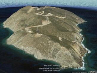
Transoft Solutions and Plexscape partnership offers the most realistic 3D vehicle representation on Google Earth

5 November 2018 GoGeomatics Newsmakers | 3D vehicle

Transoft Solutions Inc., a global leader in transportation engineering design and analysis software, has partnered with Plexscape, developers of Plex.Earth®, one of the most popular tools for AutoCAD for the acceleration of architectural, engineering and […]

||
Technology

Your Global Geospatial Briefing for November 5th: What the District; World Cities Day; Japanese satellite Ibuki-2; geomarketing; Geospatial Data Act

4 November 2018 GoGeomatics Canada | GDA

Using Maps to Visualize Gerrymandering in the age of Trump The ACLU’s “What the District?!” map allows users to trace the changing lines of democracy by tracking how local Congressional districts have been drawn, redrawn, […]

|||
Education & Careers

The New Innovative Master of Geomatics for Environmental Management (MGEM) Program at UBC

4 November 2018 Jon Murphy | British Columbia

This installment of our ongoing series on GIS and education in Canada features GoGeomatics talking to Dr. Trevor Jones, the Program Coordinator for the Master of Geomatics for Environmental Management (MGEM) program and lecturer in Forest […]

Between the Poles – The Geoff Zeiss Archives

The advantages of using open source components to develop geospatial web applications

2 November 2018 Geoff Zeiss

Open source geospatial software provides a way develop scalable solutions that avoid licensing costs and that can be adapted for particular requirements with the help of a large developer community. At GeoAlberta 2018, Ebrahim Poorazizi […]

Between the Poles – The Geoff Zeiss Archives

Using publicly available environmental data in a spatial analysis of low birth weight babies

1 November 2018 Geoff Zeiss

A spatial analysis of possible environmental factors contributing to the increase in the number of underweight babies born in Canada was presented by Charlene Nielsen at GeoAlberta 2018. Termed low birth weight at term (LBWT), […]

3D data

Towards a digital twin of infrastructure: efficient reality capture of new pipelines

30 October 2018 Geoff Zeiss

Traditionally when a new pipeline is put in the ground, either its location and depth is only approximately known or it has to be surveyed by a registered surveyor.  Now there is another alternative. At […]

No Picture
3D printing

Open source geospatial coordinate sytem libraries are being revised

30 October 2018 Geoff Zeiss

A “GDAL Coordinate System Barn Raising” has raised $144,000 to enable improvements to coordinate system libraries needed for the GDAL, PROJ, libgeotiff, PostGIS, and Spatialite open source toolchain. Support came from 25 players in the […]

|||||
Technology

Your Canadian Geospatial Briefing for October 29th: Petawawa Research Forest; exactEarth; Jeff McKenna; Evergreen; Toronto’s geographic history

29 October 2018 GoGeomatics Canada | COGS

Tracking climate change with LiDAR Donna Kirkwood, the chief scientist at Natural Resources Canada (NRCan), marked the 100-year anniversary of the Petawawa Research Forest with a demonstration of Contour, a 3-D laser scanner. Contour uses […]

Posts pagination

« 1 … 4 5 6 … 28 »

Events

May 25
May 25 - May 28

National Surveyors’ Conference 2026

May 27
May 27 @ 8:00 am - May 29 @ 5:00 pm

The Canadian Cartographic Association AGM

Jun 1
June 1 - June 4

CAG/CARTO Annual Meeting 2026

Jul 4
July 4 @ 8:00 am - July 11 @ 5:00 pm

ISPRS Congress 2026

Sep 15
September 15 - September 17

INTERGEO 2026

View Calendar

View All Events

Services

  • Post a Job
  • Post an Ad
  • Post an Event
  • Post a Directory Listing
  • Post a Press Release
  • Media Kit
  • My Account
  • Login

Jobs

Post a Job
  • Volunteer Editorial Contributor – Be Part of Canada’s Geomatics Story
    Remote
  • Junior Geomatics Field Technician – Technical Surveys
    Montréal, QC
  • GIS Specialist
    Amherst, Nova Scotia
  • Precast Structural BIM Specialist
    Calgary, Alberta
View All Jobs
  • Directories
    • Associations Directory
    • Industry Directory
    • Education Programs
    • Open Data
  • Volunteer
    • Start a GoGeomatics Group
    • Editors & Writers Group
  • About Us
    • GoGeomatics Media Kit
    • Who We Are
    • Contact Us
    • FAQ’s
    • Advertising
    • Marketing
  • Subscribe
GoGeomatics
GoGeomatics is the largest and most popular communications hub promoting the Canadian geospatial community. The business was incorporated in 2011. GoGeomatics hosts over 100 fun, free, location technology networking events each year in cities across Canada.

© 2026 GoGeomatics

  • facebook
  • Twitter
  • Linkedin
  • Youtube
  • Linkedin Group