• facebook
  • Twitter
  • Linkedin
  • Youtube
  • Linkedin Group
  • Post a Job
  • Post an Ad
  • Post an Event
  • Post a Directory Listing
  • Post a Press Release
  • Media Kit
  • My Account
  • Login
GoGeomatics
  • MAGAZINE
    • BIM & GIS
    • Community
    • Conference news
    • Earth Observation
    • Education & Careers
    • GEOAI
    • Announcements
    • Reality Capture & Lidar
    • Science
    • Technology
    • Between the Poles
  • Directories
    • ASSOCIATION
    • INDUSTRY
    • EDUCATION
    • Open Data
  • EVENTS
    • GeoIgnite Events
    • Events Calendar
    • GoGeomatics Meetups
  • Services
    • Advertising
    • Marketing
    • Post a Job
    • Post an Ad
    • Post an Event
    • Post a Press Release
    • Post a Directory Listing
    • Media Kit
    • Web Design
  • Find a Job
  • Volunteer
    • Start a GoGeomatics Group
    • Editors & Writers Group
  • About Us
    • About Us
    • Contact Us
    • Frequently Asked Questions
  • Videos
Home2019February

Month: February 2019

Between the Poles – The Geoff Zeiss Archives

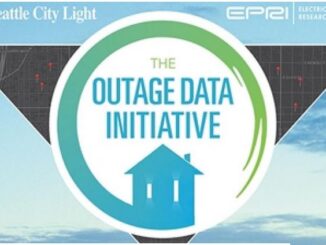
Sharing real-time utility outage information

7 February 2019 Geoff Zeiss

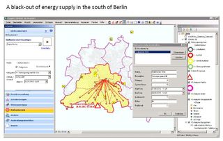
During natural and man-made emergencies, a major problem that emergency managers have to face is that, as Scott Sternfeld emphasized at the December Open Geospatial Consortium (OGC) Energy Summit at EPRI in Charlotte, there is […]

Augmented reality

Augmented reality aids disaster damage assessment by inexperienced utility workers

6 February 2019 Geoff Zeiss

One of the challenges of disaster response for utilities is situation assessment which involves sending utility personnel to the areas affected by a storm to assess the state of utility infrastructure. Skilled staff are often […]

|
Newsmakers & Press Releases

The Open Government Canada Team is organising its first Student Challenge!

6 February 2019 GoGeomatics Newsmakers | Canada

Are you a current or a recent student at a Canadian post-secondary institution?  We challenge you to share your work with the global open government community! The Open Government team at the Treasury Board Secretariat […]

3D data

Modeling multi-utility interdependent underground networks for disaster management in cities

5 February 2019 Geoff Zeiss

On this blog most of the discussion relating to underground infrastructure has been focused on construction focussing on the risks to workers and the public and the drag on the economics of construction.  There are […]

|||||
Technology

Your Canadian Geospatial Briefing for February 4th: Acadia; AI Centre; Exploring Earth; Canadian caribou; automated vehicles

4 February 2019 GoGeomatics Canada | acadia

Below the surface In a previous digest we introduced the ground-penetrating radar team surveying the historic site of Fort Anne. The group recently discovered what they believe to be the graves of as many as […]

|
Education & Careers

How to Write an Effective Geospatial & GIS Cover Letter

4 February 2019 Jon Murphy | Canada

When applying for a geospatial position, your cover letter provides the perfect opportunity to really make sense of your skills and experience, and to relate them to the job you are applying for. Keep your […]

Posts pagination

« 1 2 3

Events

Feb 24
5:30 pm - 7:30 pm

Kelowna Mural Map – User Feedback & Networking Social

Feb 24
6:30 pm - 8:30 pm

February Ottawa GoGeomatics Meetup

Feb 25
All day

Government Cybersecurity Showcase Federal 2026

Mar 1
March 1 - March 4

PDAC Convention 2026

Mar 10
March 10 - March 13

2026 ABCLS Conference and 121st Annual General Meeting

View Calendar

View All Events

Services

  • Post a Job
  • Post an Ad
  • Post an Event
  • Post a Directory Listing
  • Post a Press Release
  • Media Kit
  • My Account
  • Login

Jobs

Post a Job
  • Volunteer Editorial Contributor – Be Part of Canada’s Geomatics Story
    Remote
  • Junior Geomatics Field Technician – Technical Surveys
    Montréal, QC
  • GIS Specialist
    Amherst, Nova Scotia
  • Precast Structural BIM Specialist
    Calgary, Alberta
View All Jobs
  • Directories
    • Associations Directory
    • Industry Directory
    • Education Programs
    • Open Data
  • Volunteer
    • Start a GoGeomatics Group
    • Editors & Writers Group
  • About Us
    • GoGeomatics Media Kit
    • Who We Are
    • Contact Us
    • FAQ’s
    • Advertising
    • Marketing
  • Subscribe
GoGeomatics
GoGeomatics is the largest and most popular communications hub promoting the Canadian geospatial community. The business was incorporated in 2011. GoGeomatics hosts over 100 fun, free, location technology networking events each year in cities across Canada.

© 2026 GoGeomatics

  • facebook
  • Twitter
  • Linkedin
  • Youtube
  • Linkedin Group