
Between the Poles – The Geoff Zeiss Archives
Webinar – Is legacy GIS failing network infrastructure companies?
Register
Register
Underground utility damage during construction is a major safety problem and drag on economies in many countries. The technologies that are currently considered best practices for detecting underground utilities have been used for decades and […]
Maxar’s Legion-class bus will enable Ovzon to further revolutionize mobile broadband by satellite, offering the highest bandwidth with the smallest terminals Maxar Technologies announced that it has begun production on a Legion-class geostationary satellite for […]

On July 10th2019, The Open Geospatial Consortium (OGC) announced the formation of the Blockchain and Distributed Ledge Technologies Domain Working Group (DWG). Participants will focus on the importance of geospatial standardization within these revolutionary and […]
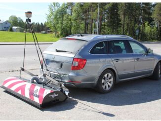
Currently autonomous vehicles with some exceptions rely on on-board sensors for the detailed aspects of navigation. But many believe that high precision maps, which contain significantly more detailed information and true-ground-absolute accuracy than current road […]
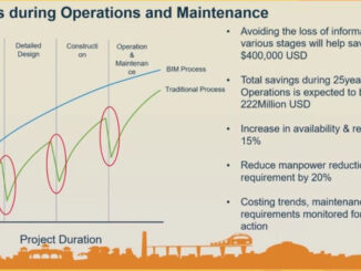
I thought it would be worth while to include here the plenary talk I gave at GeoIgnite 2019 in Ottawa about the growing evidence of the benefits of an integrated BIM + geospatial approach to […]
Press Release written by SimActive Inc SimActive Inc. announces a new drone data processing service based on Correlator3D™. Clients can now upload full projects and have SimActive experts generate optimal results from their imagery, including […]
Your Canadian Geospatial Briefing for July 9th: Radarsat Constellation imagery available to public; TSX:MAXR Up 81% in the 2ndQuarter; 5G Wireless Network for Open Innovation is Open for Business; Unattended cyber-garden, Canada’s weakness In June […]