• facebook
  • Twitter
  • Linkedin
  • Youtube
  • Linkedin Group
  • Post a Job
  • Post an Ad
  • Post an Event
  • Post a Directory Listing
  • Post a Press Release
  • Media Kit
  • My Account
  • Login
GoGeomatics
  • MAGAZINE
    • BIM & GIS
    • Community
    • Conference news
    • Earth Observation
    • Education & Careers
    • GEOAI
    • Announcements
    • Reality Capture & Lidar
    • Science
    • Technology
    • Between the Poles
  • Directories
    • ASSOCIATION
    • INDUSTRY
    • EDUCATION
    • Open Data
  • EVENTS
    • GeoIgnite Events
    • Events Calendar
    • GoGeomatics Meetups
  • Services
    • Advertising
    • Marketing
    • Post a Job
    • Post an Ad
    • Post an Event
    • Post a Press Release
    • Post a Directory Listing
    • Media Kit
    • Web Design
  • Find a Job
  • Volunteer
    • Start a GoGeomatics Group
    • Editors & Writers Group
  • About Us
    • About Us
    • Contact Us
    • Frequently Asked Questions
  • Videos
Home2019

Year: 2019

||
Technology

Your Global Geospatial Briefing for April 29th: Geospatial Mapping in Nursing; By Design; GWF workshop; 5G and Blockchain; OGC

29 April 2019 GoGeomatics Newsmakers | 5G

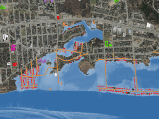
FDNY geospatial mapping used to reach opioid overdose cases Nurses and nursing students are using local, real-time maps of opioid overdoses to guide their work in community health settings. The Fire Department of New York […]

|WGIC-Logo
Newsmakers & Press Releases

WGIC announces appointment of new President and Treasurer for 2019 – 2020 term

28 April 2019 GoGeomatics Newsmakers | community

New Delhi | April 17, 2019 I Place: Amsterdam  The Annual General Meeting of the World Geospatial Industry Council (WGIC), was held on April 1, 2019 in Amsterdam. With 21 co-founders during the first formal […]

|||
Technology

Government of Canada: National Elevation Data Strategy Update with AI & Big Data

26 April 2019 David Belanger | Artificial Intelligence

Natural Resources Canada (NRCan) is increasing the HRDEM product coverage by 30,000 km2 by publishing 21 new datasets in six provinces (BC, SK, MB, ON, QC, NB). This new publication of the HRDEM product adds […]

3D data

British standard PAS128 for underground utility location to be updated

24 April 2019 Geoff Zeiss

Belgium underground gas line explosion during excavation 2003 As we are reminded by the recent underground utility hits in San Francisco, CA, Durham, NC, and Calgary, Alberta, not knowing the location underground utilities represents a […]

|
Community

5 reasons to attend GeoIgnite 2019, the Geospatial Event you don’t want to miss this June

23 April 2019 GoGeomatics Canada | Canadian conferences

GoGeomatics’s first inaugural cross-industry technology conference, Geoignte 2019, is happening June 18th -19th 2019, in Ottawa, Ontario, Canada. Managers and executives are especially encouraged to send representatives to the conference to gather experiences and understanding […]

|
Education & Careers

University of Calgary Geomathon: Geospatial Graduate Design Hack-a-thon a success

18 April 2019 Schulich School of Engineering | Canadians universities

The Department of Geomatics Engineering’s Geomatics Graduate Group (G^3) successfully organized a hack-a-thon competition for  graduate  students  in  geospatial  related  fields,  Geomathon,  for the first time in Canada. This event was part of GeoDays 2019, […]

|||
Education & Careers

PCI Geomatics Announces user-group meeting for GeoIgnite in Ottawa June 17th

15 April 2019 GoGeomatics Canada | Canadian conferences

As part of the GeoIgnite 2019 conference schedule, PCI Geomatics will host a user-group meeting, open to anyone who wishes to learn about the latest developments in PCI software, including Analysis Ready Data tools, large-volume […]

|
Newsmakers & Press Releases

New Brunswick: 1st Canadian Province to Complete Lidar Coverage with an Open Data License*

14 April 2019 GoGeomatics Newsmakers | aerial imagery

Re-posted from Bernie Connors Monday, April 8, 2019, New Brunswick releases the 2018 lidar data for public download and becomes the first Canadian province to achieve complete aerial lidar coverage under an open data license. […]

Posts pagination

« 1 … 20 21 22 … 31 »

Events

Notice
There are no upcoming events.

View All Events

Services

  • Post a Job
  • Post an Ad
  • Post an Event
  • Post a Directory Listing
  • Post a Press Release
  • Media Kit
  • My Account
  • Login

Jobs

Post a Job
  • Volunteer Editorial Contributor – Be Part of Canada’s Geomatics Story
    Remote
  • Junior Geomatics Field Technician – Technical Surveys
    Montréal, QC
  • GIS Specialist
    Amherst, Nova Scotia
  • Precast Structural BIM Specialist
    Calgary, Alberta
View All Jobs
  • Directories
    • Associations Directory
    • Industry Directory
    • Education Programs
    • Open Data
  • Volunteer
    • Start a GoGeomatics Group
    • Editors & Writers Group
  • About Us
    • GoGeomatics Media Kit
    • Who We Are
    • Contact Us
    • FAQ’s
    • Advertising
    • Marketing
  • Subscribe
GoGeomatics
GoGeomatics is the largest and most popular communications hub promoting the Canadian geospatial community. The business was incorporated in 2011. GoGeomatics hosts over 100 fun, free, location technology networking events each year in cities across Canada.

© 2026 GoGeomatics

  • facebook
  • Twitter
  • Linkedin
  • Youtube
  • Linkedin Group