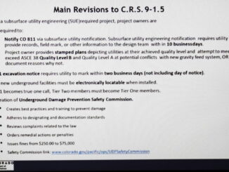
• facebook
  • Twitter
  • Linkedin
  • Youtube
  • Linkedin Group
  • Post a Job
  • Post an Ad
  • Post an Event
  • Post a Directory Listing
  • Post a Press Release
  • Media Kit
  • My Account
  • Login
GoGeomatics
  • MAGAZINE
    • BIM & GIS
    • Community
    • Conference news
    • Earth Observation
    • Education & Careers
    • GEOAI
    • Announcements
    • Reality Capture & Lidar
    • Science
    • Technology
    • Between the Poles
  • Directories
    • ASSOCIATION
    • INDUSTRY
    • EDUCATION
    • Open Data
  • EVENTS
    • GeoIgnite Events
    • Events Calendar
    • GoGeomatics Meetups
  • Services
    • Advertising
    • Marketing
    • Post a Job
    • Post an Ad
    • Post an Event
    • Post a Press Release
    • Post a Directory Listing
    • Media Kit
    • Web Design
  • Find a Job
  • Volunteer
    • Start a GoGeomatics Group
    • Editors & Writers Group
  • About Us
    • About Us
    • Contact Us
    • Frequently Asked Questions
  • Videos
Home2021

Year: 2021

Community

Optimizing and Accelerating the Globe in 3D, Maxar’s Ryan Hamilton: GeoIgnite 2021 On YouTube

17 June 2021 GoGeomatics Canada | 3D

3D mapping is continuing to advance and be crucial to our understanding of the planet we live on and how we study it. Maxar, a titan in the EO industry, is building what may be […]

Community

YouTube: “Why is an AI company designing Canada’s hydro database?”

17 June 2021 GoGeomatics Canada | AI

Vancouver-based cognitive AI company Minerva Intelligence is working on the first major update to the Canadian National Hydro Network (NHN) since 2004. AI is not typically a tool for this field, but as Jake McGregor, the […]

3D data

Colorado leads in mandating subsurface utility engineering (SUE) surveys for public civil engineering projects

16 June 2021 Geoff Zeiss

A major gap in the construction process is the unavailability of reliable information about the location of underground utilities during the design stage of civil engineering construction projects such as highways and pipelines. All states […]

Community

GeoIgnite Talk On YouTube: The National Canadian Elevation Data Strategy Update from NRCan

16 June 2021 GoGeomatics Canada | 3D

Natural Resources Canada is hard at work on the National Elevation Data Strategy, which aims to provide Canadians with an accurate three-dimensional representation of the country, in support of government priorities. This is Canada’s DEM. […]

|
Community

Calgary’s Morgan Ostrander Named Outstanding 2021 GoGeomatics Group Leader for Canada

16 June 2021 Jon Murphy | alberta

I’m excited to announce that Morgan Ostrander, GoGeomatics community leader for Calgary, is the 2021 national leadership award winner. Morgan’s outstanding efforts leading the Calgary geospatial community pre-covid, as well as during the pandemic, exemplifies […]

Newsmakers & Press Releases

Ontario Based SkyWatch raises $17.2M for its Earth Observation data platform

15 June 2021 GoGeomatics Canada | Canada

SkyWatch Space Applications Inc. (“SkyWatch“), a Waterloo-based space technology startup, announced today the completion of a $17.2M USD Series B round of financing to further democratize access to Earth observation data. Drive Capital led the investment round with […]

Newsmakers & Press Releases

ESA Advanced Training: Earth Observation & AI for Forestry

14 June 2021 GoGeomatics Newsmakers | AI

The European Space Agency (ESA) is organising an Advanced Training Course on Land Remote Sensing with the focus on Earth Observation and Artificial Intelligence for Forestry. This course is dedicated to training the next generation of Earth Observation […]

Community

GeoIgnite Talk: “The Geospatial Product Trap,” SparkGeo’s CEO – Will Cadell

14 June 2021 GoGeomatics Canada | big data

From Day One of the GeoIgnite 2021 conference comes one of the most engaging talks of the event from SparkGeo’s CEO Will Cadell. In it, he discusses the “Geospatial product trap” including what it is […]

Posts pagination

« 1 … 19 20 21 … 36 »

Events

Notice
There are no upcoming events.

View All Events

Services

  • Post a Job
  • Post an Ad
  • Post an Event
  • Post a Directory Listing
  • Post a Press Release
  • Media Kit
  • My Account
  • Login

Jobs

Post a Job
  • Volunteer Editorial Contributor – Be Part of Canada’s Geomatics Story
    Remote
  • Junior Geomatics Field Technician – Technical Surveys
    Montréal, QC
  • GIS Specialist
    Amherst, Nova Scotia
  • Precast Structural BIM Specialist
    Calgary, Alberta
View All Jobs
  • Directories
    • Associations Directory
    • Industry Directory
    • Education Programs
    • Open Data
  • Volunteer
    • Start a GoGeomatics Group
    • Editors & Writers Group
  • About Us
    • GoGeomatics Media Kit
    • Who We Are
    • Contact Us
    • FAQ’s
    • Advertising
    • Marketing
  • Subscribe
GoGeomatics
GoGeomatics is the largest and most popular communications hub promoting the Canadian geospatial community. The business was incorporated in 2011. GoGeomatics hosts over 100 fun, free, location technology networking events each year in cities across Canada.

© 2026 GoGeomatics

  • facebook
  • Twitter
  • Linkedin
  • Youtube
  • Linkedin Group