• facebook
  • Twitter
  • Linkedin
  • Youtube
  • Linkedin Group
  • Post a Job
  • Post an Ad
  • Post an Event
  • Post a Directory Listing
  • Post a Press Release
  • Media Kit
  • My Account
  • Login
GoGeomatics
  • MAGAZINE
    • BIM & GIS
    • Community
    • Conference news
    • Earth Observation
    • Education & Careers
    • GEOAI
    • Announcements
    • Reality Capture & Lidar
    • Science
    • Technology
    • Between the Poles
  • Directories
    • ASSOCIATION
    • INDUSTRY
    • EDUCATION
    • Open Data
  • EVENTS
    • GeoIgnite Events
    • Events Calendar
    • GoGeomatics Meetups
  • Services
    • Advertising
    • Marketing
    • Post a Job
    • Post an Ad
    • Post an Event
    • Post a Press Release
    • Post a Directory Listing
    • Media Kit
    • Web Design
  • Find a Job
  • Volunteer
    • Start a GoGeomatics Group
    • Editors & Writers Group
  • About Us
    • About Us
    • Contact Us
    • Frequently Asked Questions
  • Videos
Home2022

Year: 2022

||||||
Technology

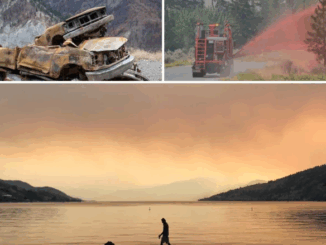
Do you know BC wildfires and floods are linked to each other?

9 June 2022 Alefiya Dungrawala | 2021 B.C Floods

British Columbia wildfires 2021 was the third-worst in its history. The towns which were on evacuation alert during summer wildfires were at flood risk in fall and winter. The flood that followed the wildfires was […]

3D data

Developing a subsurface digital twin for Singapore requires data quality management

7 June 2022 Geoff Zeiss

Singapore has severely limited land, but unlimited space and has started to build many types of activities underground to save the land above ground for the better living of citizens. Many of the traditional utilities […]

Between the Poles – The Geoff Zeiss Archives

Key initiatives of importance to the global geospatial+AEC subsurface digital twin community

6 June 2022 Geoff Zeiss

Two initiatives of importance to the global geospatial community will begin this June. Expanding Responsibility for the BetweenThePoles blog First of all we are expanding the BetweenThePoles blog from a single content provider (Geoff Zeiss) […]

||||
Technology

International Geospatial Briefing – June 6th, 2022: 1. Largest-ever imagery contract handed out by National Reconnaissance Office 2. Are Maps the next big medium? Felt is betting on it 3. Xona’s private GNSS passes critical tests on path to launch 4. New US school shooting map in wake of Texas tragedy 5. Geospatial and the problem of too much climate data

6 June 2022 GoGeomatics Canada | BlackSky

Largest-ever imagery contract handed out by National Reconnaissance Office A new announcement out of the National Reconnaissance Office in the US is now the largest-ever contract for imagery in the commercial sector. The contract, announced […]

||||||
Technology

NV5 Geospatial Supports Natural Resources Canada in Topobathymetric Lidar Survey of South and North Saskatchewan Rivers

6 June 2022 Sven Cowan | Canada

Over the last decade, a growing number of municipal and regional governments across North America have invested in topobathymetric lidar surveys of lakes, rivers and watersheds. Regional governments often commission new lidar survey projects, along […]

3D data

Standards-based subsurface data model key objective of New York’s underground infrastructure resilience project

3 June 2022 Geoff Zeiss

Improving disaster resilience requires accurate data about subsurface utility and other infrastructure. New York has has experienced several disasters over recent decades, foremost among them 9/11 and Hurricane Sandy. The experience of 9/11 and Hurricane […]

|||||
Technology

NV5 Geospatial Discusses Remote Sensing and Analytics to Support Hydrospatial Solutions

3 June 2022 GoGeomatics Canada | analytics

A “Holistic Understanding of Water in Our World” At the March 1, 2022, GeoIgnite, Winter Geo conference, Sven Cowan, Canada Program Manager at NV5 Geospatial, and Mischa Hey, Practice Lead at Analytics at NV5 Geospatial, jointly […]

||||||
Technology

MDA Introduces Its Next SAR Mission: CHORUS

1 June 2022 GoGeomatics Canada | agriculture

This Statellite Will Change How You See The World At the GeoIgnite, Winter Geo conference on March 2, 2022, during a livestream presentation, MDA Senior Director, Wayne Hoyle, introduced CHORUS, its next SAR mission. He […]

Posts pagination

« 1 … 22 23 24 … 38 »

Events

Notice
There are no upcoming events.

View All Events

Services

  • Post a Job
  • Post an Ad
  • Post an Event
  • Post a Directory Listing
  • Post a Press Release
  • Media Kit
  • My Account
  • Login

Jobs

Post a Job
  • Volunteer Editorial Contributor – Be Part of Canada’s Geomatics Story
    Remote
  • Junior Geomatics Field Technician – Technical Surveys
    Montréal, QC
  • GIS Specialist
    Amherst, Nova Scotia
  • Precast Structural BIM Specialist
    Calgary, Alberta
View All Jobs
  • Directories
    • Associations Directory
    • Industry Directory
    • Education Programs
    • Open Data
  • Volunteer
    • Start a GoGeomatics Group
    • Editors & Writers Group
  • About Us
    • GoGeomatics Media Kit
    • Who We Are
    • Contact Us
    • FAQ’s
    • Advertising
    • Marketing
  • Subscribe
GoGeomatics
GoGeomatics is the largest and most popular communications hub promoting the Canadian geospatial community. The business was incorporated in 2011. GoGeomatics hosts over 100 fun, free, location technology networking events each year in cities across Canada.

© 2026 GoGeomatics

  • facebook
  • Twitter
  • Linkedin
  • Youtube
  • Linkedin Group