• facebook
  • Twitter
  • Linkedin
  • Youtube
  • Linkedin Group
  • Post a Job
  • Post an Ad
  • Post an Event
  • Post a Directory Listing
  • Post a Press Release
  • Media Kit
  • My Account
  • Login
GoGeomatics
  • MAGAZINE
    • BIM & GIS
    • Community
    • Conference news
    • Earth Observation
    • Education & Careers
    • GEOAI
    • Announcements
    • Reality Capture & Lidar
    • Science
    • Technology
  • Directories
    • ASSOCIATION
    • INDUSTRY
    • EDUCATION
    • Open Data
  • EVENTS
    • GeoIgnite Events
    • Events Calendar
    • GoGeomatics Meetups
  • Services
    • Advertising
    • Marketing
    • Post a Job
    • Post an Ad
    • Post an Event
    • Post a Press Release
    • Post a Directory Listing
    • Media Kit
    • Web Design
  • Find a Job
  • Volunteer
    • Start a GoGeomatics Group
    • Editors & Writers Group
  • About Us
    • About Us
    • Contact Us
    • Frequently Asked Questions
  • Videos
Home2025June

Month: June 2025

BIM & GIS

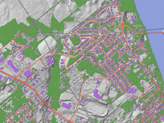
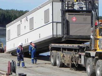
How Geospatial Technology is Used for Environmental Purposes: Vertex Case Study

20 June 2025 George Petropoulos | Abandonment & Decommissioning

Geospatial technology continues to evolve and find application across a wide range of industries, with one of its most impactful roles being in environmental protection and management. From monitoring landscapes to supporting responsible resource development, […]

Canada Map
Other

Geospatial Infrastructure: Canada’s Defense Strategy Ignores a Critical Layer

16 June 2025 Anusuya Datta | Arctic Security

Canada’s long-awaited defense policy update promises a long-overdue ramp-up in spending — reaching the NATO benchmark of 2% of GDP within a year. For a country that has historically lagged behind its allies in military […]

Intl digest june 16
Community

International Geospatial Digest June 16, 2025

16 June 2025 Volunteer Editors and Group Writers | 3D Mapping

AI Foundation Models for Earth Observation: A New Chapter in Geospatial Intelligence FAO’s upgraded ABC-Map warns of a sharp decline in Crop Suitability by 2100 Real-Time GIS Dashboards Revolutionize Emergency Response  GlobalBuildingAtlas: First Complete Open […]

Conference news

Navigating the Future: Generative AI for Enhanced Geospatial Data Quality on AWS

15 June 2025 Farzaneh Farshad | AI

At this year’s GeoIgnite conference, Amazon Web Services (AWS) delivered one of the most forward-looking presentations in the geospatial track. In a session titled “Navigating the Future: Generative AI for Enhanced Geospatial Data Quality,” Phil […]

Earth Observation

After Landsat 7: Honouring a Legacy, Continuing the Mission

15 June 2025 Benedicta Antwi Boasiako | agriculture

Every pixel tells a story. On June 4, 2025, Landsat 7 was officially decommissioned, closing out a mission that spanned more than two decades. Launched in 1999, Landsat 7 carried the Enhanced Thematic Mapper Plus […]

Allen Carrol
BIM & GIS

The Mapmaker’s Journey: Allen Carroll on Storytelling, Cartography, and His New Book

12 June 2025 Anusuya Datta | Allen Carroll

On June 10, Allen Carroll’s new book Telling Stories with Maps, was launched, shedding light on the evolving role of maps in storytelling. As the founder of Esri StoryMaps and former Chief Cartographer at National […]

Community

The New Geospatial Imperative: Luc Vaillancourt on Clarity, Value, and User-Centric Innovation

12 June 2025 Alefiya Dungrawala | BALIZ

At GeoIgnite 2025 in Ottawa, Luc Vaillancourt, founder of BALIZ, delivered one of the event’s most thought-provoking talks: “Two Solitudes in Geomatics.” Drawing inspiration from Canadian literature and culture, Vaillancourt used the metaphor of “two […]

Other

Taking Control of Canada’s Digital Sovereignty with Open-Source GIS

10 June 2025 Anusuya Datta | Canada

(This is the second part of our series, following the article exploring France’s success with open-source GIS) Canada’s geospatial systems are at a crossroads. Technology is moving fast, and the pressure is on for more efficient, […]

Posts pagination

« 1 2 3 4 5 »

Events

Feb 24
February 24, 2026 - February 26, 2026

Government Innovation Week – Federal

Feb 24
February 24, 2026 @ 10:00 am - February 25, 2026 @ 4:00 pm

Lidar CANEX 2026

Feb 25
All day

Government Cybersecurity Showcase Federal 2026

Mar 1
March 1, 2026 - March 4, 2026

PDAC Convention 2026

Mar 10
March 10, 2026 - March 13, 2026

2026 ABCLS Conference and 121st Annual General Meeting

View Calendar

View All Events

Services

  • Post a Job
  • Post an Ad
  • Post an Event
  • Post a Directory Listing
  • Post a Press Release
  • Media Kit
  • My Account
  • Login

Jobs

Post a Job
  • Canada Maps and Poster Gallery Volunteer Leads — GeoIgnite 2026
    remote
  • GIS & Data Analytics Lead
    Beaumont, AB
  • Lead Surveyor, Projects/Arpenteur-géomètre principal, projets; arpenteuse-géomètre principale, projets
    North Bay, Thunder Bay
  • Senior GIS Developer
    Calgary, AB
View All Jobs
  • Directories
    • Associations Directory
    • Industry Directory
    • Education Programs
    • Open Data
  • Volunteer
    • Start a GoGeomatics Group
    • Editors & Writers Group
  • About Us
    • GoGeomatics Media Kit
    • Who We Are
    • Contact Us
    • FAQ’s
    • Advertising
    • Marketing
  • Subscribe
GoGeomatics
GoGeomatics is the largest and most popular communications hub promoting the Canadian geospatial community. The business was incorporated in 2011. GoGeomatics hosts over 100 fun, free, location technology networking events each year in cities across Canada.

© 2025 GoGeomatics

  • facebook
  • Twitter
  • Linkedin
  • Youtube
  • Linkedin Group