
Wildfires across North America are no longer confined to a single season. Each year, they burn longer, spread faster, and shatter new records. Satellites have helped scientists track their movement and map the destruction in two dimensions—but one critical detail has remained out of reach: the height of the smoke.
A new technique using satellites creates three–dimensional maps of wildfire smoke. This innovation shows not just the location of the smoke but also its altitude in the atmosphere — key information for identifying which communities are genuinely at risk. When smoke plumes stay high above the surface, air quality at ground level may remain safe. But when these plumes come down, people breathe in harmful particles called PM2.5, which can worsen asthma and heart problems.
With 3D mapping, researchers and air quality officials can evaluate smoke exposure in specific neighborhoods, offering unmatched insight for predicting wildfires and safeguarding public health.
Why Smoke Height Matters
One of the clearest ways to understand this is through a simple example. Picture a city blanketed by what appears, on satellite imagery, to be a thick cloud of smoke. A 2D map would suggest the entire area is engulfed in hazardous air. But a 3D analysis tells a different story—the smoke plume is actually suspended 3 to 5 km above the ground, leaving the air at street level clean and safe to breathe.
Without delving into the technical details, consider the difference between 2D and 3D mapping.
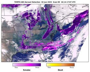
2D Mapping: Most smoke maps display only the location of the smoke without indicating its altitude. These two-dimensional maps rely on aerosol optical depth (AOD) or visible images to monitor the horizontal spread of a smoke plume. However, they cannot determine whether the smoke is situated several kilometers above the ground (which is relatively safe to inhale) or near the surface (posing a significant health hazard).
3D Mapping: By analyzing atmospheric absorption features, specifically how oxygen absorbs sunlight differently at various altitudes, scientists can now estimate smoke plume height from space. When combined with aerosol data, this enables a true 3D rendering of smoke, helping to determine not only the presence of smoke but also its proximity to the ground.
This information is crucial for deciding whether communities and affected regions require immediate alerts.
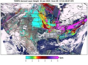
Tropospheric Emissions: Monitoring of Pollution, or TEMPO, satellite is a new method to determine the height of smoke plumes.
Tropospheric Emissions Monitoring of Pollution mission (TEMPO)
Since its launch in 2023, NASA’s Tropospheric Emissions: Monitoring of Pollution mission (TEMPO) has been monitoring the air quality from 22,000 miles above Earth. NASA satellites often operate far beyond their initial mission durations.
TEMPO measures the altitude of a smoke plume by analyzing the absorption of sunlight by oxygen molecules at the 688-nanometer wavelength. Smoke plumes higher in the atmosphere reflect more solar radiation at this wavelength back into space, while those closer to the ground, where oxygen concentration is greater and absorbs more light, reflect less.
By understanding these physical principles, scientists developed algorithms that use TEMPO’s data to estimate the height of smoke plumes and track their three-dimensional movement in near real time.
TEMPO detects trace gases linked to air quality variations resulting from smog, wildfire smoke, dust, or emissions from vehicles and power plants. These gases include nitrogen dioxide, ozone, and formaldehyde present in the troposphere, the atmosphere’s lowest layer. This represents a major advancement compared to relying solely on ground-based air quality monitoring stations, which may be located hundreds of miles apart.
Looking Ahead
Mapping wildfire smoke in 3D is more than a scientific milestone; it’s a step toward living smarter with our environment. With every orbit, satellites like TEMPO and GOES-R help turn the chaos of fire into information—and information into resilience. Advance monitoring marks a new era for better air-quality forecasting and warning the communities at risk from wildfire smoke.
More efficient allocation of resources for public health agencies and environmental authorities. Enhanced scientific understanding of smoke transport: knowing how high plumes go affects how long smoke stays aloft, how far it travels, how it disperses, and how it mixes into surface air.


Be the first to comment