
Radar technology has long been at the heart of how we observe, measure, and manage our planet. Few people have shaped that field as profoundly as Dr. Vernon Singhroy, President of EOSPATIAL Inc. and one of Canada’s foremost leaders in radar and Earth Observation.

In this article, we take a closer look at his book, Advances in Remote Sensing for Infrastructure Monitoring, and explore his insights on where radar science is heading. Building on his earlier GoGeomatics feature, A Lifetime in Radar, Dr. Singhroy reflects on decades of innovation — from pioneering RADARSAT applications to advancing today’s integrated, multi-sensor monitoring systems that define the future of geomatics.
In his edited volume, Advances in Remote Sensing for Infrastructure Monitoring, Singhroy brings together global case studies that demonstrate how radar, optical, LiDAR, UAV, and structural-geophysical techniques are transforming the way we characterize, monitor, and maintain infrastructure. This recent Springer book, with a current download count of 13,000, highlights the growing importance of remote sensing in detecting deformation, assessing asset health and intelligence, and supporting climate resilience.
The Current State of Radar for Infrastructure Monitoring
Today, Synthetic Aperture Radar (SAR) and Interferometric SAR (InSAR) technologies enable wide-area, all-weather, day-night monitoring of infrastructure deformation and movement. These methods support applications ranging from highway and railway stability to pipeline integrity and bridge monitoring and urban subsidence. Singhroy’s book also underlines the importance of data integration, combining radar with optical, LiDAR, UAV, and in-situ measurements, to achieve a more comprehensive understanding of infrastructure behavior.
Canada, through its RADARSAT programs, has been a global leader in SAR innovation. Dr. Singhroy’s contributions as Chief Scientist for the RADARSAT Constellation Mission have helped position Canadian radar science at the forefront of operational monitoring and applied geospatial intelligence.
However, despite its strengths, radar monitoring still faces certain limitations: trade-offs between spatial and temporal resolution, directional sensitivity (side-looking geometry challenges), and data-volume management. Overcoming these challenges is key to unlocking radar’s next frontier.
What’s Next for Radar — The New Science
To explore where radar technology is heading, and how it connects with emerging sensing paradigms, I asked Dr. Singhroy to share his thoughts on the future of radar science, innovation, and integration within the broader field of Earth observation and infrastructure resilience.
Your book captures radar’s evolution from mapping and deformation analysis to real-time infrastructure monitoring. Where do you see the next leap in radar science and application?
Satellites are now functioning as full-scale intelligence platforms, with radar applications expanding rapidly across defense, agriculture, climate verification, and resource exploration and infrastructure monitoring. The global SAR market is projected to grow from $5.7 billion in 2025 to $9.8 billion by 2030—driven by demand for persistent monitoring and decision-ready data.
Over the next five years, key missions will shape the next leap in radar science. These missions are the CSA’s RCM follow-on and MDA’s Chorus C and X for maritime surveillance and disaster intelligence, ESA’s Sentinel ID and ROSE-L, plus commercial constellations like ICEYE, Capella, and Umbra. The new science expected from the advanced frequency and polarimetric capabilities from NISAR, ESA’s P-band biomass mission, ALOS-4, and more compact polarimetric applications of RCM will improve many application
These systems will deliver integrated SAR solutions—combining hardware, software, and AI-powered analytics—to enable real-time signal processing and faster operational decisions across many sectors.
While this interview focuses on infrastructure, it’s worth noting that Canada’s radar science leadership also extends to climate and ecosystem monitoring through agencies like Environment Canada, Agriculture Canada, the Canadian Ice Centre and Fisheries and Oceans, Canada
Many of your chapters discuss Interferometric and polarimetric techniques. Looking forward, how do you see radar evolving beyond traditional polarimetric metrics — perhaps toward advanced data?
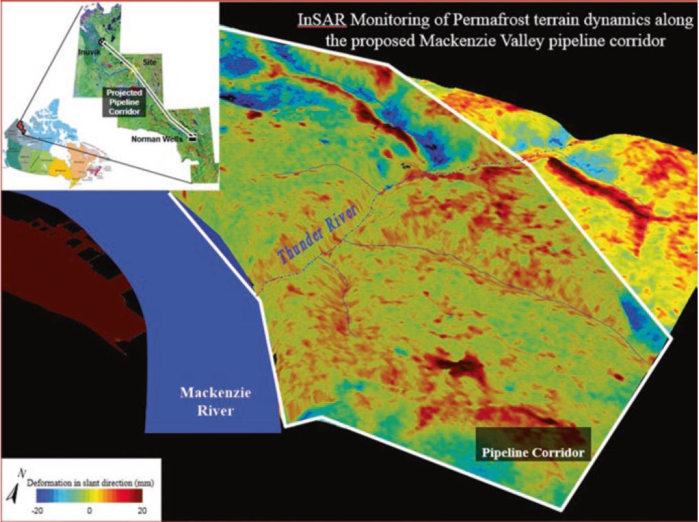
Advanced interferometric methods are transforming how we monitor infrastructure. InSAR provides millimeter-level motion detection from space, offering wide-area, non-invasive coverage for critical assets like pipelines, bridges, ports, runways, and mine sites, including Canada’s Ring of Fire.
This capability is especially vital in northern Canada, where melting permafrost threatens structural stability of our infrastructure. As chief scientist of the RADARSAT Constellation Mission (RCM), we successfully launched a system that delivers high-resolution InSAR data every four days—ideal for tracking deformation in areas targeted for development and mining.
Looking ahead, the newly launched US–India NISAR mission will complement RCM with L-band InSAR, offering centimeter-level motion detection every 12 days. The L-band’s deeper penetration and improved coherence make it highly effective in our vegetated and frozen northern terrains.
Polarimetric Interferometry (PolInSAR) adds another layer of insight by using full polarization data to distinguish surface properties. In Canada, PolInSAR has already been applied to monitor land subsidence and bridge stability. We’re expanding its use for routine infrastructure monitoring and environmental applications, including crop health, forest biomass, and wetland dynamics—supporting sustainable land use across several federal research programs.
Together, RCM, INSAR, and PolInSAR represent a new era of radar intelligence—one that enables predictive maintenance, risk mitigation, and resilient infrastructure planning at local and national scale.
Your book highlights the integration of radar with optical, LiDAR, and UAV data. How do you envision future systems combining these sources — moving toward what some describe as “hypospectral” or multi-modal sensing that merges spectral, spatial, and physical information into a single framework?
Multi-frequency SAR (X, C, L, and P bands) provides different levels of surface penetration and sensitivity, improving image classification, deformation tracking, and change detection. Machine learning now allows seamless fusion of radar with other imaging sources, enabling smarter analysis for mining, infrastructure, and environmental monitoring. In addition, recent advances in drone-based SAR add a new layer of high-resolution data for local site assessments.
One of my Ph.D. students at the University of New Brunswick used machine learning to identify geological structures at an impact site using SAR and other imaging data—a method that could also support lunar exploration. We have also applied similar multi modal fusion techniques in the Sudbury mineral district to locate critical minerals. Looking ahead, multi-modal sensing will evolve into unified platforms that scale these capabilities for mining, infrastructure, and planetary science.
Innovation today often lies in how data is processed and applied. In your view, where does the true innovation in radar now reside: in sensor hardware, advanced analytics, or the fusion of radar data with AI-driven models and digital twins for infrastructure resilience?
These are some innovations related to infrastructure resilience
- High resolution rapid revisit from RCM, enables near real-time monitoring.
- AI-assisted interpretation of multifrequency and polarimetric radar signals improve the accuracy in target detection and classification.
- Multimodal sensor fusion, combining radar with optical, LiDAR, and GNSS data provide comprehensive situational awareness.
- High resolution multifrequency 3D modeling and digital twins, powered by machine learning can predict infrastructure performance and risks.
From a Canadian perspective, the integration of RADARSAT and RCM InSAR data with upcoming NISAR L-band imagery will be pivotal. These systems, enhanced by AI, will support predictive maintenance and risk assessment for major infrastructure and mining projects across the country.
Canada has played a major role in advancing radar through programs like RADARSAT. What kinds of policy frameworks or international collaborations do you believe are needed to sustain innovation and ensure that advanced radar technologies continue to support both science and society?
Canada’s leadership in radar innovation — through RADARSAT and the RADARSAT Constellation Mission (RCM) has delivered critical capabilities for climate verification, infrastructure and ecosystem monitoring, disaster response, and maritime surveillance. To sustain and expand this impact, we must modernize our policy, deepen international collaboration, and accelerate industry innovation. We should
- Embed Earth Observation (EO) and InSAR into infrastructure planning, environmental assessments, and climate adaptation strategies. Mandate their use in federal risk evaluations.
- Establish Radar–EO–AI innovation hubs that unite hardware engineers, software developers, and regulators to co-develop scalable solutions.
- Launch exchange fellowships for Canadian EO researchers and engineers to work in leading radar labs worldwide—and welcome global talent into Canadian institutions.
- Increase funding for EO startups focused on infrastructure resilience, agricultural analytics, and maritime domain awareness using SAR technologies.
Canada’s radar legacy is strong. With bold policy, strategic partnerships, and targeted investment, we can ensure it continues to serve science, society, and sovereignty for decades to come.
Closing: The Next Horizon for Radar
As Dr. Vernon Singhroy’s reflections reveal, radar is entering a new scientific frontier with improved sensors and higher resolution. The “new science” of radar lies in its convergence with optical, LiDAR, hyperspectral, and AI-driven systems, transforming raw backscatter into actionable foresight for infrastructure resilience, environmental stewardship, and planetary exploration.
Canada’s leadership, anchored in decades of innovation from RADARSAT to RCM and beyond, offers a foundation for global collaboration and technological renewal. Yet the next horizon depends on how boldly we connect science with policy, research with industry, and satellites with the societies they serve. In this evolving landscape, radar is no longer just a remote-sensing tool, it is becoming a strategic instrument of sustainability and preparedness for the challenges ahead.


Be the first to comment