
We are excited to be speaking with Lee Morden, a geomatics instructor at SAIT in Calgary, Alberta. He is committed to expanding his knowledge in geomatics and education in support of providing quality training to post-secondary students and geomatics industry members.
![]()
Jonathan Murphy: Hi Lee, and welcome to the GoGeomatics Canada community. We like to start with a “get to know you” first. Where are you from and where did you get your geomatics education?
Lee Morden: I am originally from southern Ontario by way of Saskatchewan, but I got my Geomatics education at the University of Calgary.
Jonathan Murphy: Why did you decide to pursue a career in geomatics?
Lee Morden: At the time, I had been working in the livestock industry and I was looking for an opportunity to re-focus my career. I could see that geomatics was a rapidly expanding industry with a broad range of applications.
Jonathan Murphy: You have been training and instructing people in geomatics for over ten years. What has made you so passionate about sharing your expertise and passion for geomatics with others?
Lee Morden: Personally, I love learning. I am excited to discover new ideas and re-discover some older concepts. When I worked in the geomatics industry, my best days were spent in the field with a survey crew who were learning new equipment or developing new skills. Helping people to expand their knowledge and skill sets is very rewarding. Knowing that new tools and skills will help them to do their job more efficiently or will create opportunities to work on different projects and lead to career advancement is a way that I can contribute both individually and collectively to society.
Jonathan Murphy: SAIT has several geomatics programs. There is a geomatics engineering technology program and a geomatics certificate of achievement. Can you describe them and how they differ from each other?

Lee Morden: The 2-year geomatics engineering technology program leads to a diploma. We enroll 64 students each September. Class sizes are limited to 32 students and the labs are divided into groups of 16. This ensures that we can provide effective support to the students and give them good opportunities for practical hands-on learning. The diploma program is accredited with Technology Accreditation Canada (TAC) and is recognized by ASSMT (Alberta Society of Surveying and Mapping Technologists) among other associations.
The diploma program also provides opportunities for our students to continue their education through CBEPS (Canadian Board of Examiners for Professional Surveyors), and programs at BCIT (British Columbia Institute of Technology), UNB (University of New Brunswick), University of Calgary, MUN (Memorial University of Newfoundland), NAIT (Northern Alberta Institute of Technology) and TRU (Thompson Rivers University). Several our graduates also continue into the Bachelor of Geographic Information Systems program at SAIT.
The geomatics certificate of achievement is a continuing education program with an ongoing intake. It consists of 8 classes which can be completed over a period of 5 years. These classes are delivered on-line or in the evenings. A small number of students take advantage of the flexibility of this program to increase their skills without having to quit work to do a full-time program.
Jonathan Murphy: What makes the SAIT geomatics program special?
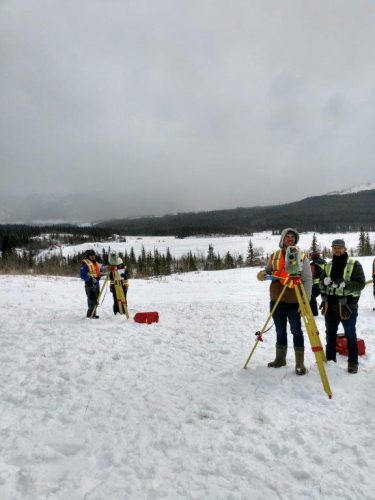
Lee Morden: The program has a core of traditional surveying skills, but we decided to enhance our existing expertise in the areas of spatial data and visualization. Our 3D modeling (laser scanning), remote sensing, and photogrammetry courses ensure that our students have substantial exposure to data acquisition, processing, and visualization across new and expanding technologies. Two of our instructors are licensed UAV pilots and we have a multi-rotor UAV that is used to acquire data for courses and Capstone projects.

The Capstone technical project in the 4th semester gives our students an opportunity to explore an area of interest and apply the available tools and techniques in self-directed study. Some examples of recent projects include a laser scan and creating a model of an indoor mountain biking park, remote sensing for forest fire fuel type classification, and using smart phone cameras to create accurate 3D models.
Despite embracing new and emerging technologies to support future opportunities for our students we also provide a solid core in geodesy and legal surveying. We work to develop an understanding of the theory underlying the technologies that we use. We want our graduates to be able to solve problems within projects and troubleshoot issues with software and equipment beyond just using a tool within a specific task. We hope that this balance equips our graduates with the skills valued by employers in the current job market and gives them the foundation to grow in their careers as the industry changes.
Jonathan Murphy: Studying geomatics/surveying can lead to a rewarding career not just in Alberta but in many parts of Canada and around the world. What types of opportunities can graduates expect after completing the 2-year geomatics program at SAIT?
Lee Morden: Many of our graduates will choose to work in the traditional surveying industry across Canada. Party chiefs and CAD specialists continue to be in demand. In addition, the breadth of our program supports opportunities for graduates to work in UAV and laser scanning data acquisition and processing, as GIS technicians in survey firms, and to continue their education in an area of interest.
Jonathan Murphy: How do you keep your program current with technologies and industry practices so students are getting the very best geomatics education?
Lee Morden: We are fortunate to have the support of industry through our Program Advisory Committee which represents a broad range of companies in the geomatics industry. The committee meets regularly, and we use small and large group discussions to examine the course objectives, materials, and assessments to ensure that we are representing industry best practices and meeting industry needs. Our instructors regularly pursue professional development opportunities to keep our knowledge and skills current with industry best practices and workflows. Our strong relationships with software providers such as MicroSurvey ensure access to software that is up-to-date and relevant, and with Spatial Technologies who support our acquisition and implementation of Leica total stations, GNSS receivers and laser scanners help to keep the program tools current.
Jonathan Murphy: What makes an ideal geomatics student for your program? What type of background and skills should they have before they enter?
Lee Morden: I’m not sure that there is such a thing as an ideal student. Every student brings their own skills and prior experience to the learning environment and together we build the knowledge and skills that will prepare them for the job market. It certainly helps for the student to be comfortable with computers, have strong math skills, and to be ready and willing to work in outdoor environments.
Jonathan Murphy: How much time do students spend in the class room and how much do they spend hands-on in the field or using equipment? What geomatics equipment and software does the SAIT program use to support teaching?
Lee Morden: The students spend about 32 hours a week in scheduled class time. Of that time between 6 and 8 hours is spent in the field performing surveying projects or processing the field returns. Approximately another 10 to 12 hours is working with software, across several courses, to solve geomatics problems. We pride ourselves on providing applied education and implement a variety of teaching methods to engage students in projects that reflect industry tasks. We use Leica 1201 and Builder total stations with CS15 controllers running Microsurvey FieldGenius, GS14 GNSS receivers with CS20 controllers running Captivate field software, C10 and BLK360 laser scanners, and DNA03 precise levels. Our office software includes AutoCAD, Civil 3D, ESRI ArcGIS, MicroSurvey inCAD, MicroSurvey Starnet, Leica Infinity, ENVI, SOCET SET, Blue Marble Geographic Calculator, and more.

Jonathan Murphy: Is there a co-op part of the program or work placement for students? How does SAIT geomatics connect graduates to industry? What is your placement rate after graduation? We’ve heard it’s quite good.
Lee Morden: There is no co-op or practicum component to our program. As for connecting graduates to industry, it is the student club that facilitates opportunities for networking. The volunteers in the student club organize a weekly speaker series and an annual Industry Night. We see strong representation from both local companies and multi-national organizations operating in the geomatics industry. The graduate employment survey indicates that, 6-months after graduation, about 90% of our graduates are employed in an area related to their education.
Jonathan Murphy: What are the job prospects like for graduates of your program? What does the Geomatics job market look like today?
Lee Morden: Job prospects are still relatively strong for our graduates. Over the last couple of years, with the slower economy particularly in the oil and gas sector, there have been fewer jobs for students during the summer between the first and second years. However, we are seeing continued and increasing interest in our graduates through job postings, recruiting visits from companies and participation in Industry night as well as our employment rates in surveys of recent graduates.
Jonathan Murphy: We appreciate you taking the time to talk to GoGeomatics Canada and discuss your program.
Lee Morden: Thank you for the opportunity to profile our program. We are very proud of the direction that we have taken over the last few years and feel that we offer one of the best programs in Canada. To learn more about the SAIT geomatics program click here.


Be the first to comment