
Year 2023 has witnessed the most devastating wildfire season that Canada has experienced in recent history. An unprecedented amount of damage has been inflicted on ecosystems and surrounding boreal communities, resulting in massive quantities of CO2 being released into the atmosphere.
As wildfires intensify in scale and frequency across Canada, the need for more precise, predictive tools has never been greater. In response, researchers have unveiled CanadaFireSat — a cutting-edge, AI-powered wildfire forecasting system that harnesses the power of high-resolution geospatial data to anticipate fire outbreaks before they escalate.
Drawbacks of Conventional Fire Forecasting
In Canada, traditional wildfire forecasting depends significantly on broad-scale environmental data, including weather predictions and past fire trends. Although these methods have been beneficial, they are inadequate in regions where factors like terrain, vegetation, and microclimates significantly influence fire behavior.
What are the drawbacks?
- Low spatial resolution (approximately 1 km or less), which masks important local variations.
- Insufficient incorporation of multispectral and topographic information.
- Inadequate use of real-time satellite imagery.
As the risks of wildfires become more localized and variable, there is a growing need for a more precise, rapid, and intelligent approach.
Advanced Solution: CanadaFireSat
Created by a group of Canadian researchers between 2024 and 2025, CanadaFireSat is a forecasting system that utilizes deep learning and high-resolution remote sensing data from various sources to predict wildfires with a high level of precision.
Talking about the key features, it consists of data fusion, deep learning algorithms, and predictive outputs:
Data Fusion:
The research has primarily used data that combines three powerful sources.
- Sentinel-2 L1C imagery: 10-20 m resolution multispectral satellite data capturing vegetation, soil moisture, and burn scars.
- MODIS (Moderate Resolution Imaging Spectroradiometer): Real-time thermal and optical data for broad spatial context.
- ERA5- Land (Climate Reanalysis): High-quality atmospheric and climate data from ECMWF, offering variables such as temperature, humidity, and wind speed.
Fire data samples in the CanadaFireSat dataset are identified based on the fire polygons of the National Burned Area Composite (NBAC) from the Canadian National Fire Database. NBAC has been compiled annually since 1972 and integrates data from Natural Resources Canada, provincial and territorial agencies, and Parks Canada, using a rule-based approach to select the most accurate burned area perimeter delineations based on post-event satellite imagery.
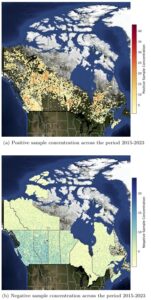
Positive samples for the CanadaFireSat dataset are extracted from the fire polygons through two aggregation processes: spatial aggregation and temporal aggregation.
The negative samples are calculated from all fire weather conditions for each region and year, including cases where a high fire weather index (FWI) was predicted, but no fire was observed.
In the map on right, the spatial distribution of the sampled negative locations across all years. It shows that, per region, the negative samples are well spread spatially, contrary to the positive samples. British Columbia, Alberta, Saskatchewan, and Manitoba contain the highest concentration of negative samples in certain areas due to the high concentration of fires in those regions (negative samples are sampled twice as much as positive ones).
In contrast, Nunavut, Newfoundland and Labrador, and New Brunswick are less densely sampled due to a lack of fires during the analyzed period.
Deep Learning models
Forecasting wildfire at the resolution of 100m using CanFireSat dataset; two deep learning models were utilized.
- Convolutional neural networks
- Transformer
The encoding from these models were able to predict wildfire at an 8-day horizon. , The models are trained in three different settings: satellite images only (Sentinel-2), environmental predictors only (ERA5, CEMS, MODIS), and when both satellite and environmental data are available.
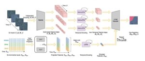
Predictive Output
Two types of predictors are used on CanFireSat dataset.
- Satellite image time series
- Environmental predictor
A high-resolution fire risk map identifying areas with high likelihood of fire occurrence in the short term (1–5 days out), updated dynamically with incoming satellite and climate data.
What were the Key Findings?
A significant advancement of this study lies in the utilization of multi-spectral and multi-temporal satellite data, with a particular emphasis on indices derived from Sentinel-2 imagery. The following indices are employed:
- NDVI (Normalized Difference Vegetation Index), which evaluates the health of vegetation;
- NDWI (Normalized Difference Water Index), which measures the water content within vegetation;
- Tasseled Cap Wetness, which indicates the moisture levels at the surface;
- Channel Histograms, which capture the distributional characteristics across various spectral bands.
These indices function as early indicators of potential environmental stressors. For instance, signs of vegetation stress or reduced moisture levels may serve as precursors to an increased risk of wildfires, potentially weeks prior to the occurrence of ignition events.
What does the future entail?
To date, most wildfire predictions have lacked the precision necessary for tactical planning. The CanadaFireSat initiative signifies a significant advancement in this field by providing predictions with a better resolution, utilizing deep learning techniques to adapt to dynamic, real-world conditions, and exhibiting the ability to generalize across previously unobserved fire seasons.
This development has the potential to enhance the capabilities of Canada-wide national agencies, forestry managers, and emergency responders by offering more detailed risk assessments, thereby facilitating earlier interventions and more efficient resource allocation.
The CanadaFireSat initiative shows that the fusion of satellite and environmental data, paired with modern AI, can produce highly detailed, reliable wildfire forecasts. As climate-driven wildfires threaten more regions, tools like this will be critical in protecting ecosystems, property, and human lives.


Be the first to comment