
Fall 2023

LIDAR ACQUISITIONS 2023 IN SUPPORT OF THE FLOOD HAZARD IDENTIFICATION AND MAPPING PROGRAM (FHIMP)
Since 2021, Natural Resources Canada (NRCan) has been leading the Flood Hazard Identification and Mapping Program (FHIMP) in partnership with Environment and Climate Change Canada and Public Safety Canada. Under this program, the federal government, in partnership with provinces and territories, are currently deploying a joint action plan to advance flood hazard mapping in highest-risk areas.
NRCan and the provinces and territories are continuing their efforts to acquire airborne LiDAR data in support of the FHIMP. This accurate, up-to-date, three-dimensional data is essential for the creation of flood hazard maps and for regional flood modelling.
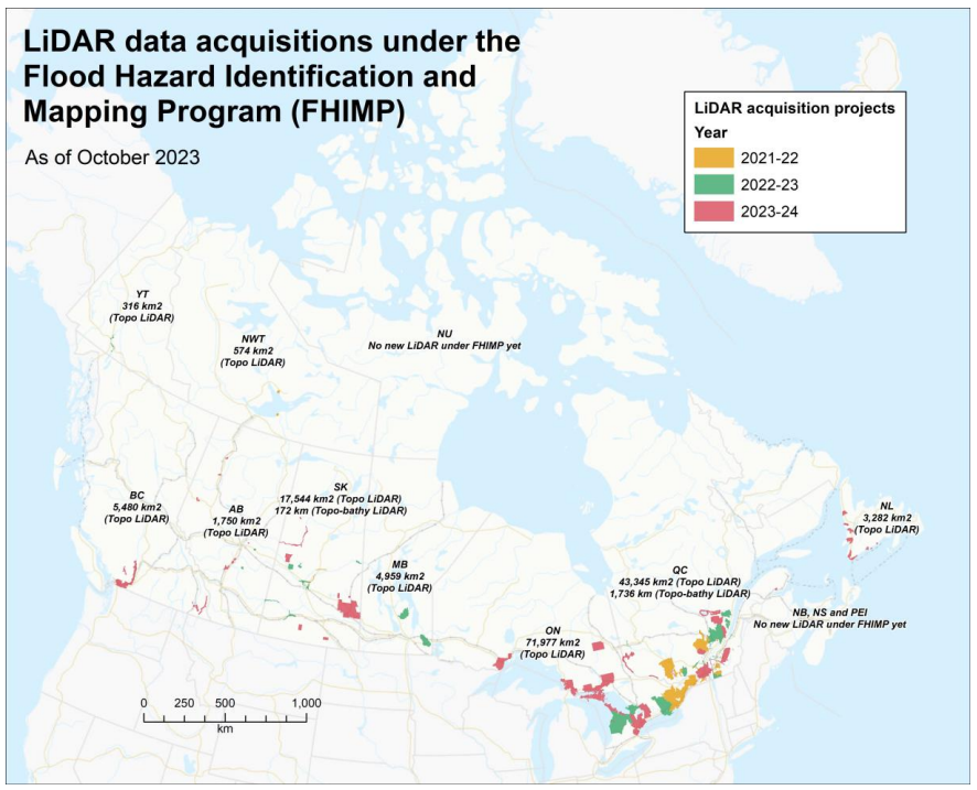
In 2023, 11 LiDAR acquisition projects will have been completed, for an additional coverage of approximately 80,000 km2 . These projects are located in flood-risk areas in the provinces of Alberta (AB), British Columbia (BC), Newfoundland and Labrador (NL), Ontario (ON), Quebec (QC) and Saskatchewan (SK).
These acquisitions include densely populated regions such as the Greater Toronto Area (ON), the Communauté métropolitaine de Montréal (QC), and the Lower Mainland (BC).
It is expected that after the first three years of FHIMP (2021 to 2023), a total of 29 LiDAR acquisition projects will have received funding from the program for a total coverage of 150,000 km2 . All of these data are aligned with the standards of the Federal Airborne LiDAR Data Acquisition Guideline and will be integrated with existing Open Maps products to be made freely available to all Canadians. In addition to being used for flood hazard mapping, this data will be useful to Canadians in a wide range of fields.
With the extension of FHIMP until 2028, LiDAR acquisitions in areas at risk of flooding will continue.
OVER A MILLION SQAURE KILOMETERS OF LIDAR-DERIVED ELEVATION DATA NOW AVAILABLE
Our elevation datasets are growing! Check out the updates in our four main elevation products below following the last release in October 2023.
High Resolution Digital Elevation Model Products (HRDEM)
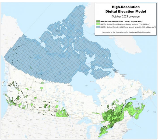
Over 244,000 km2 of LiDAR-derived elevation data have been released on Open Maps to add to the HRDEM and HRDEM Mosaic products. This new release is surpassing a milestone of 1,034,000 km2 !
With this new data release, over 36.6 million Canadians–92% of the population—lives within the region covered by the HRDEM and HRDEM Mosaic products. Now, 95 of the country’s 100 largest cities are covered by these two products. The LiDAR data used comes from many governments across the country, as well as from acquisition projects performed by NRCan over 2022, including through funds from the FHIMP.
Automatically Extracted Buildings
Nearly 6 million new LiDAR-derived building footprints have been added to the Automatically Extracted Buildings product. This new release has more than doubled the amount of building footprints in the dataset, for a total of over 9.6 million footprints! These footprints are automatically generated using LiDAR point clouds. Each footprint contains information such as elevation and minimum and maximum building heights.
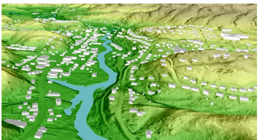
In addition, an attribute providing an estimate of the quality of the building footprint has recently been added. This estimate is based on the quality and specifications of the LiDAR data used to generate the product. For more information on this new attribute, please refer to section 7 of the product specification.
LiDAR Point Clouds
This release covers over 70,000 km2 of new LiDAR point cloud data, for a total of 130,000 km2 in the product. The release includes completed LiDAR projects partly acquired through funds from the FHIMP, including contracts managed by NRCan.
A CANADIAN HYDROSPATIAL NETWORK ALIGNED WITH ELEVATION DATA
The Canadian Hydrospatial Network (CHN) is set to replace the National Hydrographic Network (NHN) for Canada. It is produced by the Canada Centre for Mapping and Earth Observation (CCMEO) at NRCan.
The CHN is an analysis-ready network that includes not only flow lines, surface water polygons, and hydro nodes, but also has a layer of catchments and a series of value-added attributes allowing network traversing and hydrospatial analysis. The CHN leverages the HRDEM where it is available to create a hydro network aligned with high resolution elevation.
The CHN can be created in three main ways:
- automatically extracting, and then validating and correcting features from high resolution elevation and imagery
- integrating provincial and territorial hydrospatial networks when these have already been derived from high resolution elevation and imagery
- converting NHN flow lines and surface water polygons and extracting catchments from a lower resolution elevation source.
Where HRDEM is available, the CHN flow lines and catchments are automatically extracted, validated, and corrected using this elevation source. Where high resolution satellite or ortho imagery is available, surface water polygons are either extracted using GeoAI or are converted from existing Provincial / Territorial hydro networks. The CHN is able to achieve an approximate horizontal accuracy of 1-3 metres where both high resolution elevation and imagery are available. In regions that do not yet have HRDEM or high resolution imagery, it may also be possible to convert NHN features to CHN to provide full network coverage in Canada more quickly, however, the features and many attributes of the data will not be as precise or accurate.
For more information please visit: https://natural-resources.canada.ca/science-and-data/science-and-research/geomatics/topographic-tools-and-data/canadian-hydrospatial-network/25283
PREDICTION OF AIRBORNE TOPO-BATHYMETRIC LIDAR SURVEY
In support of the FHIMP, NRCan, the Ministère de l’Environnement, de la Lutte contre les changements climatiques, de la Faune et des Parcs du Québec (MELCCFP) and the Ministère des Ressources naturelles et des Forêts du Québec (MRNF) are currently deploying a joint action plan to acquire airborne topo-bathymetric LiDAR (TBL) data over major rivers in southern Quebec. TBL technology is used to simultaneously obtain a detailed representation of both emerged and submerged terrain, which are essential components of flood hazard maps. While TBL has proven effective in shallow coastal water, sensor performance in Canadian inland rivers is much less documented, presenting a notable degree of uncertainty.
To reduce risk, prioritize survey areas and improve survey monitoring, we investigate how in situ, earth observation (EO) and hydraulic index methods can help us identify which rivers are likely suitable for TBL acquisitions. Databases of historiccal in situ turbidity measurements are used to draw a broad portrayal of seasonal turbidity variations in several southern Quebec watersheds that are targeted for TBL acquisition and allow the identification of the best potential acquisition windows for each river. In situ and survey data from recent TBL acquisitions are used in a retrospective analysis to determine if successful riverbed detection could be predicted using EO-based methods such as Secchi Disk Depth (SDD) estimation or the Normalized Difference Turbidity Index (NDTI). Hydraulic index methods considering parameters such as reach slope and stream flow are also being investigated.
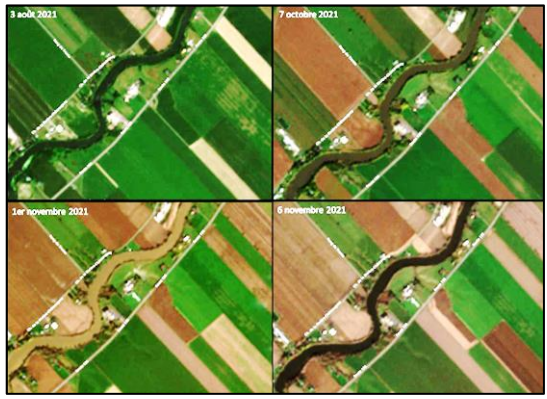
This research is led in partnership with the University of Sherbrooke and Laval University researchers specialized in EO and hydraulics. While this effort is ongoing, we aim to identify the best way to predict TBL survey success in different river environments, and eventually assess the potential of major rivers in Canada for TBL acquisitions.
Do not hesitate to provide us with comments and concrete examples of how you use the data. This helps us to stay relevant and demonstrate the importance of the strategy. You can email us at:
The authors of the articles are:
- David Bélanger
- Colleen Fuss
- Guillaume Légaré-Couture
- Danial Mariampillai
- Charles Papasodoro
- Pierre Tardif


Be the first to comment