
UWindsor researcher maps which Windsor neighbourhoods need help accessing vaccines
Research by Carina Luo, a geospatial data analyst at the University of Windsor shows there are service gaps in vaccine availability across Ontario. Some areas in Windsor-Essex with a large number of 40 and older residents and low-income population have no clinic offering a COVID-19 vaccine within walking distance.
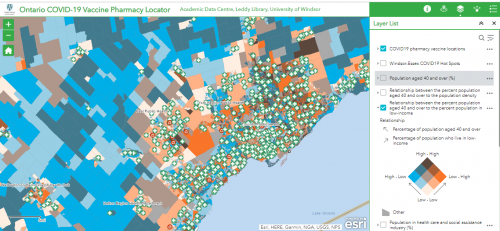
Luo also created an interactive map to visualize service gaps in vaccine availability across Ontario called Ontario COVID-19 Vaccine Pharmacy Locator. People can use this web application to find their local pharmacies offering the COVID-19 vaccine. Moreover, the tool provides access to demographic information in each neighbourhood which allows users to overlay vaccination location with demographics.
Read more here
Canada’s first 5G drones fly over UBC
Canada’s first unmanned aerial vehicles with a 5G signal transmitter-receiver performed precise flight manoeuvres at the University of British Columbia (UBC). These UAVs used UBC’s 5G network, installed by Rogers as part of a multiyear collaboration to pursue 5G research. Also, the drones accomplished some tasks such as picking up and dropping off a medical first-aid supplies box at a specified location.
UBC’s partnership with Rogers has further developed our campus as a living lab concept, enabling our researchers and partners from the public and private sectors to explore and develop real-world 5G applications with positive social as well as potential economic impacts.
Dr. Gail Murphy, vice president, research and innovation at UBC
Read more here
Arianne Phosphate partners with Quebec Center of Geomatics to apply AI & remote sensing to future Lac à Paul tailings dam
Arianne Phosphate, a development-stage phosphate mining company, partnered with the Quebec Center of Geomatics (CGQ), a group within the College of Chicoutimi, in the Province of Quebec, to further a new method to use geomatic and remote sensing instruments combined with artificial intelligence.
The research is funded by the Natural Sciences and Engineering Research Council of Canada (NSERC). It is during the construction process that sensors will be built throughout the tailings dam that will measure moisture, pressure, etc. This work will utterly promote the safety aspects of Arianne’s operations.
Read more here
UBC prof uses Sim City-like program to map disease paths
The Department of National Defence has announced its investment in Framework for Reconstructing Epidemic Dynamics (FRED), a computer program that models how a disease spreads throughout a population.
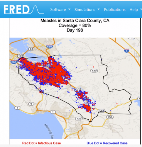
Frank Wood, the associate professor of computer science at the University of British Columbia, has received $199,985 from Innovation for Defence Excellence and Security. He is programming Canadian population data into this software.
RED is the first open-source epidemic model designed to use the latest synthetic US population developed by the Research Triangle Institute (RTI, is a non-profit based out of North Carolina).
According to a paper published by BMC Public Health and funded by the National Institute of Health and the Bill and Melinda Gates Foundation
Read more here
Remote sensing map of Canada’s first highway to the Arctic completed
In one of the biggest non-military remote sensing project of its kind, Alaska Center for Unmanned Aircraft Systems Integration (ACUASI) team used a remotely piloted SeaHunter aircraft to take over 60,000 overlapping aerial images of the Inuvik-Tuktoyaktuk Highway, Canada’s first all-weather road to the Arctic and a large stretch of the adjoining Dempster Highway.
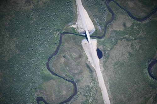
The new two-lane highway is crossing many rivers that support fish populations integral to Indigenous communities in the region.
With the support of the local Fisheries Joint Management Committee and Government of Northwest Territories, Fisheries and Oceans Canada was excited to utilize the SeaHunter as an opportunity to test remotely piloted systems in Canada’s north, where access can be limited.
Carolyn Bakelaar, a regional GIS coordinator for Fisheries and Oceans Canada Department
Read more here


Be the first to comment