Canadian Geospatial Briefing June 20th: 1. TCarta Opens Canadian Affiliate Office; 2. Canada and Denmark create world’s newest land border; 3. The Local News Map; 4. Comprehensive map of Canada’s cities for accessibility; 5. Vulnerability to rising temperatures by neighborhood.
1. TCarta Opens Canadian Affiliate Office to Provide Hydrospatial Mapping Services Across Canada
TCarta Marine, a global provider of hydrospatial products and services, has announced the formation of TCarta Canada, based in Ottawa, Ontario. Its first contract – a pilot project to update bathymetric navigation charts for Baffin Island’s Cape Hooper and Kangok Fjord with satellite-derived bathymetry (SDB) technology. The contract is administered by Canadian Hydrographic Services, which has previously purchased SDB maps from TCarta.
TCarta Canada would like to speed up research and push the boundaries for how they deliver marine geospatial products. “The Canadian Arctic is an enormous area, difficult to access, often covered in cloud, ice, and darkness, and poorly mapped,” said Knudby. Maritime traffic is increasing as the Arctic Sea ice is melting, and mariners crossing these waters need up-to-date information for safe navigation. TCarta Canada will play an important role here, turning satellite imagery into the information products that mariners need. Read more here
2. Canada and Denmark create the world’s newest land border on tiny Han’s Island
On June 13, 2022, Canada and Denmark finally decided to split Hans Island and define the rest of the disputed maritime border.
The dispute over Hans Island a.k.a Tartupaluk, emerged in the early 1970s, when Canada and Denmark agreed on most of their maritime border, the first-ever drawn up with the help of a computer, with the notable exception of Hans Island, right in the middle of the Kennedy Channel, which both claimed as their own.
Hans Island is right in the middle of the Kennedy Channel. The agreed border is between markers 122 and 123. Source: Newest land border
This newest land border is about 3/4 mile (1.2 km) long and mirrors a gorge that runs across the island from north to south. Read more here
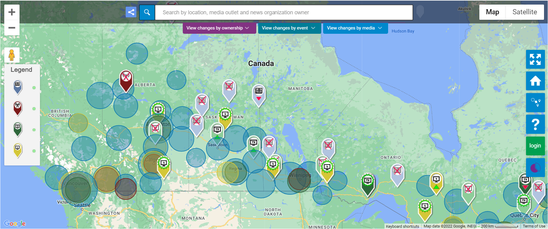
3. The Local News Map
The Local News Map is a crowd-sourced resource that keeps an eye on what is happening to local newspapers, broadcast outlets, and online/digital news sources in places across Canada.
It displays information on the launch/closing of local news organizations along with service increases/reductions going back to 2008. Map data are downloaded and analyzed in reports that are published every two months.
4. Deep data dive creates a comprehensive map of Canada’s cities for accessibility
Russell Copley’s master thesis on accessibility issues in numerous buildings across Canada has triggered new research which helped them find out that there is no authoritative data available at present on accessibility. Under his master’s thesis, Copley set up a plan to map the accessibility of businesses in major cities as well as some rural municipalities in the province of Alberta.
Personally, Copley sees the importance of building cities and communities that include everyone and are easily accessible, and truly reflect the values of living in a democratic society where people are different.
At a national level, hopefully, this kind of thesis work can help solve accessibility issues by doing budgetary investments such as installing automatic doors which is an easy fix. This can dissolve a bunch of accessibility issues to some extent. In addition to this, railing on-ramps and stop-gap ramps are other investments that can make the facility approachable to a wider level at various places. Read more here
5. Vulnerability to rising temperatures may depend on your neighborhood
Is Canada ready to cope with 21st-century heat? Temperatures that were mostly unthinkable, have become a reality in the temperate city of Vancouver.
Vancouver’s surface temperature map shows hotter and cooler areas.
This is particularly not good news for the Downtown Eastside. It’s already among the city’s hottest neighborhoods, according to a review of satellite-derived land surface temperature data. Walking through the Downtown Eastside, you notice that buildings almost entirely cover many lots, leaving little room for trees and grass. Also, neighborhoods closest to the Pacific Ocean have milder temperatures.
Montreal’s surface temperature map shows cooler patches close to the river and hotter patches in the center of the city.
Similarly, in cities like Toronto and Montreal, places with dense vegetation and trees show cooler temperatures than areas with more commercial buildings, parking lots, and fewer trees around. Neighborhood areas of the St. Lawrence River have comparatively lower temperatures compared to the packed-up industrial and commercial zones.
Toronto’s surface temperature map shows cooler areas close to the water and hot areas in the city.
Urbanization in big cities has resulted in a concrete world that heats up faster. Mapping heat vulnerability across cities indicates various temperature zones. Read more here
GoGeomatics Canada’s Online Magazine is your source for the latest news in the Canadian geomatics sector. We publish articles about technology, projects, events, Canadian companies, and interviews with industry leaders. To submit an article to the GoGeomatics Magazine, please email your pitch to [email protected].
As Canada expands its vision for the Blue Economy and accelerates its digital transformation, hydrospatial intelligence is no longer a niche domain — it’s fast becoming foundational. On May 14, 2025, at GeoIgnite 2025 in […]
The ocean is still mostly unmapped. Canada’s coastline is the longest in the world. And the future of maritime safety, trade, climate monitoring, and Indigenous collaboration rests on how we fill those gaps — not […]
Map of Destruction in Jasper Digital map making Toronto art more accessible Map shows hot spots for thefts in Ottawa Scientists creating first detailed maps of Metro Vancouver’s earthquake hazards Mapping the Trans Canada Trail […]


Be the first to comment