
- Wildlife Without Borders: Cross-Border Conservation Under Threat
- Drones for Disaster: UVic’s Smart Mapping Tool Takes Flight
- Canada’s Weather Map Flips: Arctic Warmer Than Southern Ontario
- Restoring the Past: Tremaine Map of Upper Canada Now on Display
- GOES-19 Satellite Now Watching Over Canada
- Canada and NASA Satellites Near End of Ozone Monitoring Missions
Wildlife Without Borders: Cross-Border Conservation Under Threat
As political tides shift in the U.S., transboundary conservation efforts between Canada and its southern neighbor are facing unprecedented challenges. From monarch butterflies and porcupine caribou to moose, wolves, and wolverines, many migratory and wide-ranging species depend on cross-border cooperation and uninterrupted habitat. But recent cuts to U.S. environmental agencies, mass scientist layoffs, and stalled funding for binational initiatives are placing these species and their ecosystems at risk.
Key collaborative programs like the Yellowstone to Yukon (Y2Y) corridor, Algonquin to Adirondacks Collaborative (A2A), and the International Porcupine Caribou Agreement are now dealing with communication breakdowns, incomplete mapping efforts, and halted wildlife monitoring due to budget freezes. Projects supporting habitat connectivity, road ecology, and invasive species control (like sea lamprey management in the Great Lakes) are also in jeopardy.
Despite these setbacks, organizations in both countries are committed to continuing conservation efforts through grassroots networks, international NGOs, and science-driven activism. As one expert put it, “An assault on science anywhere is an assault on science everywhere.

Read more: here
Drones for Disaster: UVic’s Smart Mapping Tool Takes Flight:
Researchers at the University of Victoria’s ACIS lab, in partnership with Cowichan Tribes and InDro Robotics, have successfully tested an autonomous drone designed for disaster risk management. The drone carries a bolt-on payload of cameras, LiDAR, and onboard computers to create high-resolution 3D maps, no manual flight paths needed.
During its 20-minute test flight, the drone flew over half a kilometre while maintaining stability and connection, even triggering fail-safe systems when needed. The goal? Help remote communities assess terrain, infrastructure, and risk areas before disaster strikes. The team is now working on beyond-visual-line-of-sight (BVLOS) capabilities to expand its reach especially in regions like BC where wildfires and floods are on the rise.
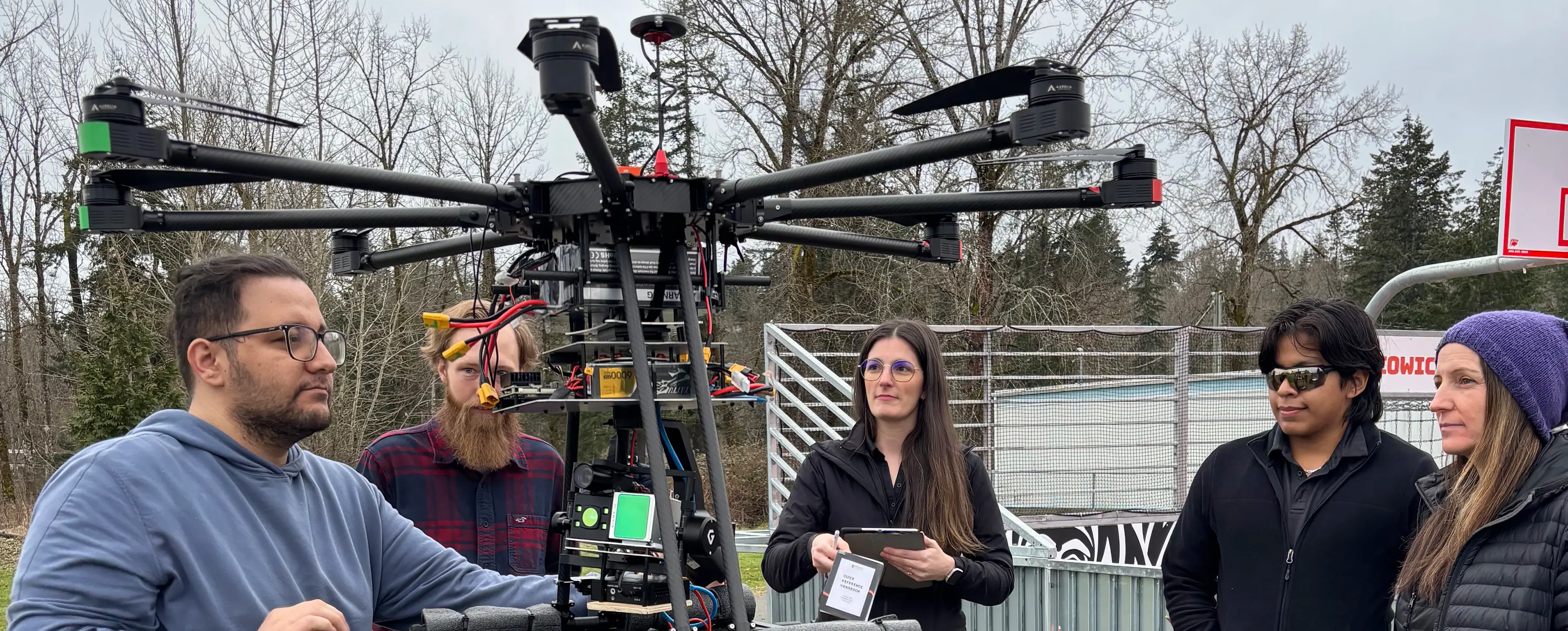
Source: UVic News
Read more: here
Canada’s Weather Map Flips: Arctic Warmer Than Southern Ontario
In a bizarre turn of events, parts of Canada’s Arctic are experiencing milder weather than southern cities like Toronto and Ottawa. Temperatures in the Northwest Territories are climbing up to 20°C above normal, while Ontario and Quebec are stuck in an Arctic chill, with temperatures 10–15°C below average.
The culprit? A highly amplified jet stream pattern that’s drawing warm air into the Arctic and sending cold air plunging south. The result: a temperature anomaly so extreme, it’s making Canada’s weather map look broken.
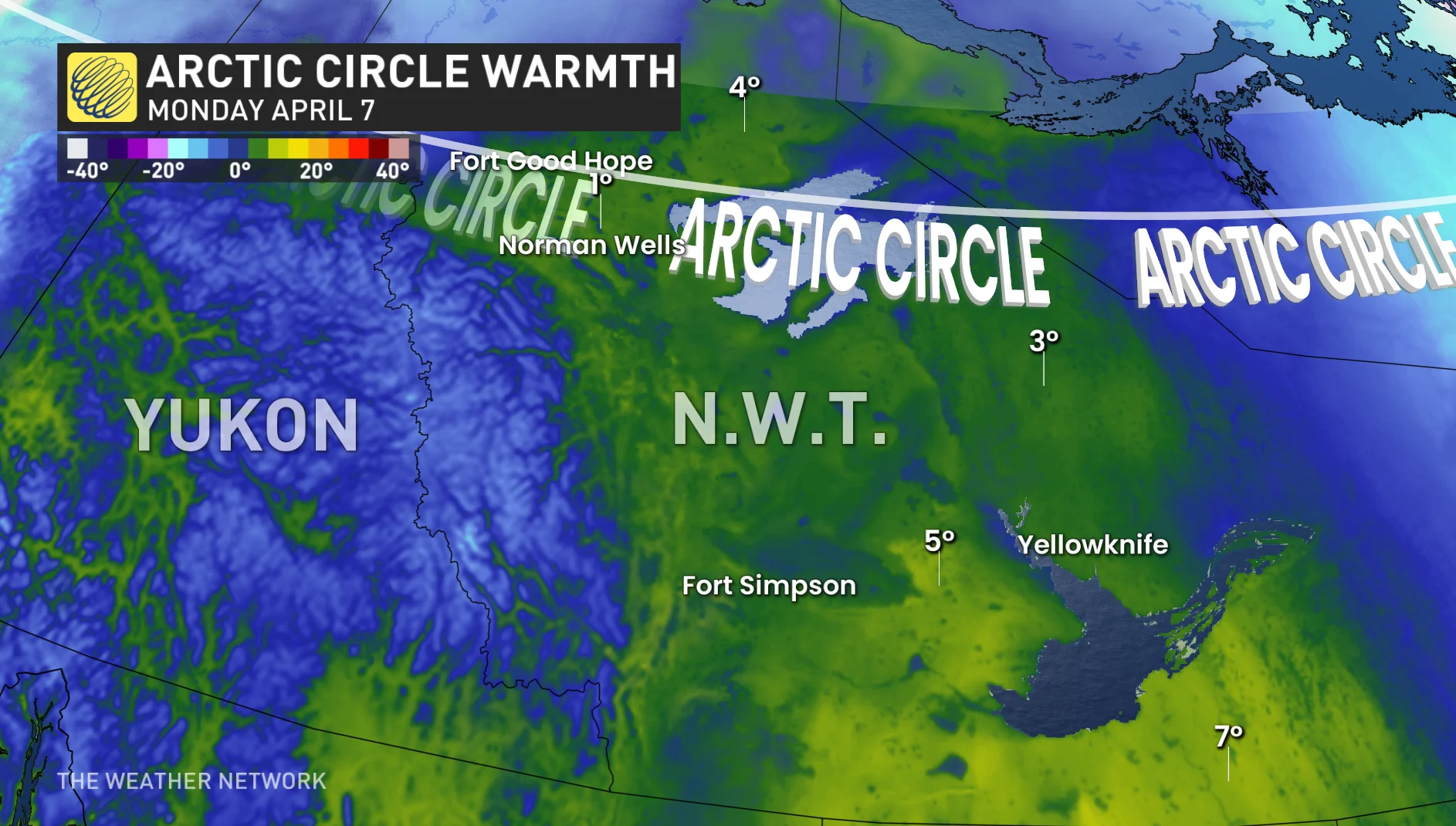
Source: The Weather Network
Read more: here
Restoring the Past: Tremaine Map of Upper Canada Now on Display
A beautifully restored 1862 Tremaine Map of Upper Canada is now on display at the University of Waterloo’s Special Collections & Archives. Originally donated in 2009, the map underwent years of meticulous conservation to preserve its rich historical detail.
Created by surveyor George Tremaine, the map offers a unique snapshot of mid-19th century life, showcasing county layouts, businesses, and even home illustrations. It’s a valuable primary source for researchers exploring settlement patterns, colonization, and urban development in Ontario.

Source: University of Waterloo Library
Read more: here
GOES-19 Satellite Now Watching Over Canada
On April 7, GOES-19 officially became GOES-East, entering service as NOAA’s newest geostationary satellite monitoring Canada, the U.S., and the Atlantic. Positioned at 75.2°W, it replaces GOES-16 and brings a major leap in weather monitoring technology.
The satellite features the Advanced Baseline Imager for detailed imagery and the Geostationary Lightning Mapper, capable of detecting both cloud-to-ground and in-cloud lightning. It also tracks sea surface temperatures, ice coverage, wind patterns, and even space weather offering a crucial edge in forecasting severe storms and monitoring hurricanes.
With an expected operational life into the 2030s, GOES-19 represents the cutting edge of Earth and space observation for the Western Hemisphere.
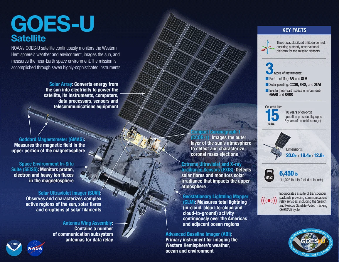
Source: The Weather Network
Read more: here
Canada and NASA Satellites Near End of Ozone Monitoring Missions
NASA’s Aura and Canada’s SCISAT satellites, key players in tracking ozone-depleting substances are nearing the end of their missions, with Aura expected to shut down by mid-2026. These satellites have provided critical insight into the “why” behind ozone changes, from halogen gases to wildfire smoke impacts.
While other satellites will still monitor the ozone layer itself, losing SCISAT and Aura means scientists will no longer have daily global scans of ozone-damaging compounds, hampering efforts to understand threats from wildfires and proposed climate interventions like aerosol injections. Without replacements, experts warn of a looming “data desert” in the stratosphere.
Proposed successors like NASA’s STRIVE and ESA’s CAIRT could restore capabilities by the early 2030s, but only if approved this year.

Source: ScienceNews
Read more: here


Be the first to comment