
- Biinaagami Giant Floor Map: A storytelling tool created by Canadian Geographic
- A colour-coded, user-friendly maps by Canada’s Travel Advice and Advisories
- A map with spatial pattern of departures in snow water equivalent in Canada
- Wyvern secures $3 million on advancing maritime monitoring and ship identification technologies
- University of Waterloo announces the transition of the Geomatics program to Geospatial Data Science.
- A new interactive gardening map for Winnipegger
Biinaagami Giant Floor Map: A storytelling tool created by Canadian Geographic
The Biinaagami Giant Floor Map, developed by Canadian Geographic, is an educational storytelling tool aimed at teaching people of all ages about the significance of water in the Great Lakes area.
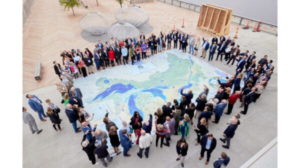
This eight–by–six-meter map is designed to inspire curiosity, responsibility, and care for the lands and waters that support nearby communities. The experience incorporates augmented reality (AR) to convey Indigenous knowledge and leads users on the journey of an Anishinaabe Water Walker — a ceremonial traveler who walks along lakes and rivers to honor water as a living, sacred relative and to raise awareness about its protection.
Read full article here
A colour-coded, user-friendly maps by Canada’s Travel Advice and Advisories
Canada’s Travel Advice and Advisories have been enhanced to include color-coded, user–friendly maps covering 230 destinations. These maps provide a visual representation of risk levels at both national and regional scales, facilitating a clearer and more immediate understanding of the security environment of each destination. This feature supports travelers in making informed decisions and maintaining safety while abroad.
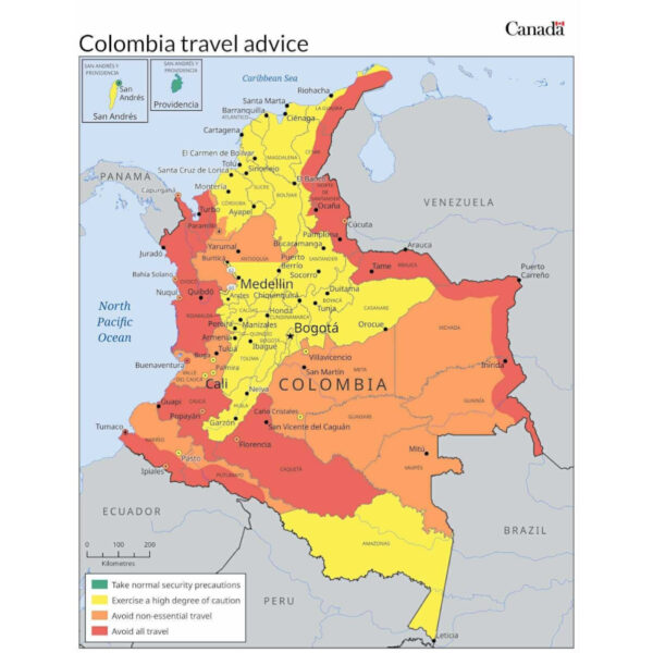
Each destination-specific page offers comprehensive information, including risk assessments, safety and security guidelines, entry and exit requirements, recommended health precautions, relevant laws and cultural considerations, as well as details on climate and potential natural disasters.
Read full article here
A map with spatial pattern of departures in snow water equivalent in Canada
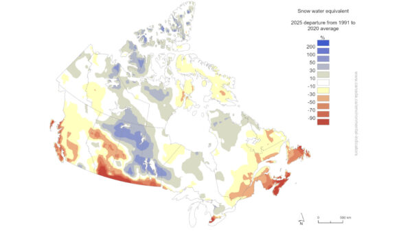
In 2025, many areas in the prairies and the Arctic had snow water equivalent levels above the average. Conversely, much of southern Canada, Baffin Island, the Pacific coast, and the Maritimes saw below-average snow water equivalent.
Read full article here
Wyvern secures $3 million on advancing maritime monitoring and ship identification technologies
Wyvern, an Earth observation company located in Edmonton, has obtained close to $3 million from the Regional Defence Investment Initiative (RDII) to improve its space-based intelligence, surveillance, and reconnaissance (ISR) technologies, with the goal of advancing maritime monitoring and ship identification systems.
This funding will also support the creation of a Defence Commercialization Centre at the University of Alberta and an Indigenous Defence Supply Chain program in partnership with Cando. The investment in Wyvern highlights ongoing federal initiatives focused on developing domestic space capabilities.
Read full article here
University of Waterloo announces the transition of the Geomatics program to Geospatial Data Science
As geospatial technologies have evolved beyond traditional surveying to include advanced GIS, remote sensing, spatial analytics, and data-driven environmental applications, this shift represents the University of Waterloo’s adaptation to technological, industrial, and educational changes that have transformed the field over the last twenty years.
At Waterloo, renaming the program from Geomatics to Geospatial Data Science more accurately represents the curriculum, where students take courses in geospatial data science, geography, environmental studies, computer science, and mathematics.
Read full article here
A new interactive gardening map for Winnipegger
A Winnipeg man created a completely free, interactive gardening map designed to foster a stronger sense of community by helping Winnipeggers share their excess crops with others in their neighborhood.
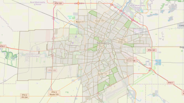
The way it works is you click on your neighborhood, enter your first name only, and then select all the vegetables you are growing. There is also a button where you can list any extra produce you have and specify whether you want to sell, give away, or trade it.
Once it has been filled out, the neighborhood turns green, indicating that there are other gardeners in the area with whom you can communicate.


Be the first to comment