- The Department of National Defence is seeking homemade rocket launching capability
- Mining takes on an important role in Canada’s nation building
- Saskatchewan Polytechnic is working alongside a Philippine NGO to support indigenous participation in environmental policy
- A partnership between the West Moberly Corporate Alliance and GeoVerra
- A new mapping resource for protecting climate-stable old growth forests in British Columbia
- A Manitoba collaboration developing a lunar satellite
The Department of National Defence is seeking homemade rocket launching capability
As part of their Innovation for Defence Excellence and Security (IDEaS) program, the Department of National Defence has released the Launch the North challenge, aiming to promote the near-term development of sovereign launch capability within Canada. Launch the North is broken into three streams, with Stream 1 focusing on the development of small-lift capability by 2028, Stream 2 focusing on the longer-term development of medium-lift capability, and Stream 3 focusing on skill and workforce development. Launch the North is open to any organization or entity incorporated and meaningfully located within Canada.
Learn more here:
Mining takes on an important role in Canada’s nation building
On November 13th, the Government of Canada released its second tranche of major nation building projects, many of which have focused on the mining industry. This focus on mining projects, along with support from the 2025 federal budget and other policy decisions, have helped to create clearer project pathways and timelines for development. Support from the federal government is also important for other critical aspect of the mining industry such as technological application, a space where the geospatial industry plays a major role. Mining will continue to be a major component of Canada’s economy going forward.
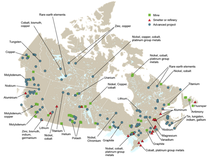
Learn more here:
Saskatchewan Polytechnic is working alongside a Philippine NGO to support indigenous participation in environmental policy
Researchers from the Saskatchewan Polytechnic Sustainability-Led Integrated Centres of Excellence (SLICE) have partnered with the Philippine NGO Daluhay and the Prince Albert Model Forest to assist indigenous communities in both countries develop the technical capacity to contribute to local environmental policy. With support from the Government of Canada’s New Frontiers in Research Fund (NFRF), participants have been developing small-scale demonstration incorporating GIS and remote sensing technologies. In the Philippines, these projects have focused on marine management and food security, while projects in Saskatchewan has focused on boreal ecosystems.
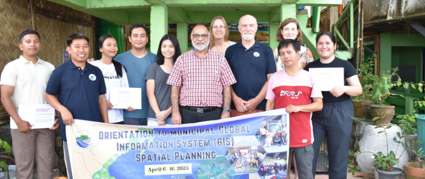
Learn more here:
A partnership between the West Moberly Corporate Alliance and GeoVerra
The West Moberly Corporate Alliance, representing the West Moberly First Nation, has partnered with the geomatics firm GeoVerra. This partnership began developing during work on the Coastal Gas Link (CGL) project. The goal of the partnership is to improve the efficiency of work within the First Nation’s traditional territory, while also supporting the community and associated projects.
Learn more here:
A new mapping resource for protecting climate-stable old growth forests in British Columbia
Researchers from the University of Alberta have developed a new tool for monitoring old-growth forests in British Columbia. This tool identifies areas of old-growth forests that fall within zones of climatic stability, where the effects of climate change are less likely to have major impacts on the ecosystem. Presently, 60% of British Columbia’s old-growth forests fall within areas of climatic stability, although less than 12% of the province’s old-growth forests fall within this zone and are also legally protected.
Learn more here:
A Manitoba collaboration developing a lunar satellite
The University of Manitoba STARLab, Magellan Aviation and the Manitoba First Nation Educational Research Centre (MFNEC) are collaborating in the development of a lunar observation satellite. The satellite CubeSat, which will incorporate traditional indigenous knowledge into its lunar navigation system and will serve as Canada’s first ever lunar spacecraft, is designed to map and collect data from the surface of the moon. CubeSat is set to launch in 2027 and will provide crucial data for future space exploration.

Learn more here:


Be the first to comment