
- Canada’s National Geomatics Awards: Vote for Geospatial Leaders.
- Is Montreal sitting on hidden rivers underneath?
- Montreal-made Quantum sensors could be a next breakthrough
- Mapping Calgary’s August hailstorm
- Mapping snowpack depth in Canadian Rockies using Airborne Lidar.
Canada’s National Geomatics Awards: Vote for Geospatial Leaders
An award is an acknowledgment of excellence! Canada’s National Geomatics Expo Awards provide a wonderful chance to spotlight both individuals and organizations making a difference in the geomatics sector. Whether it’s innovative technology or exceptional leadership, these awards celebrate achievements that propel the industry forward.
This year’s nominations were chosen by the public, and it is now your opportunity to vote for them. You can vote in all or just the categories that interest you. The winners will be announce at Canada’s National Geomatics Expo October 30th in Calgary. To know the details about categories of awards and more, visit here.
Is Montreal sitting on a hidden river underneath?
All of Canada’s largest cities were developed on top of river networks, diverting and limiting tributaries to often overwhelmed sewer systems.
Something similar occurred in the city of Montreal. At the time of flooding this year, some of the residents of Montreal who were stranded on Highway 40 got their hands on old maps of the city while passing their time in the car. Surprisingly, they discovered that they were actually sitting on a river that flows right beneath the highway.
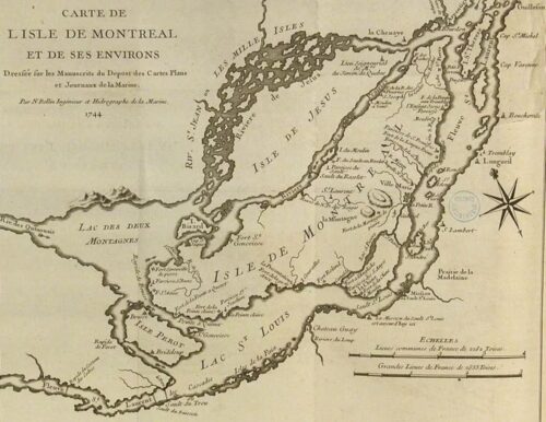
In areas where streams have been buried, the ground is frequently already saturated, so it cannot absorb more water, and the water cannot make its way to a stream, causing a problem.”
The river that once ran through Highway 40 still exists. The eight-kilometer tributary known as Rivière à l’Orme is the last, mostly undamaged river on the island. Go through the news article here.
Montreal-made Quantum sensors could be a next breakthrough
Quantum-level errors in synthetic diamonds may be applied for developing the next generation of magnetic field maps. SBQuantum, a Sherbrook (QC)-based company, wants its sensors to be used to develop the next generation of magnetic field maps, which are vital for mobile phone navigation applications as well as helping space agencies switch to tiny satellites called “cubesats.”
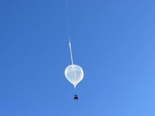
The sensor was sent into the stratosphere in a high-altitude balloon as part of the company’s partnership with the Canadian Space Agency. In the test conducted in May, the sensor was exposed to radiation and low pressure, as well as temperatures as low as -60 C. It was also tested for resilience to the shock of a rocket launch and a rough landing. All of these factors were tested for approximately 12 hours at an altitude of 40 km, which is nearly four times higher than the cruising altitude of a long-haul commercial plane.
The company’s ongoing research and development is additionally supported by the contract with the European Space Agency (ESA). Read more here.
Google like streetview from sky: B.C. drone company’s largest drone imaging network
A Vancouver based company (Spexi Geospatial Inc.) has been building visual aerial database after collecting drone-based imagery. Over the past 18 months, it has gathered a stable of amateur drone enthusiasts throughout British Columbia to record aerial photographs resulting into a complete crowd-source imaging network. 131 B.C. municipalities are now covered by a visual aerial database that the business calls “Google Streetview of the Sky.”
On the other hand, Spexi’s overhead and panoramic views were able to capture images with a resolution of as tiny as 2.8 centimeters.
That’s more than thirty times higher quality than the typical commercial satellite and more than three times better than what airplane cameras typically catch. Read more here
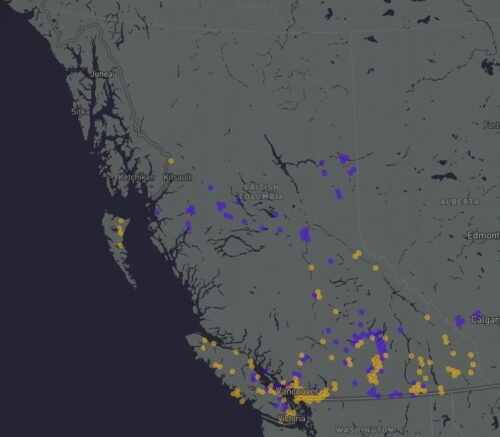
Mapping Calgary’s August hailstorm
Hailstorm survey data helped create this interactive map of Calgary showing areas affected by hailstorm in the peak summer month of August. Northern Hail Project (NHP) survey team collected data on hail and areas damaged by the storm. Here is the snapshot of the map.
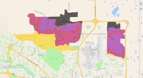
Hail damage contours range from minor to severe. The city’s extreme north appears to have been the worst affected area. Know more on this here.
Mapping snowpack depth in Canadian Rockies using Airborne Lidar
Lidar data, when combined with topographical information, land cover data, and satellite photography, enables continuous snow depth imputations. This is critical for calculating sub-basin-scale snow water equivalent (SWE), which informs water availability and leads management options, especially in the rising drought scenario in Alberta this year. This government-sponsored initiative, led by Dr. Chris Hopkinson of the University of Lethbridge, hopes to substantially advance our understanding and management of water resources in Alberta’s mountainous regions. Read more here

Be the first to comment