
- Tintina Fault Line on Canadian Border Could Cause Major Earthquake
- Shifting Growing Zones: Citrus Trees Have a Chance In Canada
- Manitoba’s Toxic Wildfire Smoke Needs More Research
- Pomerleau Wins Esri Special Achievement Award
- PFAS in Great Lakes and St. Lawrence River: A Follow-up Story
- Canada And Australia Agree to Collaborate on Arctic Over-The-Horizon Radar
Tintina Fault Line on Canadian Border Could Cause Major Earthquake
About 600 miles from northeastern British Columbia into Alaska is the Tintina fault, which was active about 40 million years ago.
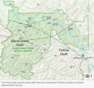
Geological formations that are 2.6 million years old and 132,000 years old are laterally shifted across the fault, as indicated by new topographic data obtained from satellites, airplanes, and drones. This segment of the fault is approximately 80 miles in length.
Using surficial mapping, geochronological constraints, and recent ArcticDEM and drone lidar topographic data this is the first concrete proof of major surface-rupturing earthquakes on the Tintina fault from 2.6 Ma onward.
Read full article here
Shifting Growing Zones: Citrus Trees Have a Chance In Canada
Plant Hardiness Zones map — the first update since 2014 has been released. Canada is divided into ten zones on the map, with subzones designated “A” and “B.” The zones are numbered zero through nine. The more moderate the weather and growing circumstances, the higher the zone number.

In the most recent version, the relatively rare and hardiest 9A zone has grown from a blip on the map to spanning parts of Vancouver Island and the southern reaches of British Columbia’s lower mainland. Those places may be ideal for certain palms and even cold-hardy citrus, which is unusual in Canada. Warming temperatures have caused the zone to expand in around 80% of the country.
Read full article: here
Manitoba’s Toxic Wildfire Smoke Needs More Research
Wildfire smoke in Manitoba is claimed to be re-releasing toxic chemicals stored in the soil for around a millennium. The province is one-third covered in peatlands, which are vital for storing carbon and toxic metals. Canada is a peatland-rich nation. To avoid poor health effects in the nearby communities, thorough research on wildfire smoke pollutants is necessary.
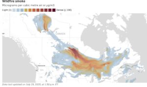
Wildfires are more likely to occur in drier landscapes brought on by warming temperatures. The pollution density of the smoke from wildfires in some regions of Canada is depicted on this map.
Read full article: here
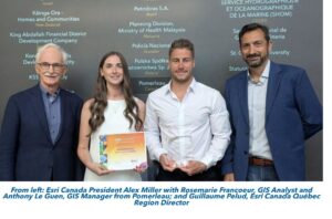
Pomerleau Wins Esri Special Achievement Award
Pomerleau, one of Canada’s leading construction companies, has been honoured with the renowned Esri Special Achievement in GIS (SAG) Award. Pomerleau was picked from thousands of Esri customer organizations worldwide for their innovative use of geographic information system (GIS) technology, integrated with building information modelling (BIM) and Internet of Things (IoT) technologies, for the “Ciment Québec” project, which was completed 33% faster than expected.
The new centre’s digital BIM models were combined with location-based data using ESRI’s ArcGIS technology, resulting in a dynamic digital twin of the construction process.
Read full article here
PFAS in Great Lakes and St. Lawrence River: A Follow-Up Story
Forever chemicals are contaminating the freshwater systems in Canada, including the Great Lakes and St. Lawrence River. The Great Lakes supply drinking water to one-fifth of the Canadian population. Their levels have been closely monitored for a few years now and have been rising higher than the national average.
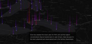
Environment and Climate Change Canada sampled for PFAS concentrations between 2016 and 2024. The PFAS readings are derived from an investigation of the 17 most prevalent PFAS identified in the Great Lakes and St. Lawrence River.
Also, Elevated levels have been found in some creeks and rivers that flow into Lake Ontario. They remained at 10 ng/l or higher as far east as the city of Lévis, Quebec.
Read full article here
Canada and Australia Agree to Collaborate on Arctic Over-the-Horizon Radar
Last month, Canada and Australia signed a technical partnership agreement to expand their work on advanced Arctic over-the-horizon radar (A-OTHR) technology.
This agreement would enable Australian and Canadian enterprises to collaborate to “build expertise and capacity in Canada.” The partnership aims to create more job opportunities for Canadians, as well as participants in the sovereign defence industry, while also advancing radar technology.
The Arctic Over-the-Horizon Radar (A-OTHR) reflects radio signals to detect targets up to 3000 kilometres distant. The transmit beam leaves Earth, reflects off the ionosphere, and reaches a target area within the ‘Illumination region.’
Read full article here


Be the first to comment