
- PhotoSat Launches Regional Hyperspectral Targeting Tool for Mineral Exploration
- NordSpace’s Atlantic Spaceport Clears Environmental Review, Moves Toward Canada’s First Orbital Launch Site
- 3D Mapping Pilot Shows How Indoor GIS Could Improve Safety in Edmonton’s LRT System
- Outdated Flood Maps Spark National Debate Over Risk, Property Values, and Public Safety
- CLIMAtlantic Expands Climate Adaptation Training Program Across Atlantic Canada
- Canada Updates National Satellite-Based Forest Monitoring System
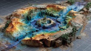
PhotoSat Launches Regional Hyperspectral Targeting Tool for Mineral Exploration
Canadian geospatial company PhotoSat has introduced a new Regional Hyperspectral Exploration Targeting (R-HET) product that uses next-generation hyperspectral satellite data and deep-learning algorithms to improve mineral exploration from space. The solution enables exploration teams to detect more than twice the number of alteration minerals compared to traditional multispectral approaches, identify subtle mineralogical variations, and map mineral abundances at a regional scale. A recent case study over the Maricunga Volcanic Belt demonstrated the tool’s ability to reveal mineral assemblages that were previously difficult to detect, helping reduce early-stage exploration costs and accelerate discovery timelines.
Read more here.
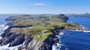
NordSpace’s Atlantic Spaceport Clears Environmental Review, Moves Toward Canada’s First Orbital Launch Site
NordSpace has received landmark environmental approval for its Atlantic Spaceport Complex in Newfoundland and Labrador, allowing construction and operational preparations to move forward ahead of Canada’s first purpose-built sovereign orbital launch attempts. Located on Newfoundland’s southern coast, the spaceport’s geographic position enables access to a wide range of orbital inclinations, including polar and sun-synchronous orbits, making it strategically important for Earth observation, defence, and space-based geospatial intelligence missions. The approval follows more than two years of environmental, safety, aviation, marine, and community assessments and positions Atlantic Canada as a key node in Canada’s growing space and geospatial infrastructure ecosystem.
Read more here.
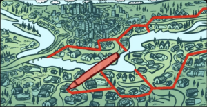
3D Mapping Pilot Shows How Indoor GIS Could Improve Safety in Edmonton’s LRT System
The Edmonton Police Service, in partnership with Esri Canada, has piloted a 3D mapping and indoor positioning system to improve safety in underground LRT stations where GPS signals fail. The Edmonton Transit Enhanced Community Safety System (ETECS) combines a 3D digital twin of stations with indoor location tracking using Wi-Fi and mobile devices, allowing officers to be monitored in real time below ground. By providing a three-dimensional view of underground spaces, the system supports officer safety, emergency response planning, and the identification of activity hotspots, offering a new geospatial approach to public safety in complex transit environments.
Read more here.

Outdated Flood Maps Spark National Debate Over Risk, Property Values, and Public Safety
As Canada works to modernize decades-old flood maps, outdated and incomplete geospatial data is emerging as a major risk to communities facing more frequent flooding. In Quebec and across the country, efforts to update flood-risk maps using climate projections and hydrological modelling have triggered public pushback, driven largely by fears over insurance costs and declining property values. Experts warn that without accurate, publicly accessible flood maps, governments, homeowners, insurers, and emergency planners are left unprepared for the country’s most common climate hazard, reinforcing the need for transparent, science-based geospatial mapping to guide long-term flood mitigation and land-use decisions.
Read more here.
CLIMAtlantic Expands Climate Adaptation Training Program Across Atlantic Canada
CLIMAtlantic has received federal funding from Natural Resources Canada to expand its Climate Adaptation and Resilience Training (CART) Program, which focuses on building climate readiness across Atlantic Canada. The program supports professionals from non-profits and other sectors with place-based risk assessments, guidance on interpreting climate data, and networking opportunities tailored to regional climate challenges. With 190 participants trained so far and an additional 200 expected by 2026, the initiative aims to strengthen climate adaptation capacity in a region increasingly exposed to floods, hurricanes, and other extreme weather events.
Read more here.
Canada Updates National Satellite-Based Forest Monitoring System
The Canadian Forest Service has released an updated overview of the National Terrestrial Ecosystem Monitoring System (NTEMS), a satellite-driven framework for monitoring Canada’s forested ecosystems at a national scale. Built primarily on Landsat time series data and supported by open-access analysis-ready datasets and high-performance computing, NTEMS provides detailed land cover, forest structure, biomass, and post-disturbance recovery information. The system is underpinned by peer-reviewed science and supports open data product development, with annual updates documenting the growing body of research behind Canada’s long-term forest monitoring efforts.
Read more here.


Be the first to comment