
Every week, GoGeomatics contributors and editors review geospatial stories from around the world and select developments we think deserve the attention of the Canadian geospatial community.
This week, we discussed several stories which shared common themes centered around geospatial technology in Canada. The stories all discussed the growing role of Canadian geospatial technologies in solving real world challenges. From the use of autonomous drones being deployed to detect and manage wildfires in Alberta to sonar and underwater imaging being used to capture 3D images of the Terra Nova Shipwreck. These stories highlight the growing potential of geospatial technologies.

One of the most compelling stories highlighting the advancement of Canadian geospatial technology was the story of Earthdaily’s EDC-08.
On July 9, 2026 – EarthDaily announced the successful contact with their EDC-08 spacecraft two days after it was launched aboard a SpaceX rocket on July 7, 2026. As the name suggests, this is the eighth spacecraft that EarthDaily has launched this allows for EarthDaily to begin commercial operations.
The spacecraft that EarthDaily have in their constellation are all designed the same. They all carry 16 imagers which collect data across 22 spectral bands, this allows them to consistently compare measurements across different regions, seasons and times.
Wile EarthDaily continues to work on their calibration and validation, the images that they have been releasing have been proving that multiple satellites are contributing to a system built for reliable broad-area monitoring and analysis. These analyses are constantly being improved by AI and machine learning.
This story highlights two very important things for Canada and geospatial technology. Firstly, it strengthens the Canadian space sector and the presence as well as relevance of Canada in the international space scene. Lastly, the approach that is being taken by EarthDaily allows Earth Observation to move beyond traditional methods by utilizing AI and machine learning. This technology can allow for us to better monitor climate resilience, natural resources, and infrastructure.
Source Link: https://earthdaily.com/blog/earthdaily-constellation-entering-commercial-operations-with-successful-launch-iii
UVic satellite to probe climate, open-source radio

The University of Victoria (UVic) has had its students and researchers design and build a satellite the size of a show box that will be used for two thigs simultaneously. First, to probe the ionosphere so we can have clues about climate change. Second, flying a radio communications system which will be fully open-source.
The name of this satellite is called MARMOsat which is the second CubeSat for UVics’ Centre for Aerospace Research (CfAR) to be launched into space aboard a SpaceX Falcon 9.
The data that the MARMOsat collects is in reference to the structure and composition of ionosphere. The purpose of this specific data collection is for researchers to analyze how the ionosphere is shifting as a result of human-induced climate change. Its second job as an open-source radio is designed to provide amateur radio operators across the globe to communicate with satellites.
Although this is UVics second satellite to reach space the university still possesses bold plans for the future. A third mission “Polar Link” is already set for 2027. This mission will focus on the Arctic and monitor Arctic communications, testing high-data-rate, and low latency technologies. The purpose of this mission is to bridge the current gap in connectivity in the Canadian North.
Source Link: https://news.uvic.ca/2026/uvic-satellite-to-probe-climate-open-source-radio/
Marine simulation centre of excellence to open in Canada

The Marine Innovation Simulation Centre of Excellence (MISE) is a CA$76.5 million investment by the British Columbia Institute of Technology (BCIT). The initiative which is being taken in partnership with Kongsberg and Kongsberg Maritime is designed to improve maritime skill development and aid Canada’s Defence Industrial Strategy by building on some of their key objectives.
The MISE will provide a synthetic environment, development tools, and application programming interfaces (API) which will support research with Canadian stakeholders.
The simulation will serve as a place to prepare/plan for many aspects of maritime life. This can include maritime safety, autonomy, critical infrastructure, port development, and low-emission operations. This creates a safe environment for maritime workers to train and test technologies without the potential risks they may face while out at sea.
The BCIT also plans to extend learning beyond the campus by being provided licenses that will allow for cloud-based simulation systems. This can allow for additional practice hours and remote training models for students, it also allows access to maritime education for Indigenous communities.
Source Link: https://smartmaritimenetwork.com/2026/07/09/marine-simulation-centre-of-excellence-to-open-in-canada/
TEKEVER, Phoenix Heli-Flight bring autonomous wildfire detection to Alberta
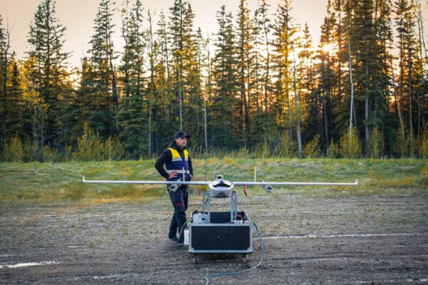
Phoenix Heli-Flight, a Helicopter charter in Fort McMurray, will operate TEKEVER’s autonomous drone (the AR3 UAS) to detect and manage wildfires in Alberta.
The aircraft will be equipped with specialist sensor technology and TEKEVER’s Nova Maps software platform. This will allow for information to be gathered and processed remotely and delivered to wildfire agencies.
Due to Alberta’s remote terrain and it’s susceptibility to wildfires, having consistent aerial monitoring can be challenging. The introduction of the AR3 UAS marks a significant step in wildfire management due to its ability to provide consistent monitoring. This essentially fills the space between satellites, ground observation, and traditional aviation.
Although the AR3 UAS is considered an autonomous drone it does not eliminate the need for human labour. Personnel are still responsible for flight path planning, launch and recovery, and coordinating airspace.
Source Link: https://skiesmag.com/news/tekever-phoenix-heli-flight-bring-autonomous-wildfire-detection-to-alberta/?amp
Expedition unveils first detailed images of Robert Falcon Scott’s final ship – Terra Nova

Robert Falcon Scott a British Naval Officer who led two expeditions to Antarctica had his ship (the Terra Nova) imaged with great detail with the use of Canadian underwater technology.
The Royal Canadian Geographical Society (RCGS) and the Woods Hole Oceanographic Institution (WHOI) surveyed the ship 10 nautical miles off the southern coast of Greenland and with the use of the RCGS’ ‘Voyis’ 3D photogrammetry systems and the WHOI’s ‘Falcon’ the pair was able to create the first detailed image of the Terra Nova.
The RCGS and the WHOI have also succeeded in the creation of a digital twin for the Terra Nova for public engagement, preservation, and further scientific research. AI-powered wearable technology is also being deployed which provides the members of the expedition a hands-free way to capture and share their work.
With the use and utilization of Canada’s ‘Voyis’ 3D photogrammetry systems being the first to capture detailed images of the shipwreck, this marks a huge stepping stepping stone in Canadian geospatial technology.
Source Link: https://www.heritagedaily.com/2026/07/expedition-unveils-first-detailed-images-of-robert-falcon-scotts-final-ship-terra-nova/158606

Be the first to comment