
- Canadian Federal Election results: Live Map Showing Shifts Since 2021
- Tiny Grids, Big Insights: Mapping Canada’s Urban and Rural Economies
- Ditch Starlink: Indigenous Innovation is Canada’s Top Solution for Rural Internet
- Canada Ceased Sending Satellite Imagery to Ukraine Two Years Ago
- The Drone Revolution: Inside Spexi’s rise to the World’s largest Imaging Network
- Drones, Sensors and Smart Trucks to Test Mobility on Blue Water Span
- David Thompson: The stargazer who drew Canada
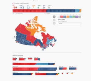
Canadian Federal Election results: Live Map Showing Shifts Since 2021
In a surprising comeback, Mark Carney’s Liberals won the 2025 federal election. They picked up seats in Quebec, Manitoba and Ontario. The Conservatives also improved in Alberta and parts of Ontario. The New Democrats fell to seven seats and the Bloc dropped to 22. Canada’s ridings grew from 338 to 343 after boundary changes. Votes from 2021 were adjusted for the new map. Early returns from Atlantic Canada showed a Tory surge. Still, Liberals prevailed in key areas like Nova Scotia and British Columbia. The live map shows each riding’s result and the vote shifts since 2021. See full article here.
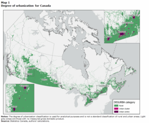
Tiny Grids, Big Insights: Mapping Canada’s Urban and Rural Economies
Statistics Canada mapped GDP and GDI data across detailed 1-kilometer grid squares. Rural areas, home to 22.8% of Canadians, provide 23.1% of the nation’s GDP. Most rural output lies near markets in southern Ontario, central Alberta, and coastal British Columbia; remote regions produce less. Urban centers use just 1.7% of land but produce over 60% of GDP and earn 65% of national income. The analysis breaks rural squares into market-accessible and distant; 60.6% of rural output comes from the former, and distant areas account for just 9.1% of GDP. The grid method maps economic activity without using national administrative boundaries. Read the complete article and analysis here.
Ditch Starlink: Indigenous innovation is Canada’s top solution for rural internet
In summer 2023, wildfire evacuees near Yellowknife used a Wi-Fi network built by KatloTech founder Lyle Fabian to stay connected. His Indigenous-led solution shows how northern communities can build hybrid networks. Meanwhile, Starlink now serves 400,000 Canadians but repatriates profits to the U.S. and risks local markets. Indigenous initiatives like K-Net and Eeyou Communications run fiber and satellite links across First Nations, hiring local technicians and keeping revenues in the community. New CRTC funding rules favor these smaller providers. Canada’s past in bush radios and domestic satellites proves we can reclaim our digital sovereignty with local networks. Read on in the article here.
Canada Ceased Sending Satellite Imagery to Ukraine Two Years Ago
In early 2023, Canada quietly stopped providing Ukraine with radar images from Radarsat-2, ending a program with Brampton-based MDA that began in March 2022. The data showed where Ukrainian forces and Russian troops moved at night and through clouds. When the one-year government license expired, it wasn’t renewed—leaving Ukraine without this imagery just as U.S. support paused. The move surprised security experts, who question why the deal wasn’t extended. Now Ukraine must turn to other satellite providers for urgent battlefield intel. The lapse points to gaps in Canada’s use of private-sector earth-observation data to support allies. Check out the details here.
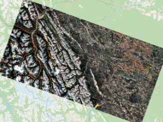
The Drone Revolution: Inside Spexi’s Rise to the World’s largest Imaging Network
In his journey from tile setter to Spexi CEO, Alec Wilson blended GIS and aviation. He studied geography and then earned a commercial helicopter license. A near collision with a drone led him to co-found Coastal Drone, training pilots and shaping regulations. In 2021, he joined Spexi, building a network of freelance microdrone pilots. Spexi now covers over three million acres with ultra-high-resolution imagery. Cities use the data for planning and wildfire response. Spexi raised $23.5 million in Series A funding. He aims to fuel future AI models with standardized imagery. Wilson credits his team for making it all possible. Read more details here.
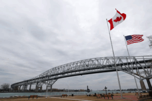
Drones, Sensors and Smart Trucks to Test Mobility on Blue Water Span
Over the summer, the Blue Water Bridge between Port Huron, Michigan, and Sarnia, Ontario, will host trials of mobility and emissions technologies. A group of ten start-ups will test sensors, drones, CCTV cameras, and truck formations under real-world conditions. The Ontario Vehicle Innovation Network and FedDev Ontario fund the program. Participating companies will collect data on traffic flow, vehicle behaviour, emissions, and bridge health. Bridge operators assure that normal traffic and border operations will continue without disruption. Local residents and commuters have been notified of greater on-site activity. These pilot projects will run through autumn to refine emerging transport solutions. Read details here.
David Thompson: The Stargazer Who Drew Canada
David Thompson, born in Wales in 1770, overcame poverty and harsh schooling to apprentice as a fur trader and master celestial surveying. Despite losing sight in one eye and walking with a limp after injuries, he mapped the Columbia River from its source to the Pacific and traced 2,000 miles of the Canada–US border with one-mile accuracy. Thompson lived among First Nations, married a Cree woman named Charlotte, and helped lay out streets in emerging Canadian towns. He died in Montreal in 1857, leaving behind maps that still set modern boundaries, a 57-year marriage record, and a legacy of national exploration. Read further here.


Be the first to comment