Mapping Canada’s PFAS Hotspots: A CBC Interactive Map
Dokis First Nation: Drones and Land Management
McGill Study Reveals Increased Earthquake Vulnerability for Marginalized Communities
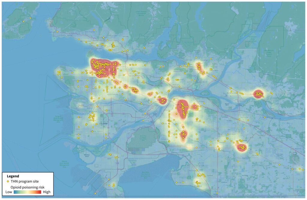
Optimizing Naloxone Kit Placement in Vancouver
Canada’s HAWC Mission Opens New Frontiers in Atmospheric Mapping
NAIT Cuts Geospatial Program Amid Budget Crunch
Mapping Canada’s PFAS Hotspots: A CBC Interactive Map
PFAS or per- and polyfluoroalkyl substances, also known as ‘forever chemicals’, are increasingly being talked about as hazardous to human health. CBC has worked to create a visually appealing interactive story that highlights some of the highest risk PFAS sites across the country. Taking data from the federal government, we can explore and see the hazardous federal sites by hazard type, size, and proximity to wells and population. Reminiscent of John Snow’s cholera maps of London, this is a very informative and interactive story map that you will definitely want to check out and follow along as it continues to be updated with clean-up efforts.
Dokis First Nation is located on the remote southern shores of Lake Nippissing, and oftentimes reaching the community can mean dealing with some pretty treacherous road conditions. That has historically lead to difficulty working with contractors and obtaining important spatial data to inform the communities decisions. However, that is quickly changing thanks to advances in geospatial technology being adopted by Dokis First Nation Lands Administrator Randy Restoule. Now employing a Matrice 350 RTK Drone, the community has flown their own imagery and Lidar, and no longer needing to rely on outside sources to gather this information has accelerated development opportunities. Next up, ground penetrating radar.
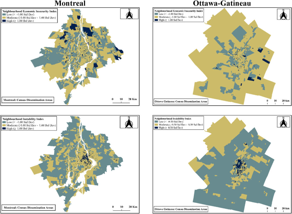
McGill Study Reveals Increased Earthquake Vulnerability for Marginalized Communities
A new study from McGill University highlights social vulnerability analysis to expose how earthquake risks disproportionately impact marginalized communities in Montreal and Ottawa-Gatineau. Using 2021 Census data integrated with Canada’s Probabilistic Seismic Risk Model, researchers employed advanced GIS techniques to identify dangerous intersections between seismic hazards and social inequity. The spatial analysis revealed that recent immigrants, seniors, visible minorities, and single-parent families cluster in neighborhoods with vulnerable older housing stock.
A new study on opioid-poisoning incidents recorded by BC Emergency Health Services between December 2014 and August 2020 in Metro Vancouver demonstrates how geospatial analytics can optimize life-saving naloxone kit placement across the city. Researchers employed modeling of 14,089 opioid poisoning incidents using network analysis to determine 3-minute walking coverage areas and optimization algorithms to identify strategic placement locations. The study compared three spatial strategies: existing take-home program locations (35.4% coverage), blanket placement at chain businesses and pharmacies (0.7-22.4% coverage), and optimization-based transit stop placement (20.6-53.3% coverage). Will this have an impact that can save lives, and will other cities carry out similar studies? There certainly seems to be the case for it.
Canada’s HAWC Mission Opens New Frontiers in Atmospheric Mapping
The Canadian Space Agency has put out a call for work on its High-altitude Aerosols, Water vapour and Clouds (HAWC) mission, also called HAWCsat. It is a Canadian led mission in which Canada will build the satellite and provide two instruments, the Aerosol Limb Imager (ALI) and Spatial Heterodyne Observations of Water (SHOW). The CSA has allocated a maximum of $870,000 in funding in the form of grants for Canadian universities and post-secondary institutions. The grants will be distributed across 3 streams including conducting ground-based and/or airborne data collection, conducting model development and/or data analysis, or advancing applications enabled by HAWC/AOS for a healthy and climate-resilient Canada.
The Northern Alberta Institute of Technology’s decision to pause 18 programs, including the surveying and geospatial engineering technology diploma, adding to the unfortunate trend of cuts seen among post-secondary programs in Canada. The program suspension is attributed to declining international enrolment and federal study permit caps, but also highlights the vulnerability of specialized technical education in Canada’s post-secondary system.
How are the GoGeomatics Briefing created?
All across Canada, our volunteer editors and group writers gather virtually, on a weekly basis, to discuss and share the newest geospatial news together. Each Writer prepares a few interesting articles that they have researched about, and they share why the reason behind selecting their piece with the other writers. Each researched article is selected based on the relevancy, credibility and interest to the geospatial community. After the team shares all their researched articles, all members vote on the most relevant pieces to write a briefing about.
Our volunteers’ dedication is very valuable to our community. Their efforts embody the spirit of what it means to really be the change you wish to see in the community.
Canada Maps and Poster Gallery Returns to GeoIgnite 2026 The Canada Maps and Poster Gallery returns to GeoIgnite 2026, taking place May 11 to 13 at the Ottawa Conference and Event Centre, showcasing the breadth […]
As 2026 begins, the GoGeomatics volunteer and editorial team took time to reflect on the year just past and identify the Canadian geospatial stories and though leadership that mattered most in 2025. Together, these selections […]
19 Countries in the Americas Trained in Geospatial AI for Faster Emergency Analysis Russia Restricts Nighttime Mobile Networks to Disrupt Drone Operations Guided by Geolocation Signals Geopost Transforms Delivery Fleet into a High-Frequency Mapping Asset […]


Be the first to comment