
- Statistics Canada Releases Health Data
- Accelerating Utility Intelligence With 10x Faster Data Delivery
- Here’s a Halloween Map of the Biggest Scary Houses to Visit in London
- Pixxel and Pacific Geomatics Partner to Bring Hyperspectral Satellite Data to Canada
- GHGSat Says Climate Action Work Hasn’t Slowed
- NRCan Makes More High-Resolution Lidar and Elevation Data Available
Statistics Canada Releases Health Data
Statistics Canada has released some extensive geographical related health data. Although maps have yet to be made for these data groups, data subjects such as ‘Canadian Social Environment Typology’, ‘Index of Remoteness’, ‘Canadian Index of Multiple Deprivation (CIMD)’, ‘Health Regions’, and ‘Health Regions Peer Groups’ are all publicly available. This data can be used to a great advantage to help public health learn more about how remote regions could use help based on their circumstances. Read more here.

Accelerating Utility Intelligence With 10x Faster Data Delivery
West Coast Utility developed a new method to drastically reduce the time and training effort to map utility pole assets. A pod was developed that utilized high-performance lidar sensors for long-range detection in mountainous terrain and dense vegetation. Now that all the functions of the Lidar mechanics are all integrated, the process is much faster for onboarding and extremely more efficient for localizing data. Read more here.

Here’s a Halloween Map of the Biggest Scary Houses to Visit in London
On a more festive note, the residents of London, Ontario have teamed up for Halloween to build a haunted-house charity event. When visiting these areas, community members are encouraged to donate non-perishable items. An interactive map for all the spooky locations has been made by the community to help spread the word. This showcases how geospatial tech can be used to bring communities together for fun and charity. Read more here.

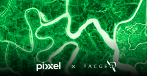
Pixxel and Pacific Geomatics Partner to Bring Hyperspectral Satellite Data to Canada
Pixxel, a leader in hyperspectral Earth-imaging satellite technology, has partnered with Pacific Geomatics Limited (PacGeo) to bring its advanced hyperspectral satellite data to Canada. The hyperspectral constellation has a 5-meter resolution across up to 135+ spectral bands, going well beyond the traditional multispectral systems. Read more here.
GHGSat Says Climate Action Work Hasn’t Slowed
GHGSat is seeing growing demands in their methane emission satellite monitoring services in the United States despite the recent political shifts. Additionally, the recent partnership with ExxonMobil and a $47 million funding boost also shows how in-demand GHGSat’s services actually are. Not only is this service in an effort for environmental conservation, companies stand to gain the benefit of reduced revenue loss from leaking resources. Read more about GHGSat and their partnership here.

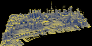
NRCan Makes More High-Resolution Lidar and Elevation Data Available
Natural Resources Canada has updated their high-resolution lidar imagery of the country. 709,000 km² of new, lidar-derived elevation data now covering 244 of Canada’s 250 largest cities, and over 95 percent of the population has been updated. The database includes HRDEM & HRDEM Mosaics, Northern HRDEM data, Automatically Extracted Buildings, and Lidar Point Clouds which can be used as a powerful tool for urban planning, infrastructure development, environmental monitoring, and more. Read more here and here.


Be the first to comment