
- NordSpace Planning Another Attempt at Rocket Launch in St. Lawrence by Mid-Month
- Peatlands as Canada’s Carbon Keepers
- Information into Action: Mapping Complex Data
- GHGSat Partners with ExxonMobil for ‘Significant Investment’ in Onshore Methane Monitoring
- Volatus Aerospace Gets Nod to Launch Scalable Automated Drone Services
- SimActive Enables 3D Calculations from Drone Imagery at Mining Sites
NordSpace Planning Another Attempt at Rocket Launch in St. Lawrence by Mid-Month
NordSpace, a Canadian space technology company based in Markham, Ontario, is making another attempt at launching one of its rockets. The delay was caused prematurely by the safety system kicking back, which was a positive note quoted by CEO Rahul Goel. The next attempt will take place between September 20, 2025, and September 27, 2025. Supporting Canadian space technology companies is great for the Canadian geospatial community to help grow platforms for information technology.
Visit NordSpace’s website directly for more details here and read more on the missed launch day here.

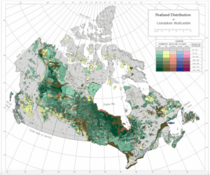
Peatlands as Canada’s Carbon Keepers
Canada has a lot of carbon sinks across the country, and peatlands are no exception, covering “more than 12% of Canada’s land area and containing an estimated ~25% of the world’s peatland carbon reservoir”. These water-logged ecosystems allow for natural peat to form, which acts as a carbon sink by not fully decomposing plant matter. There’s a concern over the decline of peatlands caused by draining the lands for agriculture, forestry, mining, and oil and gas extraction. These activities release the stored carbon and disrupt the processes that store carbon. A research survey by April Dalton through the University of Waterloo in Ontario used peat-depth measurements to “identify carbon ‘hot spots’ for prioritizing peatlands for conservation”. The results were digitized and mapped and are showcased in the article linked to this synopsis.
Read more about April Dalton’s research here.
Information into Action: Mapping Complex Data
Selkirk College, located in Castlegar, British Columbia, partners with Innovates and Living Lakes Canada, a Canadian NGO that focuses on water stewardship, to deliver summer mapping programs that help strengthen public education and support community-based conservation efforts. Hannah Murphy shares her experience with the co-op education program and how she got a strong reaction to not only the mapping projects but the community involvement.
Read more about her experience here.
GHGSat Partners with ExxonMobil for ‘Significant Investment’ in Onshore Methane Monitoring
GHGSat has shared its partnership with ExxonMobil Corp. and their goals for emission monitoring and help with efficiencies to reduce emissions. This partnership is aided by GHGsat’s continuous effort to build a fleet of satellites in hopes of having “21 satellites on-orbit by 2026”. GHGsats reputation and the growing demand for high quality emissions data is making them an international supplier ad holding Canada’s reputation for geospatial excellence at a high level.
Read more about the commercial partnership and goals here.

Volatus Aerospace Gets Nod to Launch Scalable Automated Drone Services
Transport Canada has given Volatus Aerospace a Special Flight Operations Certificate (SFOC) allowing for complex Beyond Visual Line of Sight (BVLOS) flight paths and operations. Additionally, MatrixSpace’s compact radar technology is working along with Kongsberg Geospatial’s IRIS Terminal airspace management platform to help with better autonomous drone services. Volatus is one of the few Canadian companies to hold this flight certificate, which has enabled the drone-in-a-box marketing approach, making an accessible product available. Read more on this partnership here.
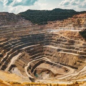
SimActive Enables 3D Calculations from Drone Imagery at Mining Sites
Mining requires a lot of measurements throughout the entire process. Measuring stockpiles, excavation progress, and terrain changes are a few of the points of data that need constant progress monitoring. Historically, this process was time consuming, but now with high resolution drones paired with appropriate software, this work can be done in a fraction of the time and is also much safer. Drone photogrammetry paired with Correlator3D gives high accuracy results. SimActive aims is a Quebec based company that is a “global provider of photogrammetry software for processing aerial imagery”. Read more here and here


Be the first to comment