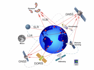
Environment
Pesticide use public presentation using ArcGIS StoryMaps and Instant Apps
The beginning of the story In the past summer, Kamloops Food Policy Council (KFPC) launched a research project to study…
Canadian BIM and Digital Twin Digest for December 15, 2022
COP27 Reveals More Needs To Be Done To Fight Emissions Canada’s Parliamentary Complex Gets a Face Lift Thanks to Digital…
The Federal Government of Canada Geospatial Director’s Panel at GeoIgnite 2022
During the WinterGeo summit this past March, a collection of some of the most prominent names in Canadian Geospatial sciences…
Cansel Discusses Innovations in LiDAR: Latest Technologies Across Industries
On April 5, 2022, LiDAR COMEX 2022 held a live stream presentation by Cansel. The topic of “Scan to BIM…
GoodScore.City: Comparing the Environmental Health of Canada’s Downtown Cores
The Canadian Urban Environmental Health Research Consortium (CANUE) is a group dedicated to understanding urban living and its impacts on…
Canadian Geospatial Briefing May 10th: Developing Tools to Protect Canada’s Biodiversity; Tracking impact of industrial projects on B.C. species at risk; 3D satellite mapping shows that glaciers are melting faster than ever; Geospatial Maturity Index shows that Calgary is a leader in GIS programs; Community engagement to measure impact of climate change on coastal environments in the Estuary and Gulf of St Lawrence; Surprising locations in Canada that have seen the largest increase in house prices
Carleton and Partners Developing Tools to Protect Canada’s Biodiversity Dr. Joseph Bennett, a biology professor at Carleton University and his…
Canadian Geospatial Briefing April 12th: GeoIgnite 2021 Keynotes, Talks, & Panels; Mapping project illuminating links between environment & racism; Remote sensing of agriculture to spot disease risk; Interactive map of Dinosaur Fossils in Canada; A literal map of Canada
Canadian Geomatics & Space Policy & Gov Updates: GeoIgnite Keynotes, Talks, & Panels This year’s GeoIgnite conference will feature many…
Canada supports innovative solutions for agricultural and environmental challenges
Climate change is destabilizing our environment and bringing more extreme weather. Farmers and agricultural workers know, first hand, how important…
Hatfield releases R-BAM algorithm to all Canadian wildfire agencies
The Rapid Burned Area Mapping (R-BAM) technology was developed over the last three years by Hatfield Consultants and aims to…
Your Global Location Technology Briefing for May 8th: Copernicus, Smart Cities, Cambridge Analytica, EarthTime, Landsat & half a quarter of a billion dollars of geospatial contracts
These stories are making waves in world geospatial news. The dark side of smart cities, a possible pay-wall for Landsat…
M.A. or M.Sc. Opportunity – Environmental Assessment and Resource Mgt
M.A. or M.Sc. Graduate Research Opportunity Department of Geography and Planning University of Saskatchewan Opportunity: The Department of Geography…
May 16: Thunder Bay GoGeomatics Speaker: Rob Rempel – Research Scientist MNRF
You are cordially invited to our fun free event geomatics networking event on May 16th. Tuesday, May 16, 2017 –…