
In previous article published on Gogeomatics, Overcoming Conflation, we explored what conflation is, why it happens, and how global initiatives like the Overture Maps Foundation aim to address it. But the question remains: Can Overture sufficiently address conflation challenges in the Canadian geospatial landscape?
Why Canada is Unique
Canada’s mapping needs are unlike many other countries due to several distinct factors:
- Bilingual Requirements: Place names, addresses, and map labels must be provided in both English and French.
- Indigenous Land Considerations: Mapping must respect, represent, and involve Indigenous communities and territorial rights.
- Jurisdictional Fragmentation: Provinces, territories, municipalities, and federal agencies each maintain their own datasets, often with varying formats and standards.
- Established Datasets: Canada already has authoritative national base maps like GeoBase which is updated and maintained by federal institutions.
These complexities mean that a global solution like Overture is not the only fix. Instead, it could serve as a foundation to ensure relevance and sovereignty.
What Canada Has Now
Canada currently lacks a fully integrated, continuously updated, open-data mapping initiative like Overture. However, several notable platforms and programs already support national mapping efforts:
1.GeoBase
- GeoBase is a federal-provincial-territorial initiative designed to provide open access to quality geospatial data.
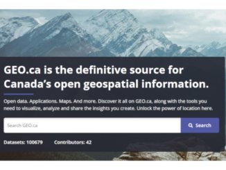
2. FGP and geo.ca
- FGP is an internal federal government website for federal contributors to publish geospatial data to open-source data repositories led by the Government of Canada (e.g. geo.ca).
- geo.ca is Canada’s national platform for discovering, visualizing, analyzing, and sharing authoritative open geospatial and Earth Observation data.
- OSM includes robust Canadian contributions, with active edits by local communities and some municipalities.
- However, Canada lacks a government-led OSM-based initiative, unlike some European counterparts.
4. Provincial & Municipal Basemaps
- Many provinces and cities maintain their own authoritative basemaps:
These are open and well-maintained, but not collaborative or interoperable across jurisdictions. This leads to redundancy, misalignment, and gaps when integrating datasets.
Why It Matters
A unified, collaboratively maintained base map could address several systemic challenges in Canada’s geospatial landscape:
- Data Sovereignty: A Canadian-controlled layer built on Overture’s base ensures compliance with national priorities.
- Interoperability: Standardized schemas across jurisdictions will ease conflation and support smarter decision-making.
- Cost Efficiency: A shared, open foundation reduces duplication of effort across governments and agencies.
- Future Readiness: Supports initiatives like smart cities, digital twins, climate modeling, and Indigenous-led mapping.
So, Could Overture Solve Conflation in Canada?
In short, Overture Maps Foundation alone is not enough, but it’s a strong foundation.
Canada has the data, the talent, and the policy environment to build a sovereign mapping layer atop Overture’s global infrastructure. Doing so would allow the country to:
- Align with bilingual and Indigenous mapping needs
- Preserve existing investments in GeoBase, FGP, and OSM
- Lead by example in open geospatial governance
If you’re aware of additional national or provincial initiatives that tackle these challenges, or local examples that are advancing interoperability, feel free to share them with us. We’d love to include them in future updates.


Be the first to comment