
The Department of National Defence (DND) is seeking public feedback on the Arctic Over-the-Horizon Radar (A-OTHR) program in southern, Ontario, part of a key NORAD modernization initiative.
As part of an announcement published last week, the DND stated that it aims to ensure our defence capabilities are relevant and inclusive for all Canadians, with input from Indigenous, intergovernmental, and community partners. DND is committed to maintaining strong relationships with local communities as we implement these NORAD modernization efforts. The department proceeded with acquiring a site in Kawartha Lakes, Ontario, and a site in Clearview Township, Ontario, for the program.
How to participate
Share your ideas online
Use the online form to share your comments and questions.
Participate in person or virtually
DND will host information sessions and town halls where you may learn about the program from DND representatives and technical experts, ask questions and share feedback. Dates and locations will be announced soon.To receive updates on upcoming information session and town halls, please sign up here.
Who is the focus of this engagement?
DND will engage with:
- The public
- Indigenous rightsholders
- Municipal and provincial stakeholders
Key questions for discussion:
- Do you have questions about the A-OTHR transmit site located at Thistle Trail in Kawartha Lakes? If so, what are they?
- Do you have any questions about the preliminary receive site located in Clearview Township? If so, what are they?
- Do you have information on environmental or archaeological considerations regarding either of the sites?
- Are there seasonal activities in the area that DND should be aware of when planning for construction?
- Are you a neighbour with specific questions or comments that you would like to communicate?
About the Arctic Over-the-Horizon Radar (A-OTHR) program
In June 2022, the Minister of National Defence announced Canada’s plan to modernize our contribution to NORAD with a total funding of $38.6 billion over 20 years. NORAD modernization is an important step in addressing Canada’s renewed requirements to strengthen the all-domain defence of Canada and North America.
As part of Canada’s NORAD modernization plan, DND is investing in a new Northern Approaches Surveillance System (NASS) to significantly expand NORAD and the Canadian Armed Forces’ (CAF) situational awareness of objects approaching and entering Canadian airspace from the North. NASS will include the A-OTHR system that will provide early warning radar coverage and threat tracking.
Locations in Southern Ontario
The A-OTHR capability will be in Southern Ontario and will extend NORAD and the CAF’s situational awareness into the Canadian North and the North Atlantic.
Over-the-Horizon Radar can conduct surveillance at far greater ranges than regular radar technology as it bounces radar beams off the ionosphere to see around the curvature of the Earth (see feature image on top).
The A-OTHR system needs to be in Southern Ontario to meet NORAD surveillance requirements.
Up to four permanent sites will be required for the system’s final two transmit and two receive locations. DND is currently assessing possible siting locations in southern Ontario.
The sites will be parcels of land ranging in size from a minimum of 100 hectares to 1200 hectares and will be located south of the 46th parallel north (as a frame of reference, this latitude roughly aligns with the Trans-Canada Highway) within the provincial border of Ontario.
Two Sites identified for Stage 1
DND purchased two sites in southern Ontario:
- Kawartha Lakes site: to be used as a full, permanent transmit site
- Clearview Township site: to be used as a preliminary receive site
A-OTHR will be implemented in a staged approach, with Stage 1 setting the foundation for further development and expansion of the system.
In July 2023, before purchasing the two sites, Public Services and Procurement Canada (PSPC) posted notices on Canada Buys and in community newspapers to advise property owners that DND was interested in buying land in Southern Ontario. They were given a deadline of August 31, 2023 to confirm their interest. DND also contacted private landowners, Indigenous communities, other federal government departments, and the Province of Ontario to assess siting opportunities. The options proposed during these discussions were found to be unsuitable for the program. DND proceeded with the purchase of the Kawartha Lakes and Clearview Township sites, privately owned land parcels listed on the open market.
Kawartha Lakes: Transmit Site at 0 Thistle Trail
A map of the A-OTHR transmit site at Thistle Trail can be found below (figure 2).
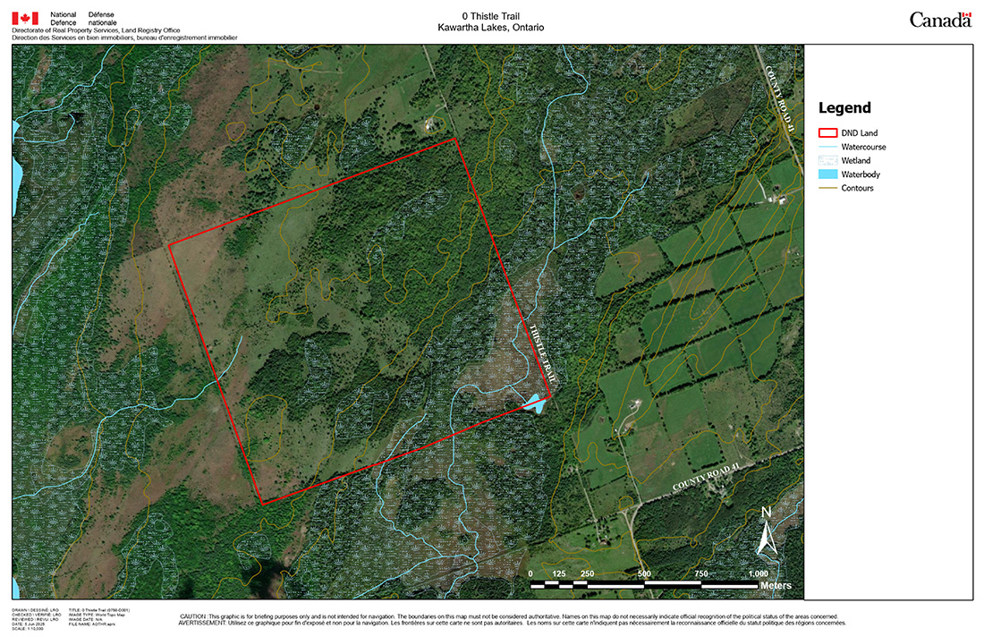
Site details:
- 163-hectare of vacant property comprised of a mix of pastureland, forest, and marsh lands.
- At the time of acquisition, the lands were actively used for cattle grazing.
- The property contains some wetlands and wooded areas located throughout the site.
- Observed wildlife includes various mammal, bird, reptile, and amphibian species, including federally and provincially listed Species at Risk.
- Surrounding lands consist of rural residential and agricultural uses.
- Development on nearby lands must be compatible with radar operations. This may restrict how surrounding land is used in the future.
Clearview Township: Preliminary Receive Site at 2225 Sideroad 15 and 16
A map of the preliminary A-OTHR receive site in Clearview Township can be found below (figure 3).
Site details:
- 288-hectares of agricultural land with some farm structures on the west side of the site.
- At the time of acquisition, the lands were actively used for growing and harvesting crops.
- The property consists of some wooded areas on the east side and is bisected by a creek.
- The site overlaps with provincial Areas of Natural and Scientific Interest (ANSI).
- The site falls within the regulated area of the Nottawasaga Valley Conservation Authority.
- Surrounding land consist predominately of agricultural lands with limited recreational and commercial uses.
Ongoing Siting Analysis
DND’s siting analysis for A-OTHR is driven by a set of complex and inflexible requirements. These include parcel size, latitude, orientation, distance separation between parcels, environmental conditions and constraints, and adjacent land use.
Potential sites must be:
- located in a remote, flat, and dry area
- have limited environmental constraints
- a suitable distance from radio noise sources
- close to electrical power sources
For these reasons, suitable permanent sites for A-OTHR are relatively limited and our analysis continues. We look forward to sharing additional siting information when it becomes available.
What the A-OTHR will look like
The A-OTHR sites located in Southern Ontario will consist of four antenna sites (two transmit and two receive sites) and supporting infrastructure. The program is expected to be accommodated on lands acquired for this program and existing DND sites.
Land preparation will be required for each location, including flattening of the land and removal of any obstructions that would impede the radar’s signal, including potential clearing of forested areas or filling of wetlands.
The transmit sites will have a radiofrequency radiation hazard zone entirely contained within the site and be fenced to prevent access.
Program timeline
Initial work is anticipated to begin at the Kawartha Lakes and Clearview Township sites as early as winter 2026, with the initial stage 1 capability to be installed by the end of 2029.
Regarding future stages of the program, DND is committed to sharing detailed information as it becomes available. The full A-OTHR capability is anticipated by 2043.
Environmental impacts
DND will conduct several environmental and site studies at both sites, including:
- an environmental site assessment to determine whether the sites contain any existing soil and groundwater contamination,
- an assessment of the watercourse and wetlands within or in proximity to the program area that may be impacted by the program,
- a flora and fauna assessment to determine a baseline that includes migratory birds, at risk wildlife (legislated both federally and provincially), and identification of habitat types in the program area and surroundings, and
- an archaeological assessment of the area.
Once these studies are done, an environmental effects determination will be completed under the Impact Assessment Act (IAA) to support the program’s ongoing design and specifications. This determination identifies potential adverse environmental impacts and identifies mitigation measures to be implemented to minimize the potential adverse effects.
Health and safety
The areas surrounding the sites will comply with the national safety standards for human exposure to radiofrequency electromagnetic fields established by Health Canada. Fencing will be installed around the sites to ensure the public is not exposed to potential hazards. There are no known adverse human health effects associated with the receive sites.
Ground level
At ground level for the transmit sites, hazardous radiation zones will be contained within the perimeter of the fences and away from human exposure. There are no known adverse human health effects associated with this type of technology at distances beyond the perimeter fence.
Aircraft altitudes
Up higher (at aircraft altitudes), the program will work with transportation authorities to put in place guidance and restrictions for affected airspace to keep human exposure to electromagnetic fields within the safe levels per the Health Canada standards.


Be the first to comment