
Every minute, satellites orbiting Earth collect an extraordinary stream of information, more than 100 petabytes of Earth science data to date.
These orbiting observers track everything from raging wildfires and shifting climate patterns to agricultural health and urban expansion. Behind the numbers lies a powerful story: data that can shape smarter disaster response, guide sustainable farming, predict disease outbreaks, and drive evidence-based policy.
The challenge now isn’t collecting information it’s unlocking its full potential for a better, more resilient planet.
The Growing Challenge of Geospatial Data
Geospatial data is vast — and growing more complex by the day. As its volume expands, so does the expertise required to make sense of it. Turning raw spatial data into actionable insight demands advanced technical skills, innovative tools, and the ability to perform sophisticated analyses that can drive real-world impact.
This complexity poses a major challenge. Scientists analyzing historical flood data to test predictive models, or policymakers trying to interpret deforestation maps, often struggle with incompatible formats and steep technical barriers. After all, “geospatial” encompasses everything on Earth — and managing that scale of information is no small feat.
As global datasets multiply exponentially, making them accessible and usable to a broader range of people has become essential. Democratizing data through advanced technology could unlock new insights and faster, more effective solutions. Recognizing this need, NASA has turned to innovation unveiling Earth Copilot, powered by Microsoft Azure AI, to help bridge the gap between data and discovery.
How Microsoft Azure AI Powers NASA’s Earth Copilot
NASA’s IMPACT team has partnered with Microsoft to develop an AI-powered assistant called Earth Copilot — a prototype model that combines Microsoft’s Azure cloud platform with advanced artificial intelligence. The tool is designed to transform how users search, discover, and analyze NASA’s vast repository of geospatial data.
With Earth Copilot, users can interact with complex Earth science datasets through simple, natural-language queries. For instance, someone might ask, “What was the impact of Hurricane Helene?” — and the AI would instantly retrieve the most relevant datasets, streamlining access to critical scientific information.

NASA’s Earth Copilot taps into the power of Microsoft’s Azure OpenAI Service, using advanced cloud and AI technologies to make complex Earth data easier to explore. By combining natural language processing with NASA’s own VEDA (Visualization, Exploration, and Data Analysis) platform, the agency is transforming how scientists — and soon, the public — can search, discover, and analyze Earth science data. What once required coding expertise can now begin with a simple question, making access to planetary insights more intuitive than ever before.
“Azure’s robust suite of services, including machine learning, data analytics and scalable cloud infrastructure, powers this AI prototype,” said Juan Carlos López, former NASA engineer and current Azure Specialist at Microsoft. “
How This Innovation Elevates Geospatial Applications
The Earth Copilot feature within Microsoft Azure facilitates interaction with geospatial data through natural language queries, eliminating the need for programming.
This model is an example of Queries grounded in private storage data through Retrieval Augmented Generation (RAG)
It enables the generation and execution of SpatioTemporal Asset Catalog (STAC) API queries and provides access to over 126 Microsoft Planetary Computer (MPC) STAC collections.

Building upon the NASA and Microsoft Earth Copilot 1.0 prototype, version 2.0 introduces a production-ready architecture developed using contemporary AI agent frameworks.
This advancement results in an intelligent system capable of comprehending scientific inquiries, autonomously identifying appropriate datasets, and providing interactive visualizations—all facilitated through natural language interaction.
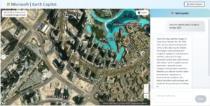
This is an example of Contextual queries looking for information
- Users can search across private, public, or hybrid datasets and visualize various STAC collections using Azure Maps.
- Furthermore, Earth Copilot can be seamlessly integrated into individual research workflows within the Azure environment.
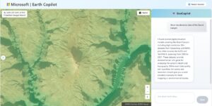
Above is an example of Queries that require map visualizations.
- Building upon the NASA and Microsoft Earth Copilot 1.0 prototype, version 2.0 introduces a production-ready architecture developed using contemporary AI agent frameworks.
- This advancement results in an intelligent system capable of comprehending scientific inquiries, autonomously identifying appropriate datasets, and providing interactive visualizations—all facilitated through natural language interaction.
Looking Ahead
Earth Copilot represents more than a technological leap — it’s a step toward a more connected, data-literate planet. As Earth’s systems grow more complex, the ability to turn raw geospatial data into meaningful insight will define how we respond to climate change, manage disasters, build resilient cities, and sustain our food systems. Democratizing access through AI isn’t just about efficiency — it’s about empowerment.


Be the first to comment