In 1987, Frobisher Bay was renamed Iqaluit, the loonie was released by the Canadian mint, and there were 13 UTM zones that spanned across the Northwest Territories.
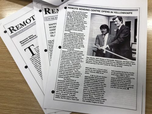
That was also the inaugural year for the NWT Centre for Remote Sensing.

The Centre was established through the Technology Enhancement Program; a pan-Canadian initiative led by the Canada Centre for Remote Sensing (CCRS) to transfer remote sensing technology and skills in collaboration with Provincial and Territorial governments to support resource management. What started off as a two-year pilot project, soon became a permanent fixture within the Government of the Northwest Territories.
Since then, more things have changed than the political boundary of the Northwest Territories. For instance, in the last thirty-five years, the once small Centre now includes teams specializing in Geomatics Services, Remote Sensing, and Enterprise Geospatial Systems with offices in both Inuvik and Yellowknife. This evolution is linked to a growing need for northern geomatics capacity and data availability in response to climate change pressures while increasing local control over land, water, and resources into the hands of Northerners. The NWT Centre for Remote Sensing was also rebranded over time to the NWT Centre for Geomatics (NWTCG) due to a broadened scope facilitating a wide range of geospatial tools for most facets of public administration.
Remote sensing remains a core focus of the NWTCG today as it continues to be a cost-effective tool for Canada’s north. Methods of analysis have become more sophisticated than they were in the eighties, and although some sensors have evolved towards increasing spatial and spectral resolution, conventional ones are still in use today that contribute towards long-term data archives. Combined with a more mature remote sensing sector, this has facilitated the development of monitoring programs that can track long-term landscape-level change in the Northwest Territories.
The NWTCG recently conducted an analysis of landscape change by using the open archive of Landsat Imagery and by employing Google Earth Engine to power through large volumes of data. The analysis included all Landsat scenes during peak growing season in the Northwest Territories from 1985 to 2019, covering the territory from border to border in what amounts to approximately 1.3 million square kilometres of data per year. Computationally speaking, this would not have been possible in 1987 when the former NWT Centre for Remote Sensing boasted about image analysis on a CCRS-loaned ARIES III system with a Micro VAX II computer and 340 MB hard disk. The results of this change detection analysis are now available as a REST service, and methods used to generate results are described in an Esri story map. These results coupled with field-level observations by subject matter experts are helping to spatially quantify various types of change such as wildfires, permafrost thaw, as well as urban and mineral development. These are also a few landscape pressures happening in Canada’s north affecting fish habitat, safe drinking water, and transportation routes.


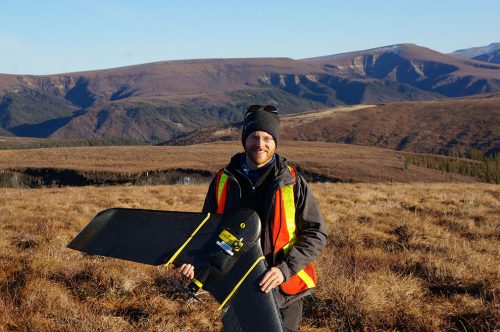
As with any large-area mapping initiative, field validation and interpretation are key components of a remote sensing project. To scale down from landscape-level remote sensing analysis, the NWTCG employs Remotely Piloted Aircraft System (RPAS) technologies and works closely with experts in other disciplines to validate and interpret results.
RPAS Coordinator, Jurjen van der Sluijs, has been supporting permafrost scientists from the Northwest Territories Geological Survey since 2015 on monitored sites throughout the NWT, including along Canada’s only all-season public road to cross the Arctic Circle, the Dempster Highway. Jurjen will be presenting some of his work at the virtual 2022 GeoIgnite conference and will demonstrate how field-based remote sensing and geo-enabled observations can provide a more detailed lens on permafrost thaw in the Northwest Territories. He will also present emerging northern opportunities that leverage Beyond Visual Line of Sight RPAS technology which can map areas orders of magnitude larger than conventional RPAS while keeping crews safely on the ground.

Evidently the field of remote sensing has changed considerably over the last thirty-five years and so has the NWT Centre for Geomatics. The future of digital geography, and in particular remote sensing, is compelling as computer processors continue to shrink, cloud computing expands, new types of smart sensors become available, and artificial intelligence opens doors to new forms of analysis and data automation. However, as impressive as these advances are, the NWT Centre for Geomatics recognizes that they are just a means to an end to promoting sustainable resource management and safe NWT communities. As such these tools and the data need to be carefully balanced with local knowledge and community expectations in the next 35 plus years by building relations and working towards co-production of knowledge, as well as equitable data access and ownership.


Be the first to comment