
GeoAI is to use artificial intelligence (AI) in conjunction with geospatial data to address geographically oriented problems. The combination of GeoAI and marine is not as widespread as in other sectors. Though promising for environmental monitoring both above and below the water, the volume of data and the cost of producing models have limited its ability to spread in the field of marine. Object detection, classification, and change detection are fundamental features of AI. They can be leveraged to enhance protection, and monitoring of marine environments.
GeoAI for marine monitoring
Beyond its traditional uses, GeoAI has the capability for more sophisticated applications.
For example, the United Kingdom Hydrographic Office (UKHO) attempted to establish a more precise baseline measurement of the global shoreline than was earlier done. By combining machine learning (ML) algorithms with human expertise, the extensive data gathered each day was transformed into detailed coastline maps.
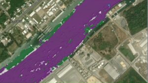
Results of time series forecasting. Violet indicates areas where sedimentation above the threshold is likely to occur.To achieve this, they used a pixel categorization technique called Otsu Thresholding, which splits the image into two categories: coastline and non-coastline. These maps enable the analysis of coastal erosion, and climate change impacts.
Esri and Hypack collaborated to produce a demonstration of model in which Esri forecasting algorithms would operate on Hypack data to predict where sedimentation will occur near the Port of Tuxpan, MX.
This method, referred to as time series forecasting, focuses on recognizing patterns and trends over time to generate accurate predictions about future occurrences. ESRI effectively showcased its ability to predict where, when, and how much sediment needs to be removed to ensure safe navigation in the channels.
In collaboration with Esri Canada, Canada’s Department of Fisheries and Oceans (DFO) explored the potential application of GeoAI, specifically deep learning techniques, to enhance the detection of Beluga whales within the collected imagery. Instead of the object identification method, they chose pixel-based classification, which involves segmenting pixels based on their values and spatial locations, thereby categorizing similar pixels into distinct classes. This approach reduces the labor-intensive tasks of ‘panning and scanning.’
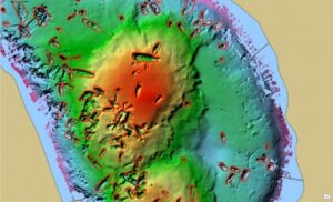
Using deep learning models and appropriate training data, identifying shipwrecks under the water and displaying them on a shaded relief map of the bathymetric surface is is another example of a fascinating experiment.
GeoAI in marine has implications and Limits
Use of GeoAI comes with its risks and challenges. Even though the models stand to show 90% confidence level, human intervention and validations are vital. Not just verifying what comes out but also what goes in.
- The training data needs to be verified before it is fed to the model to avoid misclassification and misinterpretation.
- Using the correct resolution for the object to be detected is the first step in preventing misclassification.
Consider the sedimentation research at Tuxpan, where it was straightforward to determine that the model predicted harmful levels of sedimentation in specific regions. However, variations are vital. What the model truly says is that, based on previous measurements, harmful amounts of sedimentation are statistically likely to happen in this location rather than elsewhere.
GeoAI approaches expect a considerable commitment of time. The time spent identifying objects for deep learning procedures or resampling datasets to match the model criteria is not straightforward.
Can GIS lower these risks?
Given that the objective of GeoAI is to address geographic issues, it is logical to select a GIS platform capable of managing the entire analysis process in the vast field of marine science.
- GIS can process data from various sources, including satellites, drones, ground scanners, and sonar devices. This flexibility allows analysts to concentrate on the most suitable application for the dataset after initially examining it to understand its format, resolution, and pixel type.
- There are numerous established built-in tools and Python libraries that the analyst can utilize to select the appropriate tool for the specific task, whether it’s labeling items for deep learning or executing an object detection process.
- Utilizing spatial extent parameters in GIS-based tools allows analysts to create smaller test areas for model evaluation before applying them to the full dataset. This approach can help reduce potential risks associated with computing resource limitations.
Data can be translated into important insights for research and analysis by incorporating GeoAI powers into marine applications using modern GIS systems. This will improve monitoring of the marine ecosystem and its distinctive features.


Be the first to comment