
This year, the GeoIgnite virtual conference brought the geospatial industry and community together into a grand event where they discussed the latest Geomatics trends in the country and the public geospatial services being offered by the federal government as well. On the 22nd of July 2020, the Canada Centre for Mapping and Earth Observation (CCMEO), under the management of its Director General Eric Loubier, delivered an opening keynote together with Jonathan Murphy, the Managing Director of GoGeomatics. The CCMEO is a branch of the Natural Resources Canada. This branch is the champion in geomatics and Earth observations works and platforms provided to several government divisions.
CCMEO Geospatial Program
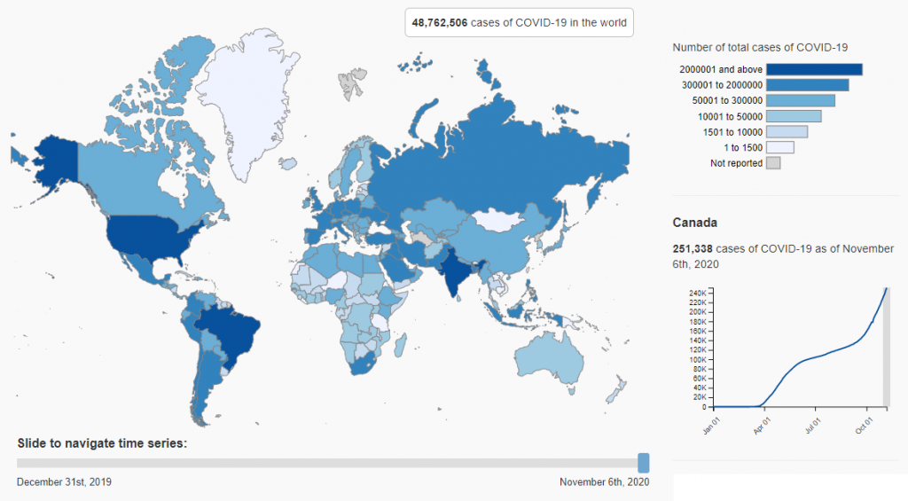
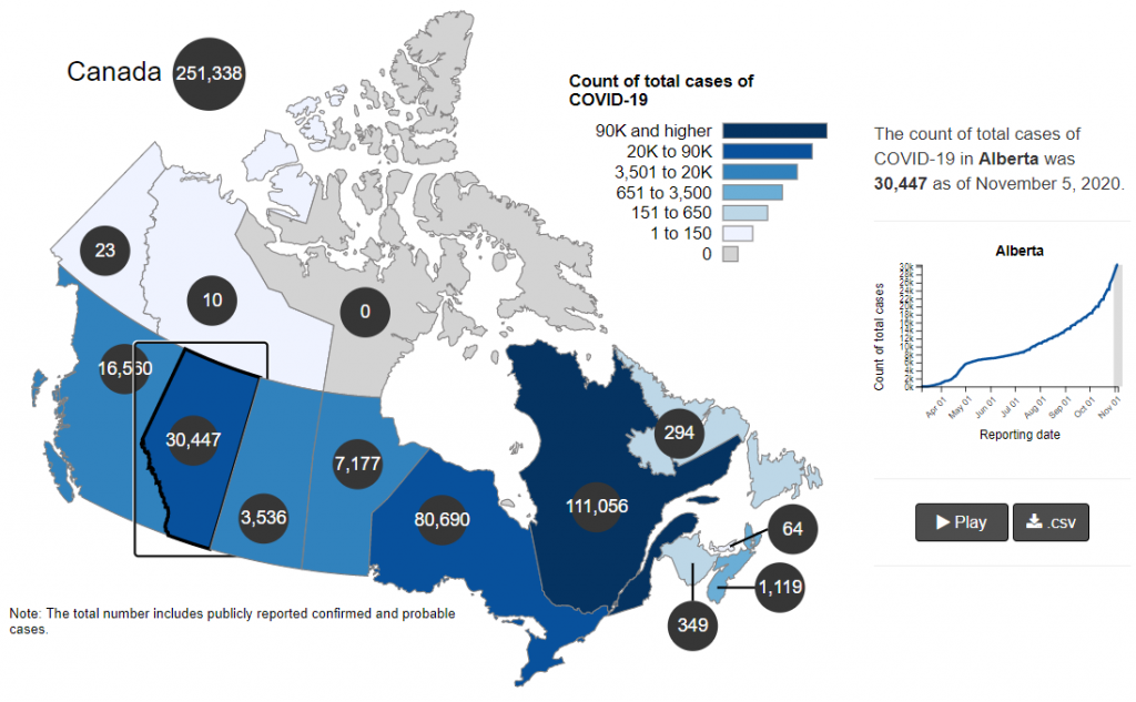
In this video, Eric delivers his presentation on the CCMEO’s geospatial initiatives. To begin with, the country experienced this year several unanticipated disruptions such as massive snowfalls, spring flooding and the COVID-19 pandemic. These disruptions, on the positive side, allowed this government branch to unlock new road maps and to develop new plans and strategies, which are quite handy for decision makers. At present, the CCMEO concentrates on reshaping public health and safety during this time of pandemic. Therefore, it pushed the plan on creating a GIS-based platform and dashboard with two intentions in mind. Firstly, to establish an interactive data visualization of COVID-19 that fully communicates the ground situation to all Canadians. Secondly, to geo-enable data in preparation for potential public policy crisis in the future and to influence decision outcomes as well.
Program Roadmap and Partners
This program is being performed in coordination with the Public Health Agency of Canada (PHAC) and other relevant government branches. The CCMEO also leverages the expertise of the private industry through the ESRI Canada and Amazon Web Services thus a team was developed to focus on this matter. To make this effort effective, CCMEO guarantees that it can gather essential geospatial data including those that are not marginally accessible and readily available and transfers its expertise to decision makers to mobilize geospatial capability.
Geospatial Platform Features
The CCMEO desires to deliver cleaned, standardized and organized geospatial data in substantial quantity through an enterprise cloud infrastructure. To make this possible, the CCMEO is investigating contemporary technology, machine learning and artificial intelligence to produce an automated data processing mechanism. On the other hand, the geospatial platform can be found through this webpage: https://health-infobase.canada.ca/covid-19/visual-data-gallery/.
Keynote Video
If you missed the conference, below is the full coverage of the YouTube video that contains the keynote and the link as well if you are having a technical problem accessing it.


Be the first to comment